


WHERE FOR ART THOU WINTER
- Dec 23, 2025
- 4 min read
It's officially winter now, and wouldn't you know it, winter is nowhere to be seen, at least in its true form locally. The same can't be said for the last three weeks of fall, when cold and snow bombarded the region after Thanksgiving. Here in Dubuque, we had 18.3 inches of snow in the 10-day period November 28th through December 7th. Here's the snow totals from the Iowa Mesonet for the period November 28th through December 15th. Some spots in Cedar and Clinton County had up to 25 inches. That is off the charts impressive.

Temperatures during that same 18 day stretch averaged as much as 12 degrees below normal per day! Cold dominated the entire state of Iowa and much of the Midwest. What a stretch of winter weather.

Well, as the saying goes, easy come, easy go. Now that winter is here, the weather pattern has undergone a radical change and, the snow has been reduced to piles in my southern counties and no more than an inch or two in isolated spots in the N/NW. This high resolution satellite imagery taken with fair skies shows the southern extent of the snow cover nicely. You can also see the river valleys of eastern Iowa carved into the snow pack, which is pretty nifty. A much more substantial snow cover exists in the NE half of Minnesota and much of Wisconsin, which is going to be a factor in how far north some exceptionally warm air can get this Christmas.

As you may recall, as recently as last Friday the GFS was pretty gung-ho with highs reaching near 70 in the far south Christmas day. Take a look.

However, the EURO was catching on to the idea of the snow pack acting as a glacier and blocking the northward extent of the warming with temperatures that were considerably colder. I made a mention in my last post Friday that my northern counties would likely be significantly cooler than the south. Today, models are even stronger with a high pressure over the northern Great Lakes and keep winds out of the E/SE Christmas.

That is the kiss of death for 50s and 60s locally as it holds the warm front with record warmth further southeast. We're still mild and above normal, but nothing like we could have been without so much snow just to the north and air bleeding off it. The EURO now has highs in the upper 30s to upper 40s.

The GFS is a hair warmer, but now fully on board with the cooler look. You have to get south of St. Louis to hit 60 with the 70s forced from SE Iowa to SW Missouri and southern Illinois.

What's fascinating is that the 500mb charts Christmas day show heights of 576 up to the southern Iowa border. At first glance, you would think that would easily support highs in the 60s with a full on blow torch.

Even at 850mb (a mile up), readings are +12 to +15 degrees C.

So what this tells us is that from 1 to 3 miles up, temperatures are far above normal. But, due to the surface winds and nearby snow pack, cold dense air is undercutting the warmth aloft. This is what is known as a temperature inversion, (readings are warmer higher up than they are lower, which is not typically the case). This happens a lot in the spring. We can't complain much, as we end up 10–14 degrees above normal, but not the 30 degree stuff found further south. In fact, you can see just northeast of the lakes, temperatures are 10–12 degrees below normal and that's the wall that is holding the warmth at bay.

GIVE THE GIFT OF MY 5 STAR AIRBNB IN GALENA

Holiday and winter specials are now in effect through March. Let us help you set up a personalized gift certificate that's sure to create a lifetime of memories! Santa Claus approved. Call or text Carolyn at 563-676-3320 for details and our very best pricing. https://www.littlewhitechurchgalena.com/
A MILD HOLIDAY WEEK
As you can see, the GFS meteogram does try and punch a 56 degree high into the Quad Cities Saturday, but I have serious reservations about that. Readings do get a colder as we approach the New Year, however, northing that is at all bad for that time of year. I can remember many a New Year's Eve with temperatures near or below zero with a frigid wind.
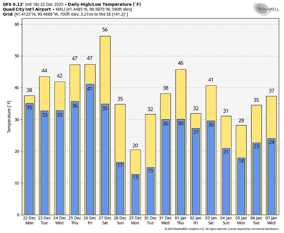
By the way, leading up to Christmas highs Tuesday through Friday should range from near 40 north to the upper 40s south, perhaps as warm as 50 in the far south a couple of days. The Climate Prediction Center shows a strong signal for above normal temperatures to close out 2025.

As for precipitation, I don't see much, but a few light showers or some drizzle is possible late Wednesday or Wednesday night, especially in the southeast. The more organized rains should be further E/SE. Another disturbance, Christmas night has a better chance of squeezing out some showers, for the most part after the evening hours. One thing that does concern me some, is the potential for fog and low clouds to develop. Inversions are known for trapping low level moisture, particularly this time of year, and I'm not looking for much in the way of sunshine (if any) Wednesday through Thursday. Hopefully and fog won't be dense, but there is some risk of that both Christmas Eve night and Christmas. Here's suggested rain totals Wednesday through Thursday night. Most of this comes Christmas night. Sadly for me, no snow!

In fact, snow does not look to be a player the next two weeks. The EURO shows this for snow through January 6th. Here in Dubuque, that would mean 30 days with not so much as an inch of snow. The previous 10 days we knocked off 18.3 inches. Go figure.

That's where I will leave it for now, if you are traveling the central Midwest, no ice or snow the remainder of the week and Saturday. Temperatures should turn colder for a day or two Sunday. Roll weather...TS


Comments