


BUCKLE UP, WILD TIMES AHEAD
- Mar 12
- 5 min read
Tuesday in Galesburg, Illinois (while I chased tornadoes), I had the pleasure of enjoying an 80 degree temperature for the first time in 5 months. Wednesday, back at my home in Dubuque it snowed much of the day, with a reading at noon of 34 degrees. A stiff NW wind had the wind chill at 22 degrees. That was a serious wake-up call. So much for the summer preview! I'm sorry to say there's a lot more where that came from and the next 6-7 days we will be riding the crazy train. Time to buckle up buckaroo.
WINDY TIMES...
The initial challenge facing forecasters is associated with a an intense 500mb trough/clipper that sails across Minnesota and Wisconsin. Ahead of the energy, warm advection associated with a warm front spreads into the region during the day. A light SW early morning breeze rapidly increases due pressure falls in advance of the system. Gusts of 35-40 mph drives morning temperatures from the 20s, into the range of 45-50 by mid-afternoon. Clouds will be on the increase as well as the day progresses, with a narrow plume of moisture ahead of a cold front.
Monday evening the clipper is entering NW Minnesota with mild SW winds ahead of it.

Thursday evening, a rapidly moving cold front will generate scattered showers as it makes its way SE. Most of the rain of any consequence looks to be near or north of I-80. Even there, amounts should be 1/10th of an inch or less. Friday at daybreak, the surface low has reached Green Bay. With the cold front having cleared the region, any showers are long gone as cold air advection scours out moisture and turns winds northwest.

On the topic of winds, conditions Thursday night are ripe for very potent gusts due to an enhanced pressure gradient. This, combined with strong cold air advection synoptically creates the potential of gusts reaching 35 to 45 mph areawide, with some gusts approaching 60 mph over my NW counties. The HRRR shows this for 10-meter wind gusts Thursday night.
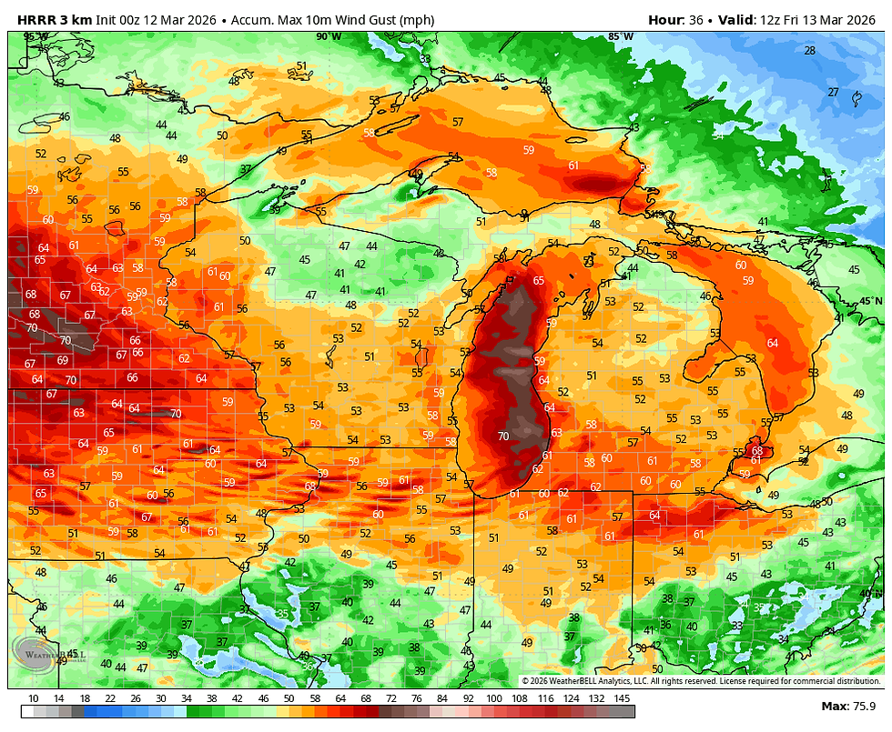
A high wind watch has been issued NW of a line from Cedar Rapids to Dubuque Thursday night into early Friday. Other locations further south could also see wind headlines expanded by Friday morning as the event becomes clearer. It's going to rock the house.

Friday dry conditions prevail under stout cold air advection and subsidence. Winds will gradually decrease, especially in the afternoon as the pressure gradient relaxes. Highs dip back into the range of 40-45.
IF THAT DOESN'T IMPRESS YOU, THIS SHOULD
If that didn't do it for you, this should. Models are in good agreement that a deep springlike storm will take shape later Saturday into Sunday. You can watch the energy dig into the Midwest and explode into a formidable storm as it grinds across the Great Lakes.

As mentioned, confidence is high a storm is coming. What's still to be determined is the exact track and intensity. Whatever happens with Thursday nights clipper will be a critical factor as it leaves more than enough cold air to create a multi-faceted system with snow in the cold secto NW of the low, and some severe weather to the SE in the warm sector. The depth of the cold air and how far south it reaches will determine the eventual track.
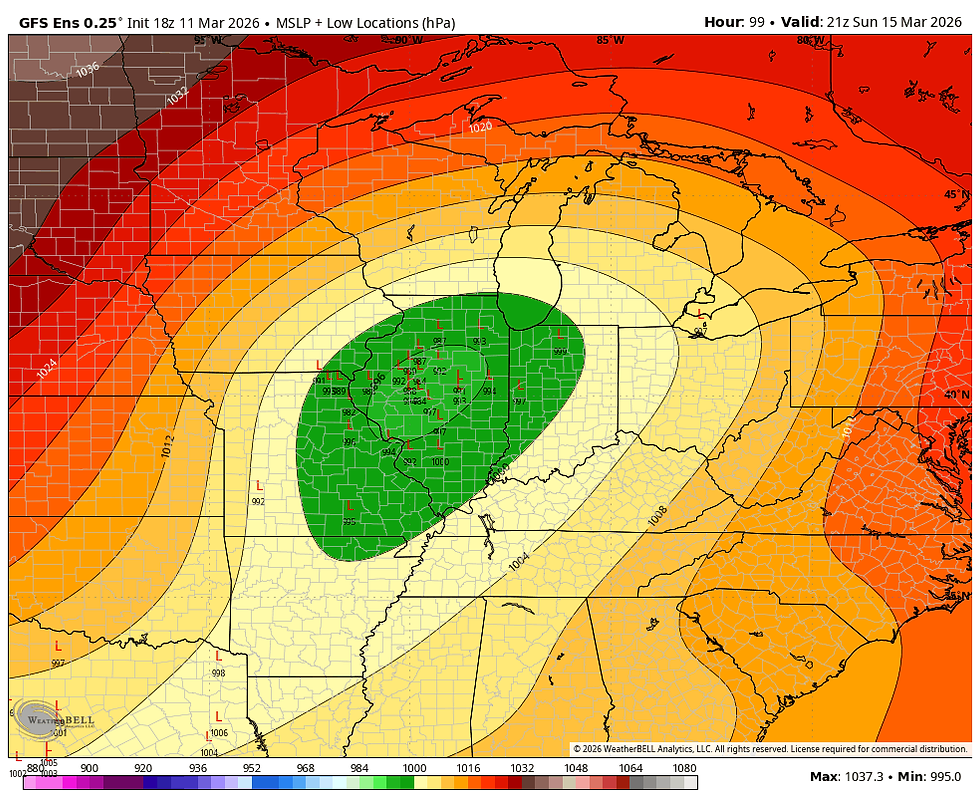
Using the ensembles, we see small differences on the mean tracks of the EURO and GFS that make big differences in overall impacts. The EURO EPS depicts a mean track we have seen a zillion times before that goes right over SE Iowa. You can see the individual member plotted below.

That gets much of my area in the warm sector for the first 2/3rds of the storm. That also puts a significant heavy snow threat over far northern Iowa into Minnesota and Wisconsin. Rain would eventually change to snow on the backside of the low with several inches of accumulation possible, especially in my northernmost counties. It also sends a dry slot through the heart of the region which reduces precipitation potential locally. This is what the EURO ensemble mean comprised of 51 members looks like.

The GFS has the cold air entrenched further southeast from the clipper and its ensembles indicate a track through central Illinois. That keeps most of my region in the cold sector with more significant precipitation and winter storm potential. A colder overall solution.
Should the GFS verify, that could spell big trouble with a heavy snow threat that looks like this on its ensemble means.

So, just 3 days before the event, we already have all kinds of problems with temperatures and precipitation type. The warmer EURO could even bring thunderstorms (some strong SE of the low), while the GFS has a very minimal chance of any storms.
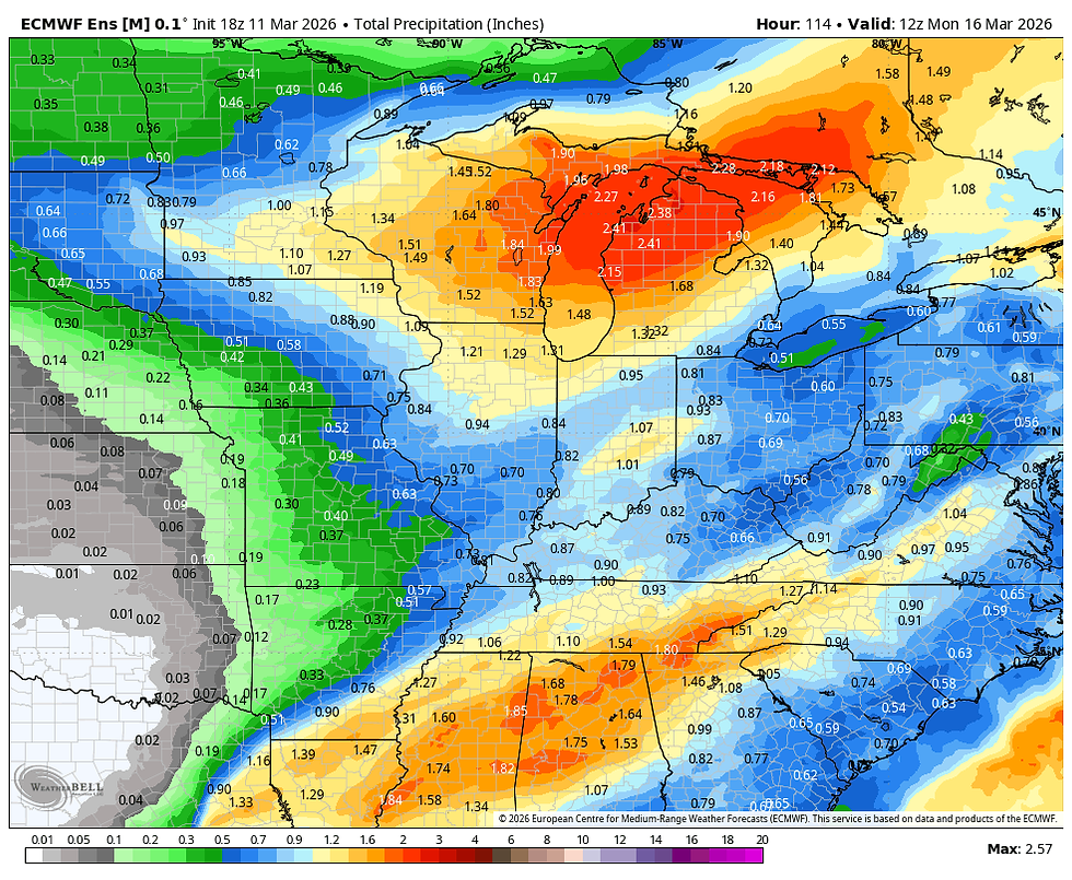
Total precipitation on the EURO ensembles is lower due to the impacts of the dry slot. There also appears to be a slower moisture injection on the EURO. You can see the difference below on amounts, particularly out west.
The EURO ensemble mean Saturday through Monday morning.
The GFS ensemble mean for the same period.

In summation, a 100 to 150 difference in track has major implications as to the type of weather we see this weekend. Knowing the way these usually work out, the EURO track over SE Iowa probably ends up winning the day. That said, until I see what happens with the cold air depth Friday, I reserve the right to stay on the fence for a day longer.
Two things that appear certain is the fact the storm is likely to be a another wind machine. Wind gusts Sunday night could again exceed 50 mph. If that coincides with snow that's quite problematic. This has the potential to be a very substantial, even crippling winter storm for some part of the Midwest. Best chances of that happening currently are just NW, from northern Iowa into Minnesota and Wisconsin.
The other certainty aside from more wind, is a very healthy shot of cold air that dives in behind the storm Sunday night into Tuesday of next week. These are highs Monday on the EURO. The GFS with much more snow is even worse. I will disregard showing that.

Monday afternoon the EURO depicts temperatures that are 30 degrees below normal.

Wind chills Monday are below zero in most areas.

Rest assured the next few days are going to be chalked full of weather. Most of it far from pleasant. The primary goal is to get a handle on the strenght and track of the weekend storm which looks potent. Until next time, roll weather...TS
PS. I'm happy to say that I reached my financial fundraising goal. My sincere thank you to all of you who made contributions and have taken it upon yourself to support the site. TSwails is with you for another year. If you haven't contributed, and think the site has value, or you use it extensively, it is still possible to donate. Any contributions will go into a trust to be used to support the site going forward. Thanks again!


Comments