


MAJOR MIDWEST WINTER STORM...
- Mar 13
- 5 min read
A WINTER STORM WATCH FOR SUNDAY NIGHT NORTH OF I-80
Details on this last minute development later in the post!
A significant late winter storm is expected to blast the upper Midwest Saturday night through Monday morning. The storm has the potential to be of historic proportions (that's according to the NWS) over parts of southern Minnesota and Wisconsin, where 18-24 inches of snow could fall in spots. Combined with 50 mph winds, blizzard conditions are expected in that general area with significant travel disruptions. Winter Storm Watches extend as far south as HWY 20 in Iowa and the northern Illinois border in Wisconsin.

The National Weather Service snowfall forecast shows this for potential snow accumulations through the day Sunday. Sunday night snow will wrap into my area but amounts from that are not depicted on the graphic below.

While my area is shown missing the worst of the initial snow and extreme effects of the system, rain is expected to change to snow Sunday evening with the potential of several inches of accumulation in some parts of my area. A rapid temperature fall combined with winds of up to 50mph is likely to cause travel issues in those areas and advisories of some sort are eventually quite possible. But, as it stands now, the brunt of the initial storm through the day Sunday stays to the north, where major to extreme impacts bypass the local area.

As I write this, I should point out that my forecast is heavily influenced by the EURO through the day Sunday (which to me is the most climatologically sound solution through that time frame). If you've lived here for any length of time, you know the sweet spot for these intense storms is for them to track right up through the slot of eastern Iowa. That indeed is what the EURO depicts initially, and I find it hard to argue with that solution. Here it shows the deepening surface low tracking towards Dubuque mid-morning Sunday.
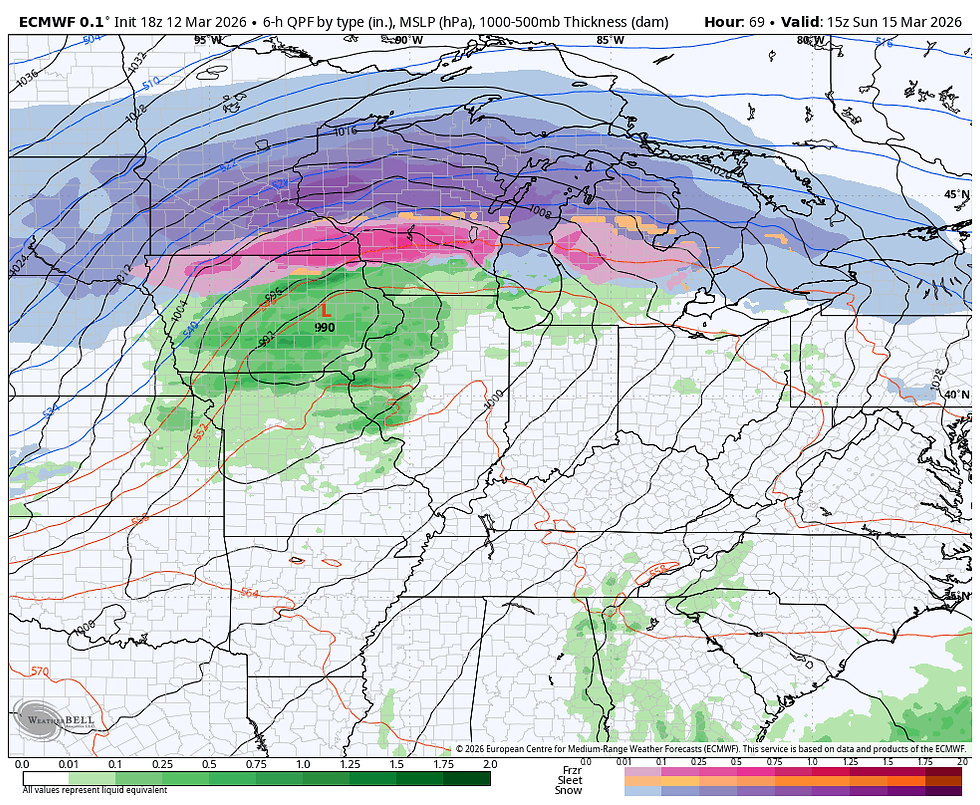
One issue that is troubling and problematic, is that the operational GFS is digging the system further south, injecting energy Sunday evening that reforms and pulls the surface low east towards Chicago. That ignites a heavy burst of deformation precipitation over eastern Iowa and NW Illinois. Its colder solution turns it to heavy snow by evening where it continues much of the night. It also coincides with the maximum winds of 45-50. Here's its surface depiction at 10:00pm. Sunday.

Look what it shows for snow, all of this after 6:00pm Sunday! What a mess that would be west of the Mississippi.

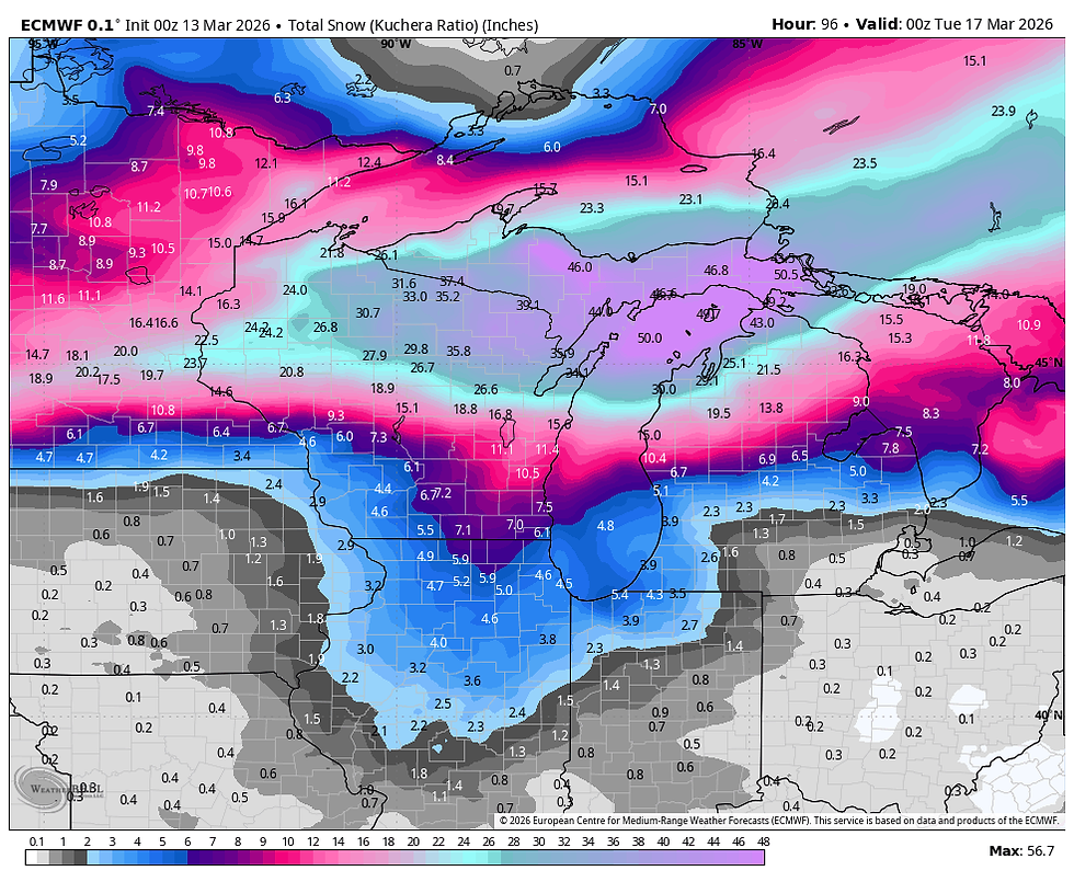
Here's what the snow amounts look like on the EURO through Monday.
Unless the GFS is seeing more digging in the tough, a trend the EURO is not, I'm unsure about its solution. It's pretty clear that we miss the initial snow Saturday night/Sunday, but get a second chance with a wave of snow locally Sunday night. The 3k NAM also indicates the trend making it a wild card that could change the game locally at that time. I am certain we are snowfree through the day Sunday, but after that, all bets are off as to what happens Sunday night.
THIS JUST IN AT 3:00 AM. FRIDAY
The NWS has just now put out a Winter Storm Watch for Sunday evening through Monday for much of the area along and north of I-80. The gist of the watch is that snow totals of 5-9 inches are possible along with 50 mph winds and blizzard conditions. This obviously takes into consideration the higher snow totals that the GFS depicts.

With either the GFS or EURO solution, little if any snow is likely before Sunday night in my area. There is a chance a band of light snow could streak though the north Friday night as warm air advection kicks in, mainly north of I-80. Little if any accumulation is expected if it can develop, moving out early Saturday morning. That pretty much leaves Saturday windy and mostly cloudy. Temperatures should range substantially from 38 in the far north, to 55 far south.
Saturday night also remains windy and mild with steady or rising temperatures. Most of the forcing remains north and it doesn't look like much in the way of saturation for rain until very late, more likely Sunday morning. At that time showers and potentially some thunderstorms break out ahead of the advancing surface low. It's possible a few strong storms develop but instability so far seems on the low end. If the storm slows a bit and dew points can climb, that could change. Temperatures will be really tough to nail down as a small shift in track north or south alters the position of the baroclinic boundary. For most, it should be a mild day with highs of 54 to 62, maybe a few degrees warmer with a more northerly track. The far north may not be so lucky with upper 40s to near 50.
Sunday night, the storm does push east and a rapid surge of wind and cold dramatically drops temperatures. By mid-evening most areas are below freezing. The EURO has this for readings at midnight.

By then snow, or snow showers will wrap around the low. It's possible a little freezing rain could precede the transition. North winds will be howling and Sunday night things get rather ugly (very wintry).
Snow showers could linger into noon Monday but most of any accumulating snow would be over by then. Strong cold air advection will limit highs to the teens north to the low 20s south.

Wind chills Monday night should slip below zero. Hopefully the last time we see anything this cold the rest of the spring season.

CURRENTLY
By the way, most of you have noticed winds at this hour are rocking the house. A powerful clipper ahead of the main strom has pushed a cold front into the region creating rapid pressure rises. Some gusts up to 60 are possible into early Friday, especially north of I-80. Mason City already hit that threshold with a 60 mph gust at 2:20am. A High Wind Warning is out into the afternoon for the north with a Wind Advisory in effect over the south.

Temperatures Friday will fall into the range of 40 to 45 by mid-morning and remain there the remainder of the day. Hold onto your hat. I can't stress enough this is a very dynamic and fluid 72 hours of weather coming up that leads to full on winter conditions Sunday night and Monday. Small changes could make significant differences in the Sunday/Monday time frame. I'll do my best to keep up with trends. Roll weather...TS
PS. My sincere thank you to all of you who made contributions and have taken it upon yourself to support the site. TSwails is with you for another year. If you haven't contributed, and think the site has value, or you use it extensively, it is still possible to donate. Any contributions will go into a trust to be used to support the site going forward. Thanks again!


Ce que je trouve intéressant dans ce genre de contenu, c’est sa capacité à anticiper les problèmes que l’on peut rencontrer, surtout quand on découvre l’IPTV sur iPhone pour la première fois. Ici, j’ai eu cette impression dès les premières sections, avec des explications qui vont à l’essentiel sans perdre le lecteur dans des détails inutiles. En parcourant https://ecranmoderne.com/iphone-iptv/, j’ai pu mieux comprendre certaines erreurs fréquentes et la manière de les éviter, ce qui rend le contenu directement applicable. Cela change des guides qui restent trop théoriques et qui ne répondent pas vraiment aux besoins concrets.