


WHO'S KNOCKING AT THE DOOR
- Sep 12, 2025
- 3 min read
If you haven't heard it yet, listen closely. It's summer knocking at the door and like it or not, the big boy is coming in this weekend, bringing highs in the 90s. That's a far cry from last Sunday, when many of us felt the nip of lows in the upper 30s. One thing that won't change anytime soon is the dry weather pattern we abruptly transitioned into. The grass at my place in Dubuque has suddenly lost the nice green color it had a month ago. And for good reason, here we've had just over 1/10th of an inch of rain the last 24 days, with the largest single day total during that period 07". We've put together streaks of 10 and 7 consecutive days with no measurable rain. The current streak of 7 days is likely going to exceed 10 and could go beyond that if current trends hold.

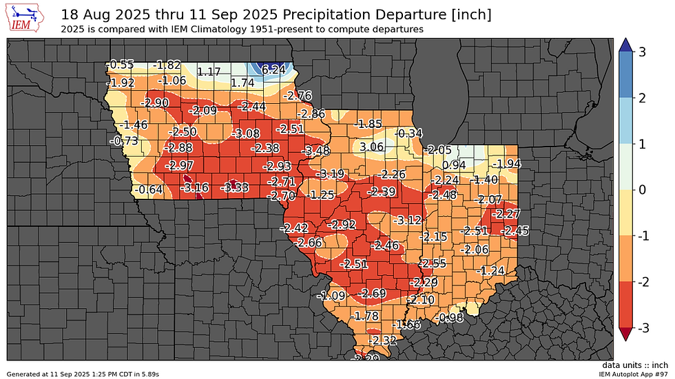
Here's the rainfall deficits that have accumulated over the past 24 days, some as high as 3.48 inches near the Quad Cities. Departures of 2.50 to 3.00" are widespread over southern Iowa and much of central Illinois.
That's a radical change from July 1st to August 15th when my area measured rain surpluses of 5–13 inches, with a number of cities in Iowa seeing their wettest July ever.

After drought conditions were all but eliminated around the heartland August 5th (see the panel on the right below), abnormally dry conditions have spread into my southern counties in SE Iowa and WC Illinois, as shown on the panel to the left. Moderate to severe drought has rapidly developed over southern Missouri and Illinois, and has been steadily progressing to the north. This trend of dry weather in late summer and fall has been going on for several years.

PLAN A VISIT TO MY 5 STAR GALENA AIRBNB

My 5-STAR AIRBNB just outside of Galena still has some fall openings. All of our ratings are 5 star! We take pride in the amenities and the cleanliness. If you book now, we'll take off $200, and we can eliminate AIRBNB fees and additional costs that will save you big bucks. Other discounts apply. Call or text Carolyn at 563-676-3320 for our best deal of summer. See more at https://www.littlewhitechurchgalena.com/
A LENGTHY STRETCH OF HEAT...
With topsoil moisture depleted due to several weeks of dry weather, that and the lack of a good moisture connection is going to set the region up for well above normal temperatures that, once established this weekend, should last through much of next week. One interesting aspect of the temperature forecast is tied to a problem the GFS has with too much mixing at low levels of the atmosphere. Overdoing it is causing the GFS to over forecast high temperatures by 5–10 degrees. Here's an example. These are the temperatures the GFS suggests in Keokuk over the next 2 weeks. It suggests 3 days of 100 degree heat, with a maximum of 103 Sunday. That's followed up by 4 more days in the mid to upper 90s.

The EURO, without the mixing issue, is having none of that, with a bunch of 90s but nothing hotter than 94 and a more general range of 90-93.

The bottom line is that it is going to get toasty, but nothing as extreme as what the GFS indicates. Additionally, with dew points aligned more to the low to mid 60s, the humidity will not be as obnoxious as other times this summer when dew points hit the upper 70s to low 80s. That is a big deal. The way it looks now, the heat index will only be a couple of degrees above the actual temperature and should not even reach the category necessary for a heat advisory. Here's what the EURO shows for the Quad Cities the next 2 weeks. 7 days of 90 degree highs in mid-September is pretty impressive, something the EURO didn't see coming a couple of days ago.

As you can see above, there should be a period where readings return to more seasonal levels around the 23 to the 25th. Preceding the cool-down, there should be a window when rain chances improve later next week, but that's too far down the line to speculate on at this time. The EURO is certainly not impressed by prospects showing these rainfall departures through the 26th.

I'll end with this, after the cool-off around the 23rd, the GFS shows the pattern reloading with the potential for another round of very temperatures to end September with a strong ridge and omega block developing.

These are the temperature departures shown on the GFS September 27th. That's a very warm look, assuming the trend verifies.

All right then, let's get this next round of heat started. Happy Friday and roll weather...TS


Comments