
DANGEROUS, HIGH IMPACT WEATHER...
I'M ASKING FOR YOUR ASSISTANCE... THE FUTURE OF THE SITE DEPENDS ON YOU . Hi everyone, as you know, TSwails.com is a no-pay site; existing on voluntary personal donations. Every year I ask those of you who find value in the site to make a financial donation you feel is worthy. Please reflect on the number of times you have visited us in the last year. If the information or knowledge you gained was valuable, it's my hope you will join the loyal group of contributors that's k


UPDATE ON SNOW TONIGHT
I'M ASKING FOR YOUR ASSISTANCE... THE FUTURE OF THE SITE DEPENDS ON YOU . Hi everyone, as you know, TSwails.com is a no-pay site; existing on voluntary personal donations. Every year I ask those of you who find value in the site to make a financial donation you feel is worthy. Please reflect on the number of times you have visited us in the last year. If the information or knowledge you gained was valuable, it's my hope you will join the loyal group of contributors that's k


SNOW, COLD, & PAIN...
I'M ASKING FOR YOUR ASSISTANCE... THE FUTURE OF THE SITE DEPENDS ON YOU . Hi everyone, as you know, TSwails.com is a no-pay site; existing on voluntary personal donations. Every year I ask those of you who find value in the site to make a financial donation you feel is worthy. Please reflect on the number of times you have visited us in the last year. If the information or knowledge you gained was valuable, it's my hope you will join the loyal group of contributors that's k


WINTER PATTERN GETTING LOCKED AND LOADED
I'M ASKING FOR YOUR ASSISTANCE... THE FUTURE OF THE SITE DEPENDS ON YOU . Hi everyone, as you know TSwails.com is a no-pay site; existing on voluntary personal donations. Every year I ask those of you who find value in the site to make a financial donation you feel is worthy. Please reflect on the number of times you have visited us in the last year. If the information or knowledge you gained was valuable, it's my hope you will join the loyal group of contributors that's ke


THE WINTER HITS MAY JUST BE GETTING STARTED
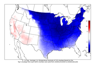
A snowy and cold few days across the region will likely be just the beginning of a wintry pattern taking over the second half of January. Analogs (above) are indicating a high confidence in below-normal temperatures as a conveyor belt of clippers and cold air from the northwest spill into the Great Lakes and Midwest. Temperature anomalies will likely be 10-15° below normal in due time, with the coldest air arriving starting late week into the weekend. The analogs are also sig


