SUMMER STILL HANGING ON....
- rebeccakopelman
- Sep 18, 2017
- 1 min read
We finally got rain this weekend - breaking a streak in my local area of 19 straight days of zero rainfall. Rainfall totals were light in most areas, but something is better than nothing! Behind the rain, a dose of fall moved in for Sunday and Monday.

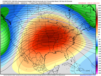
Warm air is already starting to fight back into the Midwest. The pattern is flipping once again and the trough that was over the Midwest will be replaced by a ridge.

At the surface a cold front will stall out and keep warmth and moisture pumping in to the Midwest this week.

That means warmth! And the flow is coming more out of the south which will also lead to increased humidity. First let's look at the high temperatures for Tuesday, Wednesday and Thursday:


The 40 and 50 degree dew points of Sunday and Monday will be replaced by upper 60s and even 70s by the middle of the week. Here are the expected dew points for Tuesday, Wednesday and Thursday:


The warm pattern will hold all the way through the upcoming weekend. Despite the higher dew points (and subsequent added moisture in the air) rain chances remain low. The higher chances for rain this week will be along the aforementioned front. Here's the next five days on the GFS (including some rain that fell Monday night):

The Fall Equinox is on Friday but summer is hanging on a little bit longer. On top of that September is likely going to end up warmer than August - especially after this week long stretch of summer weather!
RK


Comments