


SPOOKY TIMES, MORE ON THE WAY?
Welcome to November, a month that's started the way October ended...chilly. In fact, Halloween day was one of the coldest on record across much of my area. As you can see below in the graphic from the NWS in the Quad Cities, much of my area ranked anywhere from 2nd to 9th on the all-time coldest list. How spooky is that?

Despite the cold at the end of the month October ended up warm and wet around eastern Iowa. Temperatures were 2-4 degrees above normal while rainfall was 1 to 3.5" above normal.

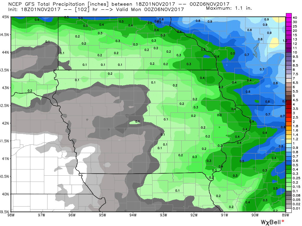
Moving forward, there are a couple of interesting things to focus on. The first is a warm-up that's slated for the second half of the coming weekend. Low pressure will travel northeast across the Midwest Saturday night and Sunday. It will generate a warm front that's expected to bring some rain Friday night or early Saturday as it enters Iowa. After a break later Saturday and much of Saturday night, it's followed by a cold front that should kick up some additional showers (and perhaps a few t/storms) Sunday as it advances to the east. Between the 2 windows of rain potential, here's what the models indicate for total precipitation.
The EURO:

A larger perspective.

Now the GFS.
I mentioned the warm-up Sunday and if you buy into the models it could be a biggie. Just look at what the GFS does for highs on Sunday afternoon. 70's all the way to Cedar Rapids and southeast Iowa. On the other end of the state it's only in the mid 40s!

The EURO is not as aggressive with the warmth. It just catches the SE tip of Iowa with the 70s and keeps Cedar Rapids at 61.

While either solution could verify there are some factors that could change the outcome such as the speed of the front. If it's a few hours quicker that cuts back on the warmth. If there's more cloud cover (or even some rain) that would also hinder the warming potential. Since its October and the days are short and the sun not nearly as strong as it was a couple months ago, that alone makes me lean more to the cooler EURO. Even it could be a few degrees too warm in my area if the other factors I mentioned come into play. So while I think Sunday will be a mild day I am playing it cooler until I have stronger evidence of the blow torch highs the GFS is showing in my local area.
Back to the cold front, it blasts through the Midwest Sunday night and early next week a massive 1034 mb Canadian high descends on North Dakota. That will bring a shallow layer of cold air off the snow cover in Canada and the upper Midwest deep into the central U.S. This is intriguing because it brings into play the potential for some snow or snow showers.

Here's how it could happen. Along the southern periphery of the cold air a boundary will set up and allow a wave of energy to propagate east along it. How amplified the wave becomes will determine where and how much over-running precipitation can develop north of the boundary in the cold air. This is big because both the GFS and EURO show thermal profiles cold enough for a narrow band of wet snow somewhere over the central Midwest.
The aforementioned wave looks like this crossing Nebraska on the EURO EPS control.

Below you can see a sheared out low pressure over Oklahoma. That would be the surface feature to watch with regards to any snow potential.

Since it's very early in the game and the energy is not well sampled I won't even show any snowfall forecasts. Some things are going to have to happen before this becomes an issue for anybody in the Midwest. Even at the worst, I'm not seeing much more than an inch. Something to keep and eye on going forward. Roll weather...TS


