


BLIZZARD, TORNADOES, THUNDER... OH MY!
- Jan 21, 2018
- 2 min read
A strong winter storm is moving through the Central U.S. and has brought spring-like weather to much of the southern part of the country.

The warmth and instability with this storm produced severe thunderstorms in Texas and Oklahoma and even led to the first Tornado Watch of the year to be issued.

That Tornado Watch (in yellow in OK/TX/AR) is just about 300 miles away from Blizzard Warnings -- an impressive spring-like set up in January! The storm will go on to produce blizzard conditions in portions of Kansas, Nebraska, Iowa and Minnesota Sunday night into Monday. Showers and thunderstorms will occur to the southeast in Iowa, Illinois and Missouri.
Here's a projection of the hi-resolution NAM Sunday night through Monday -

Let's talk the blizzard side first -- Heavy snow will be accompanied by 20-40 mph winds which will make travel difficult in Nebraska, northwestern Iowa and southern Minnesota late Sunday into Monday. Here's a look at the snowfall totals projected through Monday evening:


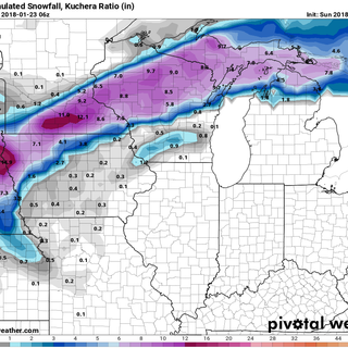


The NAM is the one outlier (further south) but otherwise there is good consistency on the track and the amounts. Where those Blizzard Warnings are totals of 12 to 18 inches of snow will be likely. There could be some isolated totals around 20". Those high amounts coupled with the strong winds will likely lead to white-out conditions and slick travel.
Then there's the other side of the storm -- the spring side.

There will be a big temperature range from 20s in the Dakotas to 60s in Illinois. There will be enough instability for thunderstorms to develop in southeastern Iowa and Illinois. Not incredibly high convective available potential energy (instability) but enough for storms to pop in January.

The potential for thunderstorms will exist through the day, but Monday afternoon (around noon-4pm) there will be the potential for strong storms. The highest potential for strong storms will be in western Illinois where some storms could produce gusty winds and small hail.
Due to the dynamics and the proximity to the area of low pressure, an isolated, weak tornado cannot be totally ruled out. However the chances are very, very low. Here's a snapshot of the hi-resolution NAM Monday afternoon to see the isolated cells popping in Illinois.

And there will be some periods of heavy rain in my area. And it will likely be the biggest rain in my local area in well over a year! Check out the rainfall totals on the GFS:

This is a pretty complex set up with a strong storm and multiple facets. Winds will be picking up through the day and slightly cooler air moves in for the middle of the week.
RK


Comments