THE FIRST DAY OF WINTER....
Today is the winter solstice, the first day of winter. Yippee! Technically it doesn't begin until the solstice occurs at 4:23 pm on this the day when we see the least amount of possible sunshine. In other words, the sun rises late and sets early. During the winter solstice, the Earth's axis is tilted at its farthest point from the sun, 23.5 degrees. While we're actually about as close to the Sun as we typically get each year, it is the low sun angle and short days that cause this time of year to be colder than summer.

To be honest, winter is coming in like a lamb. Even with colder temperatures today, highs will still be a few degrees above normal. Throw in some afternoon sunshine and you have a respectable day, especially considering what can happen at this time of year.
I'm still watching the potential for some light snow early Christmas day in parts of the central Midwest but models are not in sync on timing and location. They are in agreement moisture and forcing is going to be limited and amounts (if any) look very light in any given spot. As of Thursday night, the worst case scenario appears to be a dusting and I wouldn't even bet on that. All in all, I'm not very enthusiastic about prospects.
A potentially much bigger event comes after Christmas when a formidable chunk of energy emerges from the southwest. A moisture laden system is shown tracking across the Midwest December 26th-27th. Here's what it looks like on the GFS

It will be a wind maker with plenty of precipitation. PWAT's (available water vapor) have been coming in over an inch as far north as Iowa. That is near all-time record levels for December 27th.

As a result, heavy rains are a concern where they fall southeast of the storm. Thunderstorms are even a possibility. Here's the total precipitation shown by the GFS.

The EURO is not as bullish in my area with a more westward track of the surface low.

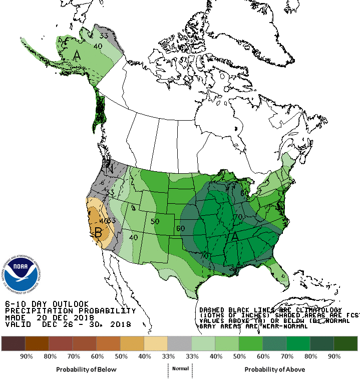
The Climate Prediction Center shows better than a 70% chance of heavy precipitation in the 6-10 day period which includes this storm.

Snow will also by a by-product of the system in the cold northwestern sector. The GFS has this for total snowfall early in the game. South Dakota and Minnesota taking the brunt of the snow.

The EURO as mentioned has a track NW that pushes the heavier snow in that direction. A sifnificant difference between the GFS and EURO.

Before I go, I was just getting ready to send this post and the new GFS has gone rogue. It does not phase the big system as much or as soon. This changes many aspects of the system including track, precip. amounts, and even type. So far no other models are showing this development, including the latest EURO. Sometimes you just get a bad run and the next one reverts back to the original solution. I have serious doubts about what the GFS is doing. I'm staying the course. We'll see what the new data delivers Friday. I'm shaking my head on this. Roll weather...TS


