


THE PATTERN GETS STORMY ONCE AGAIN...
- Mar 7, 2019
- 2 min read
If you needed one more thing to be proud of this winter you can add an all-time record Illinois low to the list. The NWS recently confirmed that the low of 38 below January 31st in Mt. Carroll, broke the previous state record of 36 below in Congerville from January 5th, 1999. A big pat on the back to my friends over in Carroll, County!

On a more serious note, the last 2 posts I've been talking about the potential for a significant snow melt flood this spring. One of the rivers I mentioned as having an enhanced risk was the Mississippi. Today the NWS confirmed that concern by issuing new long range threat outlooks. In the graphic below you every purple station on the Mississippi from Dubuque to near Keokuk has a 100% chance of reaching at least major flood stage. It may have happened before but I don't ever remember seeing it. That is a very concerning forecast. Obviously there is high confidence for numbers like that!
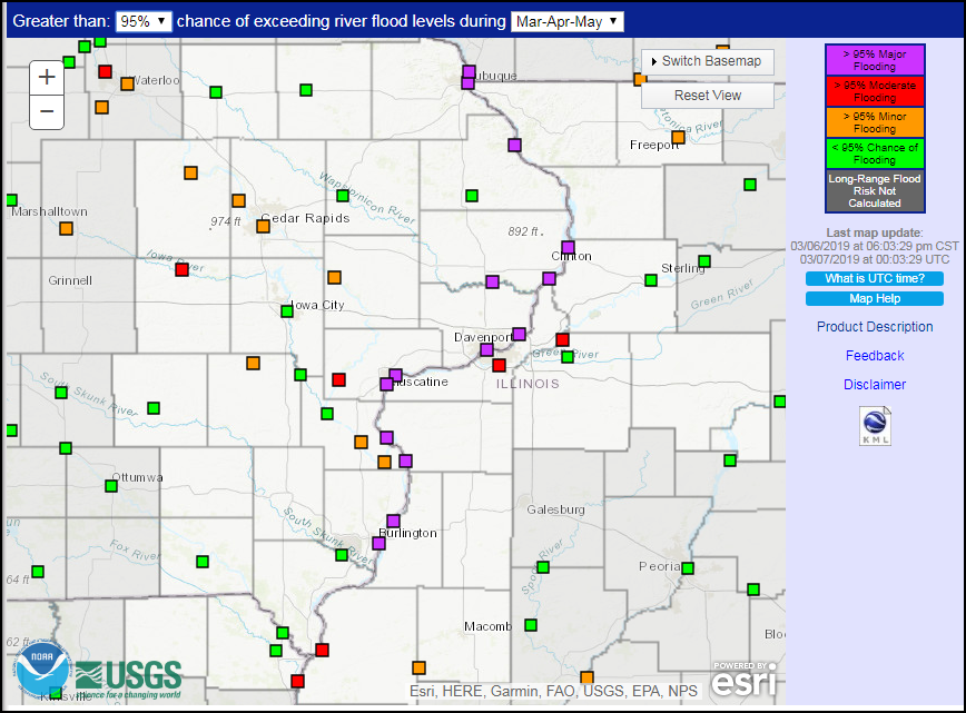
The Cedar River in Cedar Falls and Cedar Rapids also have high assessments with 65% chances of major crests in those communities.
That is why the long term forecasts are not welcome news. They show 2 major storms the next 10 days with widespread heavy precipitation that will only increase the flood risk. The Weather Prediction Center shows totals of 1 to 3 inches the next 7 days across the Midwest, 2 to 3" from the Mississippi west.

The EURO has this.

The GFS shows this.

While there is a little snow in the forecast Thursday it doesn't appear that it will amount to much. The latest snowfall forecasts are certainly not impressive for my local area.
Here's the NAM

The 3k NAM

The GFS

Due to some potential slick spots, the NWS does have winter weather advisories out for the counties in blue.

A much larger and more important storm rolls across the Midwest Saturday. This disturbance has much stronger dynamics and a connection to rich moisture. It will have a snowy side to its northwest as well as a springlike side to the southeast. The precise track is still in question but by all accounts my area will be in the western fringe of the warm sector meaning the majority of the precipitation here will fall as rain.
The EURO shows the storm in this position Saturday evening at 6:00pm

Here's precipitation type. More heavy snow just to my northwest, exactly where it's least wanted.

It remains to be seen what this will do in terms of initiating the flooding process. I doubt much of the deep snow up north will melt and in many cases it will increase even more. For that reason the Mississippi will not be in play yet. In fact, I doubt there is any major crest on it until well into April.
However, other places further south could see rises on rivers and streams due to rainfall and snow melt. These are not likely to be significant but it could get the ball rolling for what's possible later this month. We'll need to keep an eye on it. Roll weather...TS


Comments