WAITING FOR SIXTY...
- terryswails1
- Mar 25, 2019
- 2 min read
Here we are down to the last days of March and we've yet to see a 60 degree day. The last one in Cedar Rapids occurred October 30th. That means Tuesday will be the 146th consecutive day without a 60 degree high. That puts us 19 days from the all-time record of 165 set in 1974/75. If all goes well, the streak could come to an end Wednesday when highs of 60 have a good chance of reaching as far north as Minneapolis.

A closer view of my area.

If we don't get the job done Wednesday or Thursday, it could be awhile before our next opportunity. The reason why is the direction of the EPO (Eastern Pacific Oscillation). The EURO shows it going strongly negative by the weekend and staying there for an extended period of time, roughly through April 20th.

The graphic below shows the temperature anomalies associated with the negative phase of the EPO in both March and April. Not the trend most of us want to see.

Here's the upper air pattern the negative phase is known to produce favoring below normal temperatures.

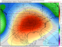
You can certainly see the projected 500mb jet stream pattern below resembles the negative EPO look on April 2nd.

The 5 to 10 day temperature departures look like this March 30th to April 4th. Yuk.

The next storm which brings a wet start to the weekend appears to be a significant precipitation producer as well. The Weather Prediction Center indicates this for precipitation the next 7 days. There's even a chance that some areas could see a change to snow Friday night or Saturday before the storm comes to an end. I'll dig deeper into that in my next post.

Until then, roll weather...TS


Comments