


I'M MELTING!...AND FAST
Experts are claiming that Greenland lost 2 billion tons of ice due to melting Thursday. The big thaw was blamed on a persistent blocking ridge of high pressure that pumped warm humid air into Greenland all the way from the central Atlantic.

If you're wondering how much 2 billion tons of ice really is, one scientist from Columbia University indicated it would stack up to be 8 times higher than the Washington Monument (555 feet high).

Interestingly, the melt is tied to the breakdown of the persistent ridge of high pressure that had been in place over the southeast U.S. most of the winter and spring. Its recent eastward shift into the Atlantic recently allowed the axis of warmth and humidity to take aim on Greenland. You can see the reds over Greenland depicting above normal heights and warmth there. The blue depicts below normal 500mb heights and temperatures centered over the eastern U.S.

Over the next few days little change is expected in the overall pattern. However, there are subtle events going on that are expected to bring a period of higher heat and humidity to the Midwest the end of the month. Note the changes in the 500mb flow as the EURO develops a significant ridge over the midsection June 29th.

Here are the associated temperature departures. Steamy conditions streaming into the Midwest.

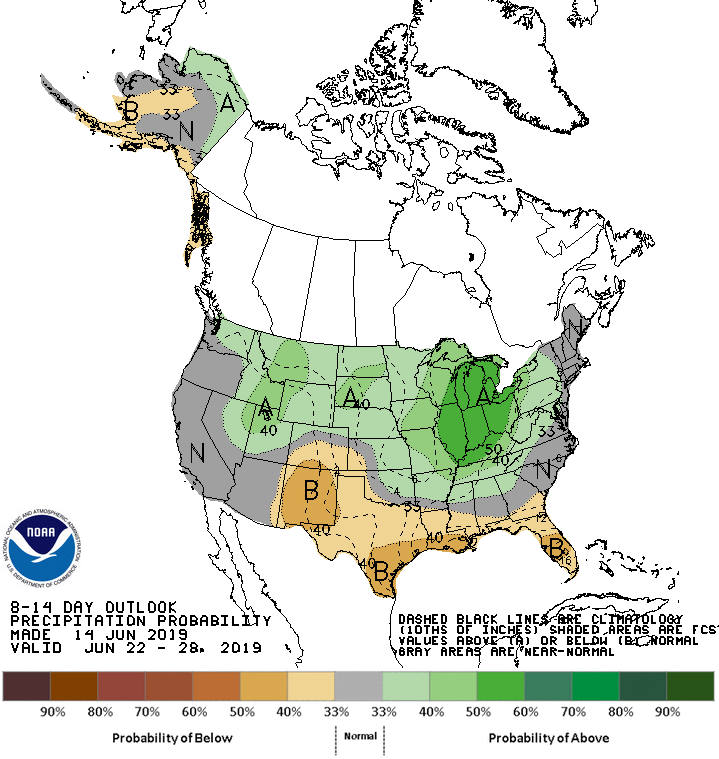
The Climate Prediction Center is sensing the trend showing this for temperatures in the 8-14 outlook June 22-29th). The warmer air is creeping further and further northwest

If the pattern evolves as expected in the long range, the scene would be set for ring of fire thunderstorms to develop on the northern periphery of the heat. These are generally nocturnal in nature but can be severe weather and heavy rain producers. The Climate Prediction Center shows the return of heavier precipitation to much of the corn belt in the 8-14 day period.
The EURO EPS ensemble mean does show ample precipitation over the next 15 days, much of it coming in the second half of the period.

The weekend ahead is expected to have plenty of good moments. Temperatures will be near normal meaning highs around 80 both Saturday and Sunday. The best opportunity for precipitation comes late Saturday afternoon or Saturday night as a front arrives from the northwest. A few strong storms are a possibility with the south most at risk for the heavier storms.
The forcing for rain is largely gone by Sunday so Father's Day should be dry and mild in my area. Here's wishing my dad and hero (as well as all you other father's out there) a fantastic day! Roll weather...TS


