


SHOW ME SOME SUMMER...
Friday was the first day of summer and by all accounts it was a miserable one over much of the area. Nearly an inch of rain fell in Cedar Rapids accompanied by a high of 67 (normal is 82). This is part of a 12 day stretch of cool damp weather where the average high has been 74 degrees here. Only one out of the last 12 days has the high reached 80 (that was 80 the 15th) and two days readings didn't even get out of the 60s. Come on! Here's the temperature departures for the past 14 days.

These are the monthly temperatures in Cedar Rapids. This does not show the 67 degree high registered Friday.

As you can see in the graphic below from the Iowa Mesonet, many places in the central U.S. have had up to 8 less 80 degree days than would be expected at this point in the year.

The cool weather is also the by-product of the wet conditions that have plagued the Midwest for months. Just look at the number of flood warning days this year. 138 from the NWS in the Quad Cities. Most of these have occurred since mid-March.

While I do see a week long warm-up June 25-July 2nd, I suspect its just a temporary trend. For several months I've been projecting summer to be cooler and wetter than normal. I see no need to change that outlook now. In fact, I was looking at the EURO weeklies which extend out to early August and they certainly confirm my thinking.
The control shows much of my area picking up another 10-15" of rain in the next 6 weeks (out to August 5th).

Here's the associated anomalies.

Rain and wet soil conditions are big contributors to cool temperatures. The weeklies have this for 46 day temperature departures, again out to August 5th.

The CFSv2 (U.S. climate based model) shows the wet pattern June-August over the Midwest.

However, it also shows temperatures above normal over most of North America. I have some issues with that. Prove me wrong CFSv2.

Circling back to the weekend, we still have some rain to deal with as our slow moving storm grinds its way across the Midwest. While the threat of showers and storm exists through Sunday night, there are going to be plenty of dry hours for outdoor activities. In this type of pattern, the most likely time for storms is late in the day (at peak heating) or during the overnight hours when the low level jet can enhance activity. As moisture increases the potential for heavy rains will also go up. The Weather Prediction Center shows many areas receiving another 1-2" of rain before it comes to an end Monday. Where heavier storms train some 3-4" totals are possible.

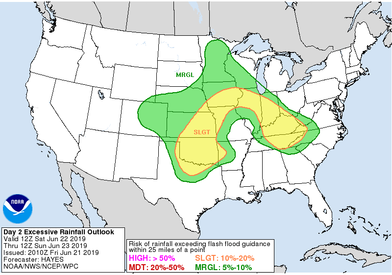
WPC also shows slight risks for excessive rains both Saturday and Sunday. Here's the current outlook for Saturday.
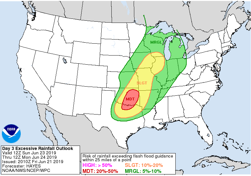
And here's Sunday's outlook.
Humidity (and to some degree temperatures) will go up over the weekend but the real steamy conditions are now expected to hold from about the Iowa border on to the south. The weekend will be far from perfect but it should have some decent periods.
Myself, I'm on my way to Portland, Maine with my family to attend a weather conference next week. Looking forward to eating some fresh seafood. Hopefully I don't freeze while I'm doing it! I'll send back pictures. Until then, roll weather...TS


