


WELCOME TO NOVEMBER...
- Nov 1, 2019
- 3 min read
Welcome to November! We all know It gets cold this time of year but this chill is out of the ordinary. The high in Cedar Rapids Halloween day reached a paltry 31 degrees thanks to a mantle of fresh snow. Regarding that snow, outside of the far north and west, most of my area had a good 2-7" of the white stuff, good enough for record or near record October snowfall.
There's no doubt the next 8-14 days are going to stay on the chilly side as NW flow dominates the North American weather pattern. Breaking it down into 5 day increments these are the forecast temperature departures.
Days 0-5

Days 5-10

Days 10-15

This period also looks to be less stormy with lighter precipitation than what we've seen the past couple of months.
The GEFS ensembles show much of the country with below normal precipitation the next 16 days. Some of the driest weather is over the central and upper portions of the Midwest where farmers can really use it.

There's even more good news for those of you not ready for winter just yet. Here's the EPO forecasts from both models. The EURO first.

And now the GEFS, not quite as bullish on the climb as the EURO but it too makes a nice upwards move.

What this spike could signify is that the ridge over the NW is showing signs of breaking down mid to late November. Even if this is temporary it would make a significant difference in temperatures for a time with modified Pacific air instead of the early season Arctic air we are in now. This is today's 500mb flow. See the ridge in the bright reds over the northwest. That's an open door for cold air to enter the Midwest.
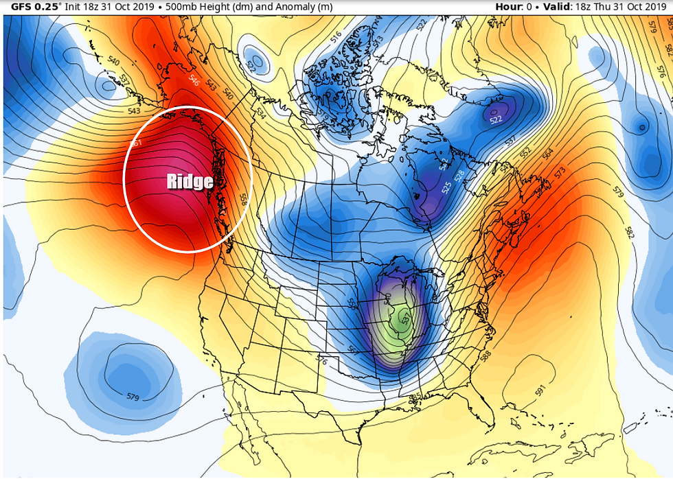
Now look at day 16, the reds have been replaced with blues indicating some troughing splitting the ridge. That changes the source region of our air masses.

If indeed this happens, I doubt the mild pattern lasts overly long with the way sea surface temperatures are aligned in the Pacific. In fact the EURO MJO shows the warming as it slips into phase 6 but by the end of the cycle it's already going into phase 7 which is cold in November. Here's what the MJO cycle looks like October 31st to November 14th. Follow the dotted green lines. The last dot is November 14th

These are the phase correlations to temperature and precipitation. Phase 5 is cold, phase 6 a big warm-up, phase 7 back to cold. You'll also notice phase 5 and 6 are dry ones on the Midwest. Phase 7 not so much.

We'll keep tabs on this in coming days. Meantime the weekend will be chilly with highs mid 30s Friday and Saturday, perhaps upper 30s to near 40 Sunday. 15 to 20 below normal. There is a chance for a few rain or snow showers Friday afternoon but they will be brief and light, no big deal. A few more are possible in the north Sunday afternoon. Well, that's a wrap for this post. If you haven't subscribed please give it some thought and read the next paragraph. Have a great weekend and roll weather...TS
P.S. Fund raising is ongoing to allow TSwails to grow into one of the best, most unique and reliable weather sites in the Midwest. We ask you to consider a voluntary subscription fee of $12 dollars a year, $1 dollar a month. It allows me to stay free of the corporate world and do what I do best. We hope you see the value and hard work that goes into the site everyday. Your support in any way is tremendously appreciated. Thanks and roll weather. To donate click on the secure green box below.


Comments