


THE KEY TO THE WINTER AHEAD...
- terryswails1
- Nov 14, 2019
- 4 min read

I've been trying to get a handle on the long range pattern the past few days and I can tell you I'm challenged.Two of the big teleconnective drivers I look at to determine trends are the MJO and the EPO. I'm getting some conflicting signals. Let's start with the MJO.
The MJO (Madden Julien Oscillation) is essentially tied to waves of convective energy (thunderstorm clusters) that travel through the tropical Pacific. The location of the convection and time of year has been correlated to storm tracks and weather patterns over North America. There are 8 phases and models on a daily basis forecast the track of the MJO through them based on how that convective energy behaves. There are enhanced phases which can be stormy and suppressed ones which are not. These also have strong relationships to temperatures.

Since late October when this record breaking cold and snowy pattern began, we've gone from phase 2 through 3, 4, 5, 6, and now phase 7. Outside of phase 7 (which we've only been in for 3 days) these are generally known as mild temperature producers. Below you can see the daily MJO progression from October 28th to November 12th.

Now here's the phase correlations with regards to temperature. Not much in the way of below normal temperatures with these 4 phases.

So what have we proved here? That if you looked at the MJO for guidance 2-3 weeks ago you would have never expected to see the cold we just experienced. Just look at the departures over the past 14 days. Don't see any of that indicated in those diagrams.

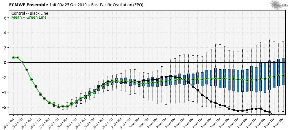
What this tells me is that something else is driving the bus and that's where the EPO (eastern Pacific Oscillation) comes into play. The EPO is a weather pattern in the eastern Pacific with only 2 phases, one negative and the other positive. In the negative phase pressures are higher in the north Pacific and that corresponds to widespread cooling over the eastern 2/3rds of North America. The phase of the EPO becomes important during winter because the negative phase of the pattern opens the door to very cold Arctic and Siberian air to enter the US. Bingo!

So here you go, this is how the EPO has performed since October 25th. Strongly negative, especially around October 29th and again towards Nov. 9th and 10th when it dove more than 5 standard deviations below the mean.
Simply put, the EPO is out muscling the MJO and driving the pattern. Why you ask? Well, I'm not certain but I do think it has to do with the very warm sea surface temperatures in the north Pacific. We've talked about them before and referenced them as the blob. Can't miss the warmth just south of Alaska

That sea surface temperature anomaly is not projected to change much during the next 3 months so it goes to figure that with no La Nina or El Nino, the EPO should continue to be the key to look at with regards to our winter, especially temperatures. I also think that if you get the EPO in a negative state and the MJO in cold phases, you have the potential for some big time cold....perhaps a stratospheric warming and a visit from the polar vortex!
Jumping ahead to the future, most models are now showing the EPO making some sort of push into positive territory in the next week. The EURO ensembles show that trend from the 17th through the 25th (and beyond).

That should make for a more seasonal brand of weather with the potential for "dare I say", some slightly above normal temperatures by Thanksgiving. The EURO has this for 5 day departures November 18-23rd.

With regards to the EPO going positive, I wish I had the answer to what is causing the change. The MJO is not really an obvious factor as it shows the Midwest in cool phases the next week or so before some members stick it into the null phase by the end of November. That would imply little MJO influence in the overall pattern.

The EPO popping positive is bugging me but short respites are common, particularly after an anomalous period of cold such as this. But rest assured, if the EPO goes neutral (and especially positive), that cuts the Arctic air out of the equation as far as the central U.S. is concerned and we moderate. My hunch based on the reasons I gave your earlier, is this is just a short term trend and we see the EPO fall and we get back to winter by early December. But as it stands now, it appears we are in for a calmer, gentler brand of weather in the 5 to 15 day period. Nothing like a breather. Roll weather.
PLEASE CONSIDER THE VALUE...
I hope you are aware of how far ahead of the competition TSwails has been in catching the trends of our early winter weather pattern. It takes a heck of a lot of commitment, passion, and knowledge to do that. This is now my job and that's why I'm asking for a voluntary subscription fee of $12 dollars a year, one dollar a month to keep TSwails going. Together we can create one of the best, most unique, and reliable weather sites in the Midwest. Your contribution of 3 cents a day, allows me to stay free of the corporate world and pour my energy into doing what I do best, forecasting the weather! We hope you see the value and hard work that goes into the site everyday. You support in any way is sincerely appreciated. Thanks and roll weather. To donate click on the secure green box below.


Comments