


BY THE HAIR OF MY CHINNY CHIN CHIN, BRUSH WITH A BIG SNOW...
After a quiet storm free free day Saturday, attention turns to the winter storm that will impact parts of the Midwest late Saturday night and into parts of the day Sunday. There are still some small but important differences in track and that will make a big difference in how much snow falls in my area, especially across the north.
As you can see in the graphic below the EURO (and most of the hi-res models) are further north with the surface low passing close to HWY 20. The GFS and Canadian GEM take a path closer to HWY 30.
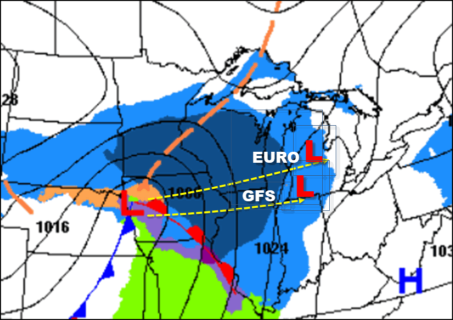
It's not a big difference but that 35-50 mile spread will determine how far south the significant snow gets into my area. When it comes down to making a choice between the GFS and the EURO there really is no choice...I'm a EURO man when money is on the line. That doesn't mean I'll be right but the skill scores of the EURO are significantly better for a reason and that is the sword I will die on.
Siding with the EURO below this is what I'm roughly expecting for snow totals. The worst of it bypasses all but my far northern counties.

Here's a closer look at my area.

By comparison this is the GFS snowfall forecast, You can see those pinks extend a couple counties further south (roughly 60 miles). That brings the snow further south into my central counties, mainly near and north of HWY 30. I doubt it.

It's also interesting to note the sharp cut off line to the southern edge of the snow. The warm advection wing of forcing is laid out west to east meaning the southern half to 2/3rds of my area, south of the primary snow band will only see minimal amounts of snow. In fact, some rain may mix in before the dry slot kills any precip south of HWY 20 in the morning. Liquid precipitation totals south of HWY 30 should not be much more than 1/10th of an inch. However, well north of HWY 20 they are pushing 7/10ths, substantially more and primarily in the form of snow.
As it stands now amounts near and south of I-80 will be minimal. Some models do show a surge of moisture arriving from the south, combining with the primary band to the north converging right over eastern Iowa or Illinois Sunday mid-day. How soon that merger occurs is important as it could add a little snow (perhaps an inch) to my eastern counties in Iowa and NW Illinois. Not a big deal but a fly in the ointment just the same.
Around HWY 30 the trend has been for snow totals near an inch., that might even be a push. Around HWY 20 the consensus is for amounts around 2 inches. Then the totals dramatically increase as you approach the Minnesota border.
I guess the exciting thing for me is that I am in Minneapolis, Minnesota where Carolyn, Eden, and I are celebrating Eden's "sweet 16" birthday. We are visiting the Mall of America Saturday, have a concert to attend Saturday night followed by a stay in a pretty swanky hotel That means along with Eden's special day, I will get to experience the snow up here which has prompted Winter Storm Warnings over much of southern Minnesota and extreme northern Iowa. The plans were made 2 months ago so this is a divine occurrence, What a great weekend for me! In fact, some of the models are showing up to a foot of snow by the time we leave Sunday. If that happens we may even stay another night rather than fight the roads. I plan to do some Facebook lives on the storm and will have more on that in later reports. From beautiful Minneapolis I say roll weather. and have a fantastic weekend..TS


