A WALL OF COLD, MORE TO COME...
A dramatic cold front brought a wall of cold air across my region Friday. At 1:00 pm temperatures ranged from 72 around St. Louis to 24 just west of Mason City in NC Iowa. While it was 60 in the Quad Cities a little over an hour away in Cedar Rapids it was 37. Ahhh...the fortunes of weather!

Many places behind the front were 30-40 degrees colder than just 24 hours earlier.

Light showers, and in some areas freezing rain and drizzle fell with a thin glaze on some elevated surfaces in the far north. Nothing serious. just enough to let a few of us know that April can be just as ugly as March. The rest of the weekend will be dry but cool, especially Saturday. Despite the addition of strong spring sunshine highs Saturday will struggle to reach the upper 40s to low 50s. Sunday will be better with most places 56-60.
After that I have good news and bad news. Starting with the good we've got a big warm-up slated for next Tuesday. Some places could see their first 80 degree high of the year (or at least very close). Here's what the EURO is advertising for highs.

Dew points are also projected to get into the 60s and pool ahead of a late day or early evening cold front. That yields some pretty decent CAPE (instability).

The potential is there for a few strong storms if things time out properly. That's the beginning of the bad news which is predicated by a prolonged period of below normal temperatures and even the potential for snow around much of the Midwest . To give you an idea of what's being advertised. This is the 500mb jet stream flow April 18th.
on the EURO control. A cross polar flow, That is a very chilly look for mid-April.

These are the temperature departures by then which are running 20-30 below normal.

And here's something I think is pretty impressive. It's the 850mb temperatures...about a mile up at 5,000 ft. The 0 isotherm is the level needed to get snow down to the ground. That is shown reaching all the way down into Texas, Mississippi, and NW Alabama. My area is -12 to -16. That is very cold air aloft. Combine that with the strong April sun which will try and warm the surface and you will have big lapse rates and a very unstable atmosphere. Even without an organized storm snow showers or squalls are a near certainty if this happens.

Several models actually develop a couple disturbances which could produce system snows with accumulations. There is no way at this distance to accurately pin-point where that might be but my confidence is growing that some part of the central Midwest will see a late season snow.
The latest EURO EPS ensemble had this for snow accumulations. This is the average of 52 members. Some have much more in my area. Others very little. The average over most of my area is 1-3" during the period April 13th- April 18th.

The EPS control spins up a significant storm that buries the southern half of my area. Put "no" faith in this solution. I only show it to give you an idea of what could happen in some part of the Midwest with the amount of cold showing and moisture that's available for storms in April. This is all hypothetical but within the realm of possibility. This is going to be a very interesting period of weather.

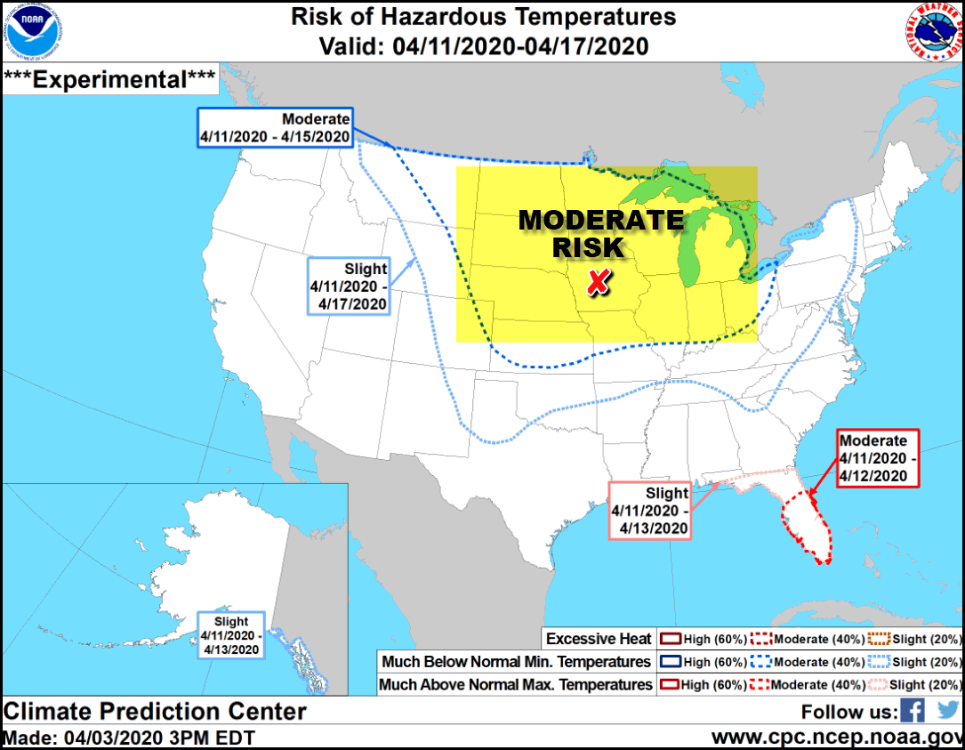
Before closing I will also add that the Climate Prediction Center has a large area of the central U.S. under a moderate risk of hazardous temperatures April 11-15th.

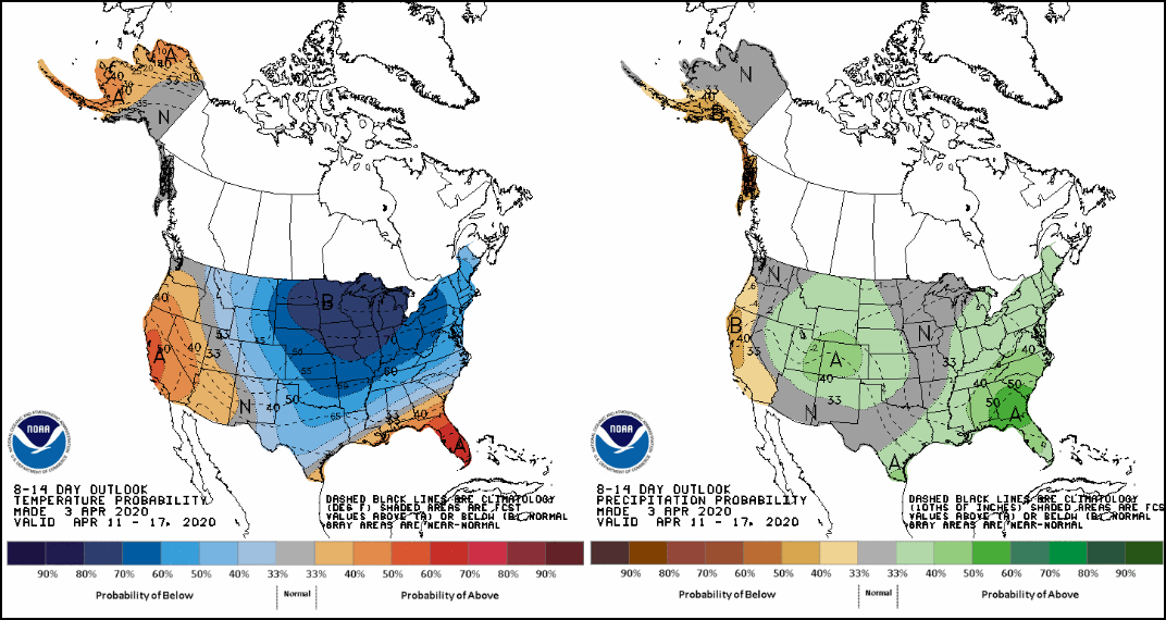
Here's the CPC 8-14 day temperature and precipitation outlook.

Well, I guess you get the idea. Meantime think about that warm day coming up next Tuesday. It will be one to savor.

Before I go, I also want to note the passing of Fran Riley a friend and co-worker from my days in the Quad Cities. He was a class act and a gentle and compassionate soul. His laugh could fill a room and his enthusiasm for life and concern for others will be his enduring memory. I am grateful to be a recipient of the joy he spread by simply being Fran. He will be missed by so many of us whose lives he touched in a positive way.
Roll weather...TS


