


THE FOUNDATION OF THE WINTER AHEAD...
I was poking around a bit today in the wide world of weather that I live in. I came upon the sea surface temperature anomalies over the tropical Pacific. This is something I start paying attention to in the mid-summer because invariably it plays a role (sometimes a big one) in the type of fall and winter the Midwest experiences. Note the cool waters that exist near the equator in the eastern Pacific.
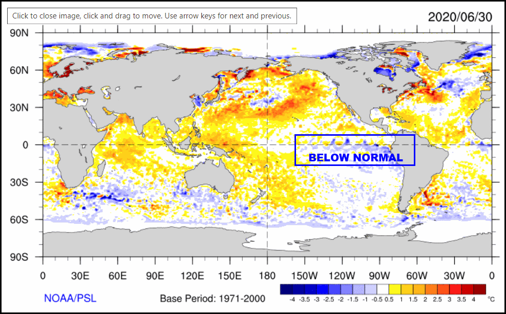
The cooling in that area has increased significantly in recent months and points to what could be a developing La Nina. The NCEP CFSv2 model forecasts a dip into weak or even moderate La Nina by winter.
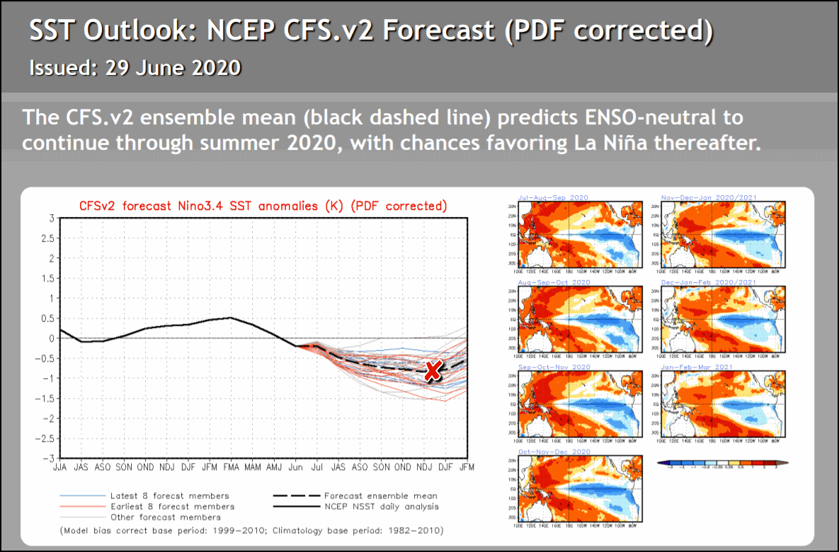
The mean of all the dynamical models also shows continued cooling in 3.4 by the time winter arrives again pointing towards La Nina.

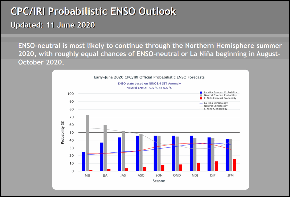
You can see that the probabilities of a La Nina winter (blue) are much higher than El Nino (red).
SO WHAT IS LA NINA AND WHY SHOULD I CARE?
La Nina refers to the periodic cooling of ocean surface temperatures in the central and east-central equatorial Pacific. Typically, La Nina events occur every 3 to 5 years or so, but on occasion can occur over successive years. La Nina represents the cool phase of the El Nino/Southern Oscillation (ENSO) cycle. La Nina began to show signs of strengthening this spring as negative temperature anomalies returned to the equatorial Pacific Ocean. Several computer models forecast this cooling to continue through the fall and winter.
During a La Nina event, the changes in Pacific Ocean temperatures affect the patterns of tropical rainfall from Indonesia to the west coast of South America. These changes in tropical rainfall patterns affect weather patterns throughout the world. These effects are usually strongest during the winter months when the jet stream is strongest over the United States. As you will see in the image below, La Nina episodes in the winter months feature a wave-like jet stream flow across the United States and Canada, which causes colder and stormier than average conditions across the North, and warmer and less stormier conditions across the south. Historically for the central Midwest, winter temperatures average close to normal while precipitation is near to slightly above the mean. However, there are also many other complicated factors in the atmosphere and oceans that can also impact how weather patterns turn out.

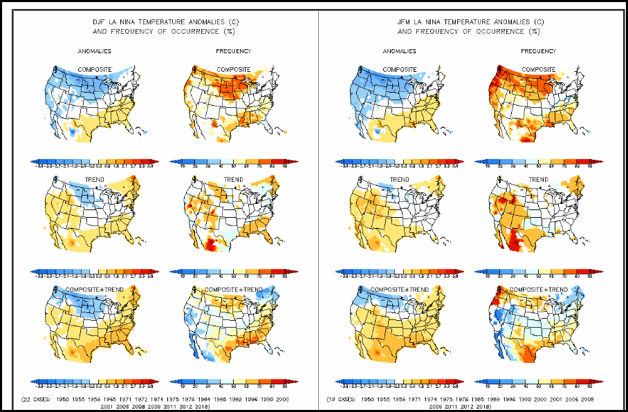
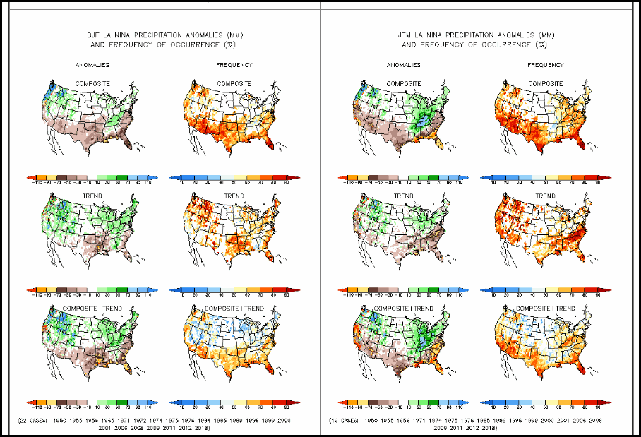
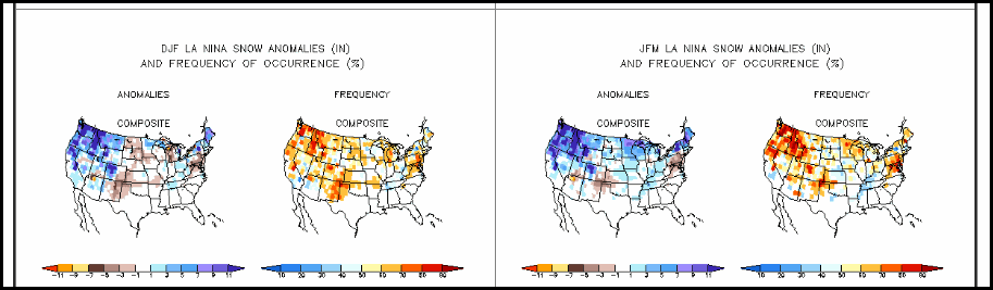
The images below show temperature, precipitation and snowfall anomalies across the continental United States (CONUS) based on past La Nina events dating back to 1950. Each image is comprised of an anomaly map on the left side and a frequency map on the right. The anomaly map shows the computed anomaly based on all past events. The frequency map on the right indicates how often these anomalies occurred. A high frequency leads to a higher confidence that the anomaly may occur again. The maps are further broke down by composite on the top, trends in the middle, and a combination of composite and trends on the bottom. The images on the left are for the period December-February (meteorological winter), and the images on the far right are for the January-March period (late winter into early spring). For our area, you can see that the temperature anomalies are close to zero, but the negative anomalies are just to our northwest. This is a reflection of some La Nina years being warmer than normal and others being colder than normal. Precipitation and snowfall anomalies for our area become wetter as we progress through the winter into the early spring, with a decent frequency of occurrence. Remember, these maps are based on past La Nina events alone and do not take into account other phenomena which can work with or against a La Nina pattern and impact our weather.
WINTER TEMPERATURE ANOMALIES
WINTER PRECIPITATION ANOMALIES
SNOWFALL ANOMALIES
Taken at face value, the weak to perhaps moderate La Nina that seems to be developing should produce a pretty typical winter for much of the central Midwest. The further north one goes, the more severe the winter tends to be. Wild cards such as the Arctic and North Atlantic oscillations as well as the Madden Julien Oscillation can alter the outcome but are not visible at this range. Needless to say, we are early in the game but I think this is a key card that could very well be the foundation of the winter to come.
Getting back to summer and the 4th of July, it looks like spotty rogue showers and storms will still dot parts of the region tomorrow as a stagnant upper air pattern rules for another day. Again, the rains will be very much hit and miss and most spots will stay dry. In general, warm muggy conditions will prevail the rest of the holiday weekend. While a stray afternoon storm is possible, they look few and far between and the stage is set for some typical 4th of July conditions. Make your plans outside. Roll weather...TS


