


SEVERE WEATHER THREAT TODAY...
- Aug 10, 2020
- 1 min read
Conditions will be favorable this afternoon and early evening for active thunderstorms with a significant threat for strong winds.in spots that have the potential to reach 60-80 mph in the strongest cells.Instability is already high and CAPE is expected to approach more than 4500 j/kg before the storms arrive.

The microburst composite index has already reached 10 indicating intense microbursts are likely.

By mid-afternoon the supercell composite index over the southern half of my area is around 12 indicating supercells are likely as well.

While some quick QLCS spin ups are possible, the overall tornado threat is low. However, SPC indicates a 70 percent chance of 10 or more severe wind events and and a 90 percent chance of 6 or more.

SPC also has much of my area in an enhanced risk of severe weather due to the wind threat.

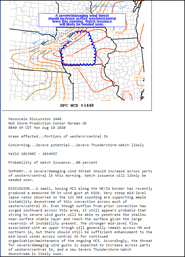
A severe thunderstorm watch is in effect over central Iowa and eventually will be issued for eastern Iowa and parts of Illinois later today.

This mesoscale discussion issued earlier focuses on the central Iowa potential. Conditions will likely be even more favorable over parts of my area later this afternoon.
Here is a radar image from 10:40 am showing strong storms approaching central Iowa. The appearance of bow echo characteristics are already evident.

Again, the potential is high for bowing segments and damaging winds later today. Keep en eye out for rapidly changing conditions and a weather watch over the next few hours. Roll weather...TS


Comments