


CALLING ALL RAIN DROPS...
You don't have to look further than your yard or garden to know that we need a good rain. While we closed the month out Monday with a meager shower that produced .03", it didn't even settle the dust. With August in the books the official August rain deficit in Cedar Rapids was calculated at 4.03" (4.48" is the monthly norm).
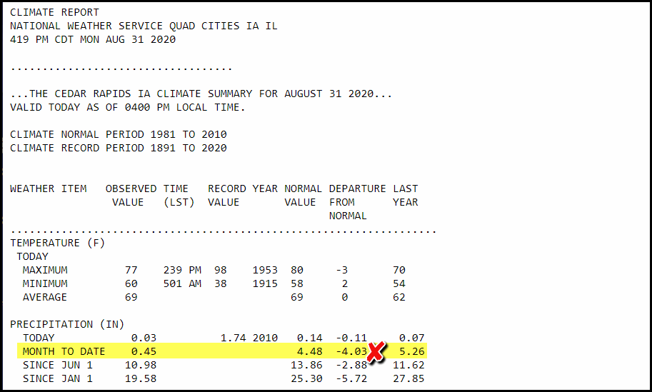
This years monthly total of 0.45" is mighty meager compared to last year when 5.26" filled the bucket. For the year we are now 2.88" below normal.
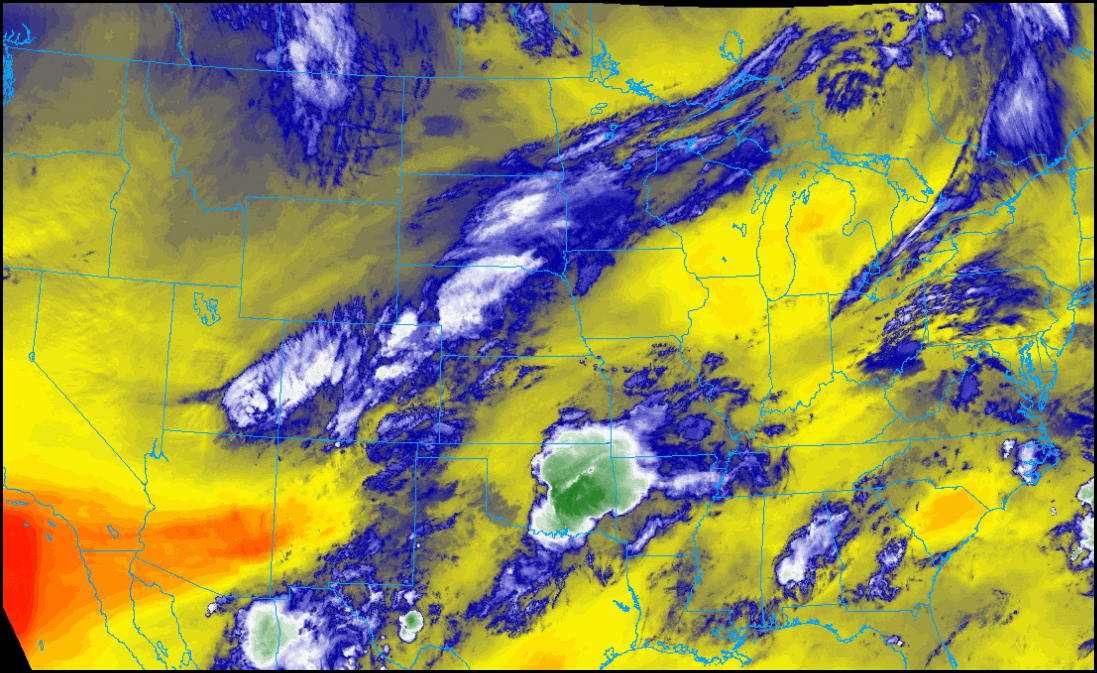
For many of you, I may have some good news to offer but it depends on where you live and which model ends up being correct. The opportunity stems from energy that ripples northeast along a stationary boundary over Missouri and central Illinois. The EURO develops a weak surface low and generates decent warm advection and a deformation band over the SE 2/3rds of my area. Rain is shown during the afternoon and evening. This is the EURO surface depiction of fronts and rain at 8:00 pm. The weak low is centered near Burlington.

The EURO has this for rain totals. If it's to be believed some parts of EC Iowa could pick up 1/2 to 1.00 inch. Amounts taper off fairly rapidly to the NW and SE of the main band.

The GFS is a less organized and that keeps the system further south and much lower. Far less impressive that the EURO. You can see its rain numbers below favoring the SE third of my area, especially from the Quad Cities southeast.

Based on the satellite imagery late Monday night I favor more of the EURO depiction. I'm sticking my neck out here that at least the southeast 2/3rds of my area will see some worthwhile rains. I say this full well knowing the old saying, in times of drought signs of precipitation don't pan out. I'm putting the hex on that! (hopefully)
By the way, temperatures Tuesday should be cool to start the new month with highs generally in the low 70s.
After this disturbance moves out, rain chances look limited until later in the weekend when a stout fall cold front arrives from the Canadian prairies. Before that temperatures look to bounce around a bit but generally will be on the pleasant side of warm. This is what the EURO is depicting over the next 10 days.

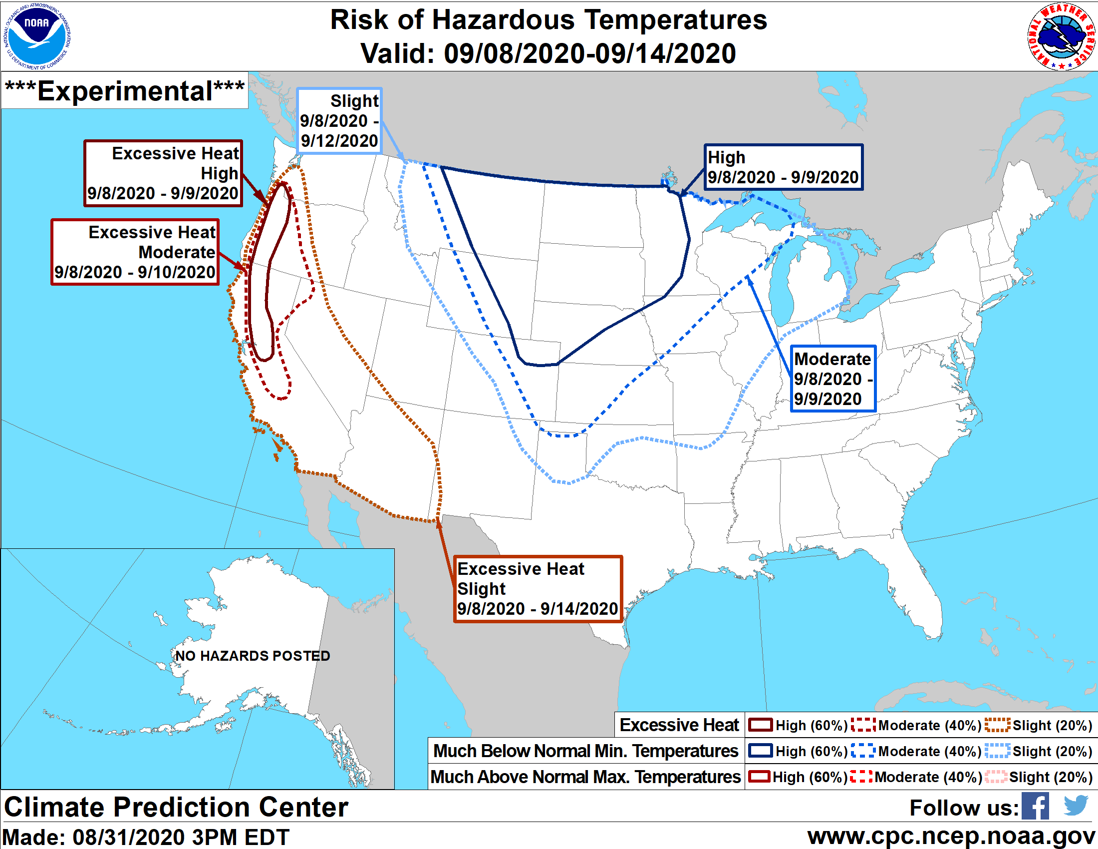
It's hard not to notice the arrival of much cooler air next week as highs crash from the mid 80s Saturday to the low 60s Thursday September 10th. As I was harping on last week, a big pattern change is in the works the second week of September as a very amplified ridge builds over the Pacific Northwest aided by a western Pacific typhoon. The downstream effects will be to carve a full latitude trough into the nations mid-section that looks like this.

Check out the temperature departures September 9th. Some 32 degrees below normal in Missouri.

Lows September 10th are well into the 30s. Scattered frost would be possible in this type of set-up, especially north of HWY 30.

Highs would struggle to reach 60 with brisk north winds.

The Climate Prediction Center has a high risk of below normal temperatures reaching NW Iowa by the 10th. That should move further SE in coming days to encompass my entire region if things progress as it appears now..
So that's what's on the table. Here's hoping some of you get some beneficial rains. September is here! Roll weather...TS


