


A BRUSH WITH GREATNESS
- Jan 24
- 3 min read
I COULD VERY MUCH USE YOUR ASSISTANCE

Hi everyone, as you know, TSwails.com is a no-pay site; existing on voluntary personal donations. Every year I ask those of you who find value in the site to make a financial donation you feel is worthy. Please reflect on the number of times you have visited us in the last year. If the information or knowledge you gained was valuable, it's my hope you will join the loyal group of contributors that's kept TSwails.com operational since 2013. I'm suggesting $20.00, which is roughly a nickel a day. Less than 4% of my readers donate, so your gift, no matter the size, is not only appreciated, it helps immensely.
PLEASE CLICK HERE TO ASSIST
SNOW IN THE SOUTH, COLD INTO NEXT WEEK
A massive winter storm containing heavy snow, sleet, and freezing rain will create havoc the remainder of the weekend as is grinds northeast across the east-central U.S. 22 States are under winter storm warnings which involve 1400 counties, the most of any storm since 2008. Places like Oklahoma City, Cincinnati, Philadelphia, New York, and Boston could see a foot or more of snow. Aside from that, a crippling ice storm is expected further south, with ice accumulations of greater than an inch possible. It's going to be a big one with massive power outages, travel disruptions, and cancellations.

Locally, my area will be on the fringe of greatness as cold dense air will force the heart of the storm well to the southeast. That said, my southeastern counties will be close enough to catch a glancing blow from the NW fringes of the snow shield. New data still suggests at least light snow clips parts of SE Iowa and WC Illinois. There remains some disagreement between the GFS and other models (including the EURO), as to how far northwest. The GFS still remains further south as it favors the injection of extremely cold, dry air, which hinders the saturation necessary for snow this far northwest. Wherever the cut-off line ends up, it will be sharp, with little to no snow to the northwest. At this point with the storm in the move, I still agree more with the EURO solution, which has support from most other guidance aside from the GFS. Generally, the 2" line remains consistently placed, running from Washington to near the Quad Cities and on to Sterling. The 1 " line is not much further north than the 2" line. Here's what the latest raw model output is indicating for snow.
The EURO


The Canadian RDPS 10K

The 3k NAM

The GFS- Clearly the outlier with its lower and further south solution.

Suffice it to say, accumulations of 1–3 inches are possible from the Quad Cities southeast, with the highest amounts in far SE Iowa and WC Illinois, where some spotty 4 inch totals are possible south of HWY 34. Most of what snow ends up falling comes late Saturday morning into early Sunday morning. Little if any snow is currently expected to the northwest of the Quad Cities, where dry air rules the weekend.
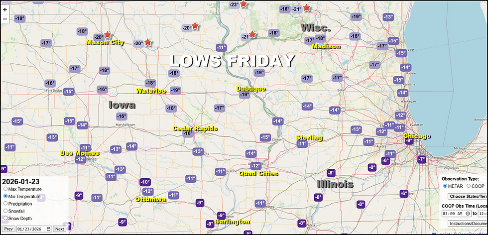
Once the big storm shifts east, it opens the door for a persistent northwest flow that promises an over-abundance of below normal temperatures the next 6–10 days. Fortunately, nothing quite as bad as what we experienced Friday morning, with Waukon in northeast Iowa tanking at 24 below zero. In my area, Dubuque was the cold spot at minus 19 with a wind chill of 42 below.
Locally, temperature anomalies the next 7 days are nothing to take lightly, with departures of 18–22 degrees below normal per day. We have numerous mornings where lows are likely to end up below zero. Cold weather advisories are possible on several days.

As far as snowfall goes, after Sunday, I don't see much until Wednesday, when a clipper in the northwest flow could deliver an inch or two of fluff. Something to keep an eye on in coming days. Look for an update on Saturday's snow potential around midday. Until then, I'm out. Roll weather and if you find value in the site, please consider a donation to my fundraiser...TS


Comments