


A FEISTY OLD WINTER STORM...
- Mar 14
- 4 min read
WINTER STORM WATCHES AND WARNINGS
A complex late winter storm will come at the Midwest in 2 phases Saturday night into Monday. We get out of the first phase in good shape, our neighbors to the north not so much, with heavy snow and ice in Minnesota and central and northern Wisconsin where warnings are in effect.
Locally, we get our crack Sunday night when the second phase of the storm comes to life bringing a snow threat along with powerful winds and crashing temperatures into the 20s. Whiteout condtions are possible, especially in the open country. In lieu of the potential, the NWS has issued winter storm watches that are in effect Sunday night and Monday from about I-80 (and the Quad Cities) north. With the storm track becoming clearer, it is likely some of these headlines will be upgraded to warnings and re-adjusted to fit the eventual track more precisely.

As you can see below, Winter Storm Warnings are already in effect in pink to our north. That's from the first phase of the storm which passes safely in that direction Saturday night and Sunday.

Thanks to the initial energy going north, warm air advection will drive temperatures above freezing Saturday into the range of 41 north to 57 south. Also, forcing for precipitation remains up north where snow develops Saturday night. Saturation does not commence in my area until early Sunday. Thus, temperatures remain nearly steady Saturday night with not much more than drizzle expected.
Sunday starts off mild with little inkling of what's to come. Showers and even a few thunderstorms are expected. A few of the storms in the south could be frisky with some gusty winds and hail potential. A level 2 out of 5 risk for severe storms has been issued SE of a line from Macomb to Galesburg on to Princeton.

Finally, in the afternoon the developing storm center in EC Iowa begins to deepen and pull in cold air. At 1:00 pm Sunday, you can see the front is on Dubuque headed for my counties in eastern Iowa. Ahead of it temperatures are ranging from 45 in Dubuque to 62 in Galesburg.

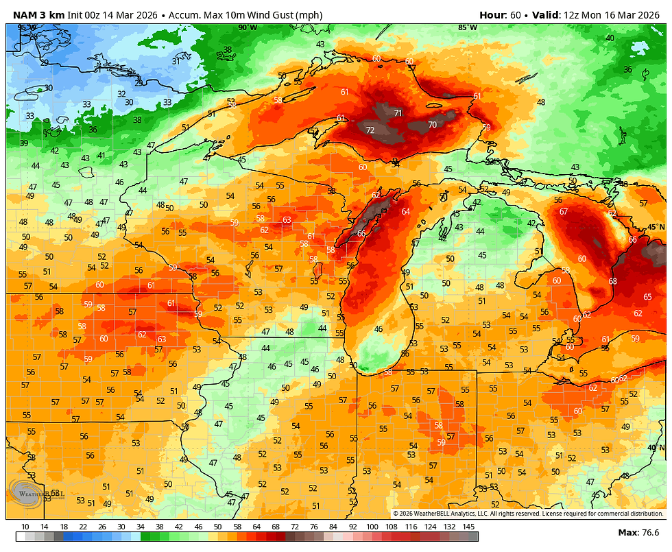
After the front passes towards evening, evaporative cooling kicks in and by evening temperatues are tanking and rain begins to transition to freezing rain, sleet, and eventually snow from west to east. Winds also increase significantly, eventually producing gusts of 50 to nearly 60 mph with temperatures in the mid to upper 20s by midnight.
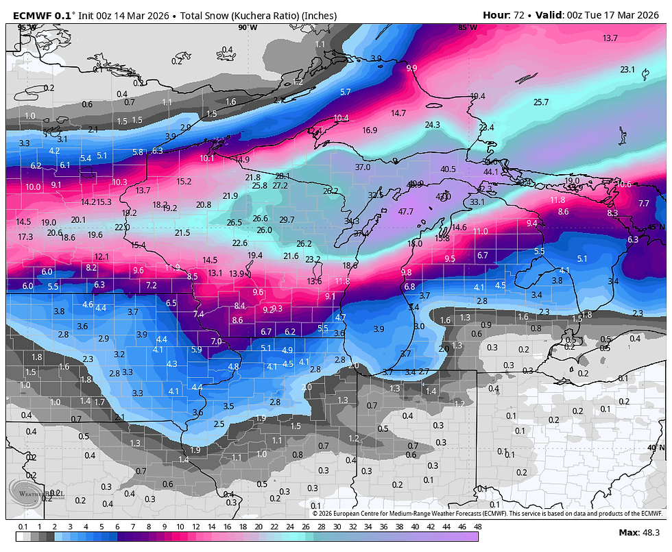
Now, the big question on everyone's mind, how much in the way of snow? And that is a difficult question with still some minor track deviations, uncertainty about where the trowel forms, as well as the timing of the transition from rain, to freezing rain, and eventually snow. Correctly assessing these variables will be tricky, along with the fact ground temperatures are warm. Honestly, it's almost impossible. That said, we can make an educated guess based on model blends. But to give you an idea of the spreads involved. here is the NWS forecast model. In Dubuque and Cedar Rapids for example shows, the NWS model shows a 1 to 6 inch range in its probabilistic amounts. In other words, confidence ain't great!

Turning to the raw model output from Friday night, here's what I'm seeing for solutions. These are not forecasts, just the guidance used to make them.
The GFS

The EURO
The 3k NAM

THE NBMv5, a blend of 30 models and ensembles

The 12k NAM
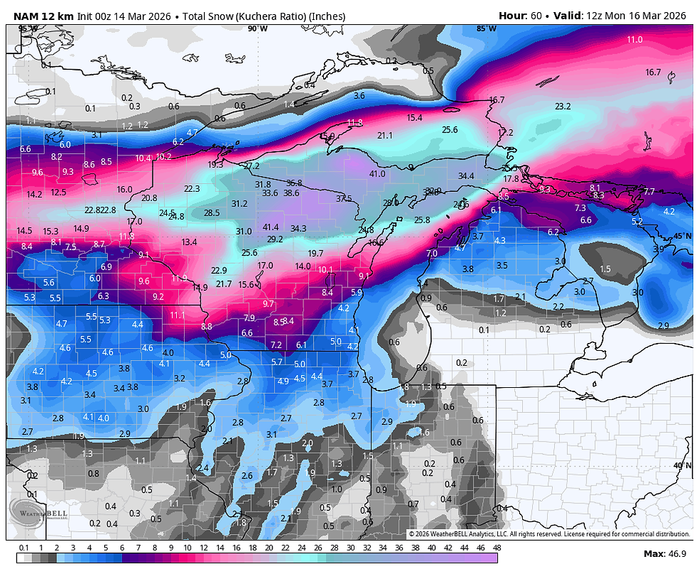
To varying degrees, all these models indicate snow that could be somewhat problematic. There is a definite trend for the heaviest amounts to be from roughly the Quad Cities northwest.
The snow in itself is not going to be crippling, especially with the warm ground initially. However, readings fall below freezing into the 20s pretty rapidly. That leads to a flash freeze situation where things could ice up fast. It's also possible that if freezing rain develops in the transition to snow, it could stick to elevated surfaces such as trees and power lines. Then the added element of strong winds (a given) ramps up concerns. If ice, heavy wet snow, or a combination of both accumulates, it is susceptible to wind. The 3k NAM and GFS both show gusts up to 60 mph in parts of eastern Iowa Sunday night. These are wind gusts indicated on the 3k NAM.
At this point, I don't think we can get much more refined until we have updated guidance later Saturday. Suffice it to say, we are trouble free much of Sunday before the wintry side of the storm is realized, unless it's a thunderstorm. 5-7 inches of sniow is possible NW of the Quad Cities, especially on a line from Cedar Rapids to Dubuque. Lesser amounts of 1-3 currently look probable SE of the Quad Cities. We have until Sunday evening, or roughly a day and a half to refine forecasts, advisories, warnings, and snow amounts. The track can still change altering amounts. Stay tuned and thanks for putting your trust in TSwails. Roll weather...TS

My sincere thank you to all of you who made contributions and have taken it upon yourself to support the site. TSwails is with you for another year. If you haven't contributed, and think the site has value, or you use it extensively, it is still possible to donate. Any contributions will go into a trust to be used to support the site going forward. Thanks again!


Comments