


A HOT START TO JUNE ACROSS THE MIDWEST

Hot and dry will be the theme to start the month of June with forecast models and analogs all supporting a prolonged stretch of quiet weather. Analogs, above, indicate a greater than 80% chance of above normal temperatures as we head into next weekend. The good news? The pattern may finally start to break down a bit giving way to some rain chances later in the period. More on that in a moment.
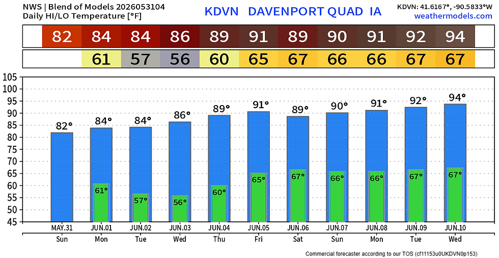
For the Quad Cities, temperatures will be steadily increasing over the next 10 days. Highs back near 90 are likely by late week into the weekend. Morning lows, worth noting, also start increasing into the mid-60s. Certainly feeling more like the depth of summer.

Before we get there, we are watching a little spotty rain chance on Sunday to end the month of May. This overall looks limited and you can count yourself lucky if you get a bit of rain for the yard.
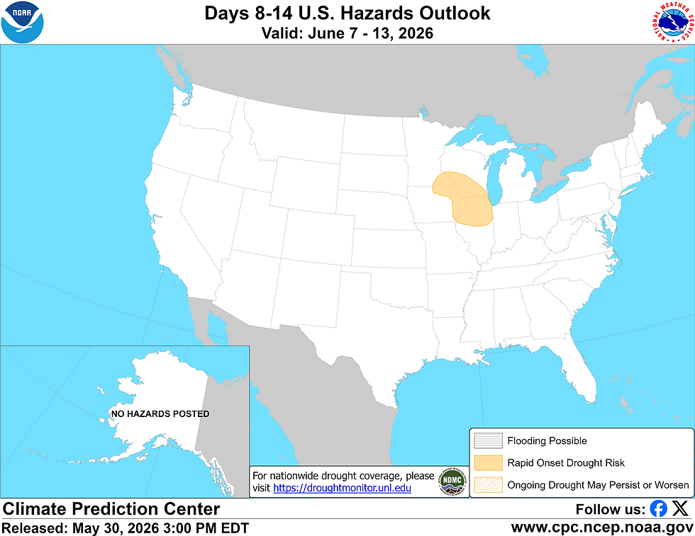
I mentioned last weekend the concern I had with rapid drought development with the prolonged stretch of dry weather and warming temperatures. The Climate Prediction Center actually has outlined a risk are for just that accross our area in Eastern Iowa and northern Illinois. There is not much in the short term to benefit us in terms of drought, however, longer term the pattern may finally start to break down and bring some more active weather,

The pattern has been stagnant due to an Omega Block in the atmosphere preventing weather from progressing west to east across the US. This is what will allow the heat to build and keep storms in check for now. These Omega Blocks can be quite stubborn and will take some forcing to get out of here to allow active weather to return.

The European Ensemble shows this pattern breaking down late this week into next weekend. The return to southwest flow will usher in more active weather and more moisture. Severe weather chances may increase with this pattern change going forward.
GFS - PRECIPITATION FORECAST

Euro - PRECIPITATION FORECAST

Long range forecast from the global models, the GFS and Euro, show some much more beneficial rainfall on the far end of the forecast range. While confidence in exact totals is low, the fact they are both showing some higher-end totals is a good sign. This looks to start around Thursday/Friday of this upcoming week with rain/storm chances continuing into early next week as well.
We will watch this closely in the days ahead. The main story for now will be the heat!
-Meteorologist Nick Stewart


Interesting outlook on the early June heat across the Midwest, especially with the Omega Block keeping conditions hot and dry while hints of a breakdown could finally bring better rain chances later on. The drought concern is definitely something worth watching as the pattern evolves. When taking a quick break from weather tracking, I’ve been playing Among Us — a fun way to switch off while still enjoying that same “figure out who’s real” kind of tension.