


A JANUARY THAW IS BUILDING
- Jan 4
- 3 min read

The coming days will feature a rather impressive stretch of warmth across the central US during a rather quiet and dry period of weather. A classic January thaw, but instead of a brief period of time this looks to be a rather prolonged period of mild temperatures, for January standards. Anomalies will be pushing 15-20° above normal for a large chunk of the US.
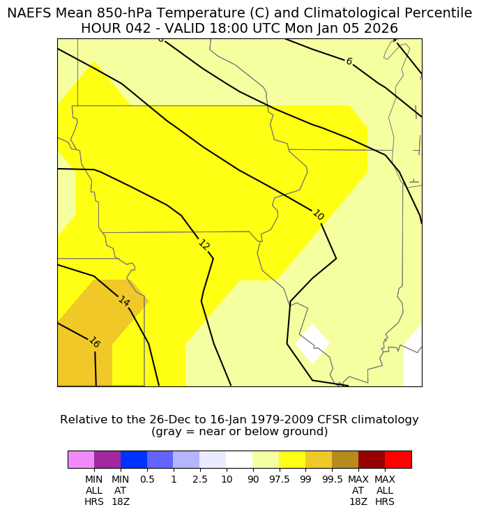
Air temperatures just above the surface early next week will be near records for this time of year. The 850mb temperatures will be in the 97th to 99th percentile - a strong signal for extremely anomalous air surging from the southwest. Bottom line is warming temperatures.

Blended forecast highs over the coming days will be surging in the Quad Cities region with highs in the 50s all but likely by midweek. In the extended period there is a trend towards some more seasonal highs, but even this looks somewhat on the warmer side of normal.

The temperature outlook from the Climate Prediction Center over the next 6-10 days is all in on the warmth with high probabilities with above normal temperatures through mid-January. So how common is the "January thaw?"
Looking at the Quad Cities there is some rather interesting data.

Ninety of the last 152 years have had a high temperature of at least 50 degrees - about 60 percent of six out of every 10 years. That's actually higher than I expected, but at the same time the idea of a "January thaw" does not seem that foreign to me.
In the past five years however, three of them had no 50-degree days (2021, 2022 and 2024). The years 2023 had three days and 2025 had four days of at least 50.

Looking at the various ENSO cycles, we are currently in La Nina. The probability of having a 50-degree day is the highest in El Nino, with La Nina in second. Neutral phases are the least likely, but even still a little more than half have had one. Recently 2021, 2022 and 2023 were La Nina in January, and two of those had 50s. 2024 was the lone El Nino January (strong El Nino at that) and had 50s, which makes sense given the historical data above.

One area to watch will be late this week in the Friday/Saturday time frame. Models are in line with a fairly strong storm system looming, although the spread in the models is fairly high in terms of storm track placement. Heavier precipitation is certainly possible with this system, although for the time being it's looking more like a rain event opposed to a snow event locally as the cold air just is not in place.

The 50 members of the European Ensemble are spread out across the region, but it's actually a tighter grouping than I would expect at this range. The tighter grouping is centered over Iowa which gives us the potential for precipitation depending on temperatures, but that placement is a cold rain locally if that's how it pans out.
EURO

GFS

There are some rather significant differences between the operational Euro and GFS regarding this system. The Euro is much more in line with the ensemble average closet to home and brings the rain threat locally with some more wintry precipitation the northwest. Trends will be important as it gets better sampled in the coming days! At least it's something to watch other than the prolonged warmth.
Have a wonderful weekend, friends!
-Meteorologist Nick Stewart


Comments