


A LOOK AT THE SPRING TORNADO SEASON
- Mar 21
- 4 min read

As we enter a bit of a stretch of quiet weather I thought now would be a good time to take a look at the spring severe weather outlook using analogs similar to this upcoming spring. I have been doing this the last several years and overall the verification has been pretty good. For our exercise we are looking nationally, trying to pin down areas and times of the spring that may see more active weather.

Last spring my analogs were indicating a somewhat active Central Mississippi River Valley as well as the Ohio River Valley with a more mundane season in Iowa and the Central Plains (bottom left). The top right image shows this verified quite well.

Years I will be using for this year include 2023, 2009, 2006, 2014, 2001 and 2018. Based on the parameters I look at these years in particular stand out as some of the closest to what I expect this spring to look like. Of note, 2023, 2009 and 2006 are the closest of those six.
Starting with the ENSO phase, we will be moving from La Nina to neutral conditions this spring, likely ultimately into El Nino by late spring and summer. These years match quite well with the forecast going forward.

As of March 9 the Climate Prediction Center has an El Nino watch in effect. Probabilities of reaching El Nino are pushing 40% by July and 60% in September. This is reflected quite well in all modeling and is a big driver for me picking analog years for this upcoming spring.

The Gulf is another big area to watch. Right now we are seeing near record warm sea surface temperatures, especially along the coast from Texas through Florida. The years 2018 and 2023 stand as the two-closest analogs to the current conditions. There's also a rather interesting "blob" of warm water in the central Gulf that is more than 3 degrees above the 30-year average.

The Northern Pacific is a major driver for weather pattern over the United States in Spring. This helps dictate at times the strength of those ridges that suppress weather, and big troughs that bring the severe weather threat. The top analogs for the current state of the Pacific are 2018, 2014 and 2023. There is a large pocket of well-above-normal sea surface temperatures across the North Pacific.

Looking at the tornadoes produced in our analog years we see some interesting data. Overall the season appears to be a below-normal year for tornadoes, however there are some certain periods to watch. Five of the six analogs are below the 15-year average of 2006-2020 tornadoes - most by a rather large amount.
Looking at the left image above, you can see there are some rather large discrepancies between the analog mean as well as the 15-year average. This really is pronounced in the month of May.

A reanalysis of May using our analog years at the 500mb level shows strongly positive anomalies in the western CONUS. This is an indication of strong ridging that would suppress severe weather and bring dry/warm conditions for the central US. For storm chasers, and farmers needing rain, this may not be the best look overall.

June on the other hand as a little bit of a better look. Lower anomalies over California could indicate stronger troughs that bring severe weather and storms across the central US. June may be a more active one than May in terms of overall severe weather and tornadoes.

Breaking out the months, April may be near-normal in terms of severe weather potential early with a quieter signal later in the month.
May similarly may start near normal for tornadoes before trending below to well-below normal in terms of tornadoes during what is normally one of the most active periods. Storm chasers like myself typically flock to the Plains in late May - this year I am changing my annual trip to June.
June as you can see below is the one month this upcoming spring that looks to run above normal. Four of the six analog years are well above the 15-year average. Mid to late June looks above to well-above normal for tornadoes. It's quite the look!
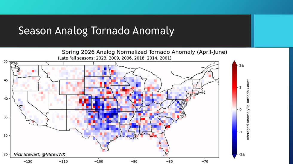
Geographically for Spring there is a lot of blue on this April-June chart. The central/southern Plains in particular look to be quite below normal in terms of total tornado count. There is, however, some signal showing up there in Iowa and Nebraska, as well as eastern Colorado, for above normal tornado totals. That has my interest.

Running the analogs for just April that signal in Iowa is quite pronounced, as well as downstream of the Mississippi River. April could be somewhat more active locally based on the analog years. Early April is actually looking active as well based on some of the longer-term modeling. Watching that closely.

As for May, it overall looks quite below normal for mush of the region. Some signal is there for well-below normal totals for Kansas, Oklahoma and Texas. The only real area to watch looks like eastern Colorado for more active tornado totals.

Going back to my chasecation plans, the above analog projection for June is why I changed it to June from May. There are a lot of hotter pixels here indicating an above-normal month for tornadoes across the central and Northern Plains. Eastern Iowa is also showing up quite well here in the analog years.
So to summarize the plots above - I like an active early April and month of June with a potentially quieter late April and late May. The caveat here is that all it takes is one event to completely flip the script on this outlook for your neighborhood. This is just a look at potential analogs.

Looking ahead, late March and early April there are some more active signals showing up in the ensembles. There is a rather large swath of above-normal precipitation totals showing up in the region March 30-April 6. Based on the discussion above, there could certainly be severe weather mixed in with this active period.
If you prefer a video discussion of all the topics covered above you can watch my YouTube video. I go over much of the same data, with a little extra sprinkled in as well. Here's to a safe spring season for all!
-Meteorologist Nick Stewart


Ce que je trouve intéressant dans certains contenus SEO, c’est leur capacité à rendre des notions complexes plus accessibles sans les dénaturer. Ici, j’ai eu cette impression dès les premières lignes, avec une progression logique dans les idées et une certaine fluidité dans la lecture. En consultant https://rhillane.com/agence-seo-maroc-referencement-naturel/, j’ai surtout retenu l’effort de structuration qui permet de comprendre les étapes sans avoir besoin de connaissances avancées. C’est assez rare pour être souligné, surtout dans un domaine où beaucoup de contenus restent superficiels.