


A METEOROLOGICAL 'BOMB' IN THE MIDWEST
- Dec 28, 2025
- 3 min read
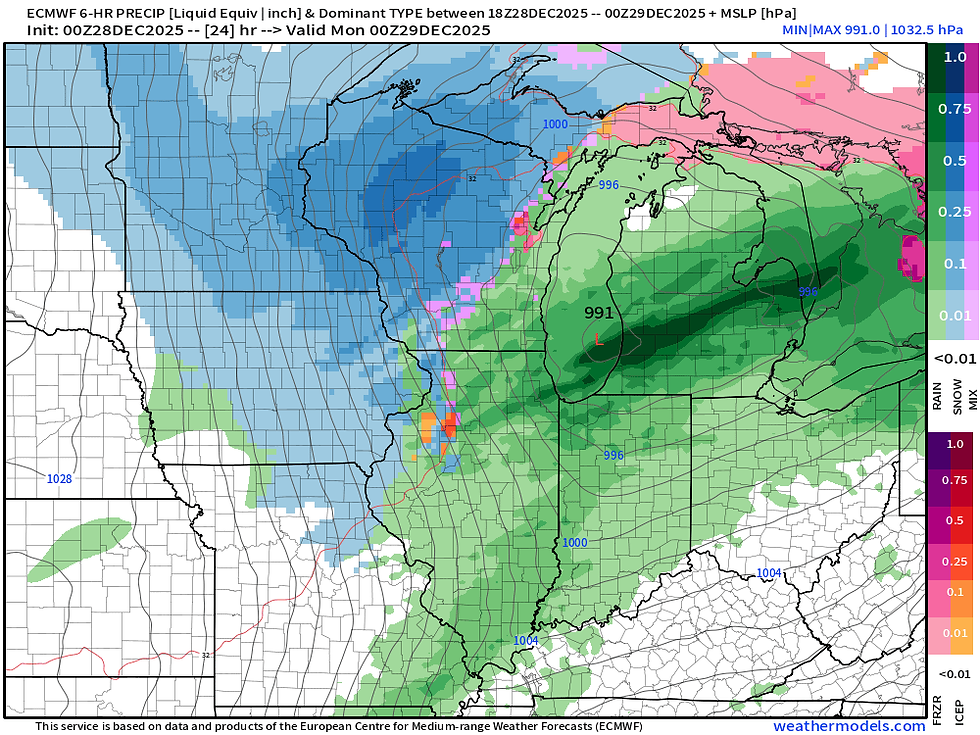
A powerful and dynamic weather system is taking shape across the Great Lakes Sunday which will feature rain, thunderstorms, powerful wind gusts, snow and blowing snow and crashing temperatures. An area of low pressure is projected to drop nearly 24mb in 24 hours, the definition of bombogenesis, or rapid deepening and strengthening of a weather system.

Showers and a few thunderstorms will continue to move through the region through Sunday morning an early afternoon prior to cold air flooding in. A few storms could be strong to severe in northern and central Illinois where the Storm Prediction Center has a Level 2 of 5 Risk, a Slight Risk, for strong storms. Notice by 11 a.m. (above) a transition to snow starting across central and northern Iowa and the cold air penetrates the back side of the system.

A slow transition to snow will continue with more widespread snow likely early Monday morning on the back side of the system. While snow accumulations will be minor, the combination of powerful wind gusts will lead to near blizzard conditions with dangerous blowing snow and limited visibility. Roadways will have the potential to flash freeze as temperatures quickly crash.

Winter Weather Advisories are in effect just north of the Quad Cities for counties roughly along and north of Highway 30. Farther north in Iowa Blizzard Warnings are in effect for the blowing snow concerns that will lead to extremely hazardous if not impossible travel conditions at times.

Overall now accumulation is not particularly high locally. Higher totals will be likely farther north, especially north of Highway 20. This will have the perfect combination of blowing/drifting snow that will lead to dangerous travel conditions. Still, along Highway 30 will have some minor accumulation of 1-2", but with the wind it will not take a lot of snow to cause major issues. The whiteout blizzard conditions with the wind is the concern.
THE HRRR

The HRRR is indicating some higher totals a little farther south than the official NWS forecast. Either way in a lot of cases you will not really be able to accurately measure the amount of snow due to the wind blowing and drifting it around. But if we do see these totals of 1-2" possible as far south as I-80, this would lead to significantly more travel issues along I-80 and in the Quad Cities region directly. This again would be most likely locally between about 4-8 a.m. of active snow, but longer with continued blowing.
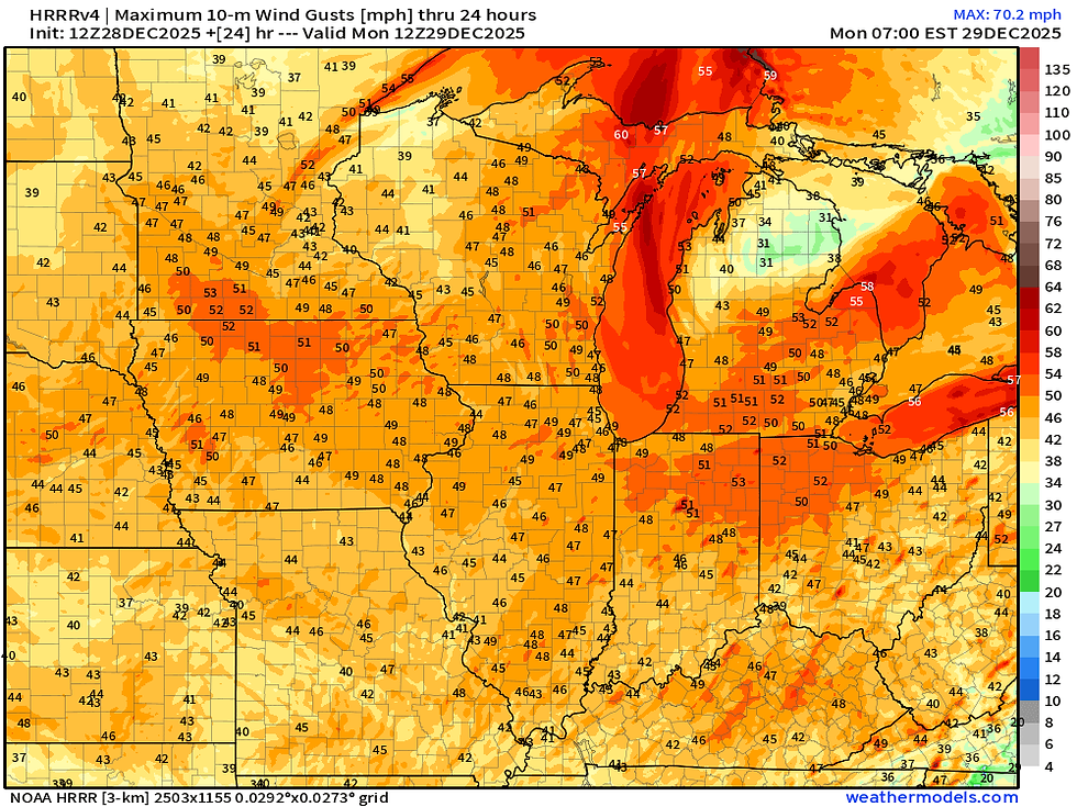
Above is the peak wind gusts anticipated over the next 24 hours across the region. Notice how widespread the 45-50mph gusts are. Wind Advisories are in place for nearly everyone in the region for these gusts.

The strongest period of wind gusts over 40mph will be later tonight through Monday morning with some gusts likely pushing 60mph at times. Powerful storm!

Temperatures will quickly fall through the late afternoon with temperatures in the teens by late night. These cold temperatures will persist through Monday with bitter wind chills given the strong wind gusts in place.

Monday morning wind chill values will be well-below-zero with the crashing temperatures and powerful wind gusts. Values of -5 to -15 are likely.

Bitter wind chills will persist into Tuesday. By Tuesday morning those values will likely be sub-zero once again across the region as winds are still increased with the system passing to the east. A cold stretch of weather is taking over and winter is BACK.

Briefly looking longer term, we will have more seasonal temperatures after this system with highs frequently in the upper 20s/low 30s and lows in the teens. Gone are the well-above-normal temperatures for now. Notice that cold outlier on Thursday, that comes behind a clipper system that could bring more accumulating snow to the area.

The Euro is indicating it quite well affecting the area later Wednesday into early Thursday morning. This could bring a quick hit of some fluffy snow reaching a few inches in a "best case" scenario for the snow lovers. The GFS is far less excited about it and bring little to now snow. We will keep watching it! Let's get through the system over the next 48 hours first.
-Meteorologist Nick Stewart


Comments