


A NEWFOUND NIP....
That storm that rolled through the Midwest Tuesday has today found a new home in Canada. That's allowed a cold front to sweep through the region, kicking up brisk westerly winds that have gradually been driving temperatures down. Wednesday evening readings were only in the 40s in many spots with wind chills approaching the upper 30s. Actual temperatures were 12 to 16 degrees colder than 24 hours earlier, mind you a noticeable change!

Despite the initial energy having passed well to the northeast, a secondary disturbance in the cyclonic flow will keep our weather unsettled again Thursday. Mostly cloudy breezy conditions can be expected with enough residual moisture to produce scattered light showers, especially late morning into late afternoon. These will be brief and light in nature, sometimes little more than drizzle. However, with temperatures struggling to get above 50 it will be a raw November day. Here's what the EURO indicates for rain totals from the spotty showers.

Once this disturbance passes, it tugs even cooler air into the region Friday generating considerable cloudiness and the coldest air of the year so far. Models are consistently showing highs in the low to mid 40s. That will make for a rare day of below normal fall temperatures. The HRRR has these readings at 1:00pm Friday.

It should come as no surprise that the region is yet to see a killing frost. In fact, many parts of the south have yet to reach freezing. That streak could come to an end Friday night with clearing skies and light winds allowing healthy radiational cooling. Lows of 28 to 33 are currently expected, assuming skies clear rapidly. There will be frost and most likely a freeze. Nothing that's out of line for November 7th.

After a cold start, the remainder of Saturday features a mix of sun and clouds with highs in the low 50s, pretty seasonal and about right for putting up some Christmas lights. Believe it or not, it's not that far away. The Christmas commercials have already burst onto the scene.
ANOTHER SURGE OF INDIAN SUMMER.....
Just when it feels like winter is making some small gains, El Nino brings another round of pleasant weather back to the country starting early next week. Here's the EURO's projected average temperature departures for the next 7 days...week 1.

Here's it's average temperature departures for week 2. November 12-18th. Blow torch!

Average precipitation departures on the EURO the next 7 days. Week 1.

The average precipitation departures for week 2. November 12th-18th.

These are the 8-14 day temperature outlooks from the Climate Prediction Center November 12th-18th.

The associated 8-14 day precipitation outlooks from CPC for the same period.

The screaming message for the next 2 weeks is that starting Sunday we enter another period of mild and what looks to be relatively dry weather. The EURO shows this for temperature trends November 5th through the 19th.

What we have here is a situation where a strong El Nino is has split the jet into two distinct cores. The sub-tropical jet, which delivered our recent storm is favored to remain largely to our south. The Polar jet, with its connection to cold air is racing across Canada, limiting cold air intrusions resulting in above normal temperatures. That should keep our weather very pleasant by November standards through roughly November 20th. Here's the mean 7 day jet the next week with mild Pacific air dominating the country.
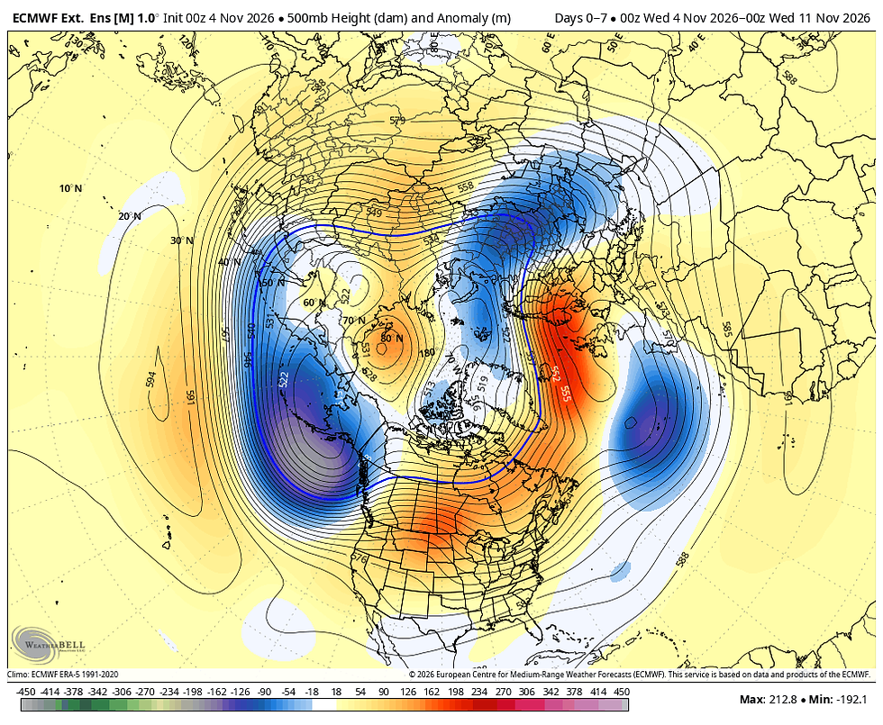
By the period December 10th through the 17th, there is a signficant change shown with the powerful vortex in Alaska weakening and becoming displaced further south. Also, blocking in Canada is forcing an active storm track to materialize over the SC and EC United States. That configuration allows colder air to make inroads into the central and eastern U.S. It doesn't look extreme, but cold enough to allow snow to fall north of systems cutting east in the southern stream storm track.

Sure enough, the EURO ensemble mean of the weeklies finally shows snow entering the pattern late in November or early December. Here is its 46 day snowfall forecast which is pretty impressive nationally between now and December 19th. Most of what is shown locally comes November 29th and beyond, roughly 3 weeks away.

So, while it won't snow anytime soon, long range guidance does see it happening as we approach December. Of course, there is no guarantee it occurs, but the trend has been consistent in long range guidance for about a week. That's enough to give a forecaster hope! Roll weather.....TS


Comments