

SHORT TERM PAYBACK...
For the most part, our weather pattern is unfolding about the way it was expected to at this point in our storms evolution. Low clouds and rain were prevalent ahead ot the trough Tuesday with the heavier rains falling just NW of the Quad Cities in my Iowa counties. Doppler radar estimates have some 2-3 inch totals in a narrow band from Iowa City to Cedar Rapids. Additionally a few 2 inch amounts are also shown from Tipton southwest to West Liberty and Ainsworth. Here are the Doppler estimates as of late evening.

On the GOES 19 satellite imagery you can clearly see low pressure inching into Minnesota with a plume of deep moisture surging northward into the circulation.

With my local area in the warm sector of the storm Tuesday, highs of 66 to 70 were achieved thanks to brisk south winds. Even more impressive were the dew points which rose to levels as high as 65 degrees! That's a real achievement for November 3rd.
Showers and even scattered thunderstorms have rapidly diminished Tuesday night with the arrival of a cold front that clears the region by daybreak Wednesday. That front effectively cuts off the systems moisture and its rain producing ability Wednesday due to dry slotting. On top of that, brisk W/NW winds will begin to tug cooler air into the region with cold air advection slowly gaining a foothold. As a result, only a few stray light showers are possible in the north Wednesday despite considerable cloudiness in most of the area. Temperatures will move little remaining in the low to mid 50s. Similar temperatures are expected Thursday but shower chances increase a bit in the north due to a trowel rotating across that part of my area. Amounts will be minimal but it reinforces cloud cover resulting in a chilly day. It's a bit of payback for the warmth we've enjoyed the past few weeks.
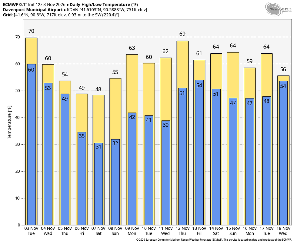
Speaking of chilly air and paybacks, Thursday's disturbance taps into even cooler air keeping highs Friday and Saturday in the mid to upper 40s, the coolest of the season so far. Yet, just when it looks like things are trending towards a more normal brand of November weather, mother nature says not so fast my friends. The 500mb flow reverts to the familiar pattern of upper Midwest ridging by next week instigating what will likely be another period of dry unseasonably mild conditions. That deep low in the Gulf of Alaska, very typical of a strong El Nino flushes what minimal cool air exists and the country warms up again.

These are the 7 day average temperature departures for the week 2 period (November 11th to the 18th). My local area is running 15-17 degrees above normal per day.

Here's what the EURO is suggesting for temperature trend the next 2 weeks. That does not look at all like mid-November!
Barring some radical changes, I sure don't see any signs of wintry weather before November 20th at the earliest with the El Nino pounding away. Beyond that, a stratospheric warming event and MJO trends will be things to watch that could swing the pendulum a different direction by Thanksgiving. The EURO certainly thinks so with its weeklies showing this for snow totals by December 18th, all of it coming after December 1st. I certainly can't guarantee such an outcome but it is heartening if you are a snow buff.

Other than that, there's not much to say other than we are in for some dreary, blustery, and cooler conditions the next 2-3 days. That said, there's no reason for dispair as I see rapid improvement again by early nest week. Roll weather...TS.


Comments