

ELECTION DAY BLUES...
One of the biggest mid-term elections in U.S. history promises to be a wet one around the central Midwest. Decision day, while soggy at times will at least be one of the warmest on record with highs (despite the dreary conditions) destined to hit 65 to 70 degrees. Here's a meteogram of what conditions are expected to be like throughout the day and evening (specific to the Quad Cities) if you are headed to the polls. Notice the low is 62 and the high is 69. Rain chances are at 90 percent with nearly a 30 percent shot at a thunderstorm. The dew point soars to 64 which is at 99 percent of early November climatology....very moist!

Now that the storm and its rain has arrived, it's complicated make-up will keep the chance of at least scattered showers going into Friday night. That said, the lions share of the rain falls Tuesday and Tuesday night. After that, it's more showery, light, and occasional in nature. The ensemble of the EURO indicates this for rainfall potential through Friday. Rainfall of an inch is fairly common with a few spots picking up 1.50 inches in banding.

The National Blend of Models (NBM) has this for amounts. You can see there is a tendency on both models for the heaviest totals to fall west of the Mississippi into NW Illinois.

The mild springlike air will hold locally through Tuesday night. However, Wednesday morning with a cold front advancing across the region, winds will switch to the NW and temperatues will begin to slowly decline. By afternoon readings will slip into the 50s and likely stay in the 50-55 degree range the remainder of the week and probably into the weekend as well. That gets us back into a far more traditional temperature pattern for early November.
That will be a change from the incredible readings we put up in October. The daily October temperature departure in Cedar Rapids was 8.9 degrees above normal (per day) making it the 5th warmest of record. Burlington, Dubuque, and Moline all had their 8th warmest. It was also a dry month with most locations at least 1/2 inch below normal. In Dubuque just 1.23 inches of rain fell which was 1.70 inches below the norm.

Once our current system spins off to the northeast we revert to a pattern that's similar to what we saw the the last 2 weeks of October. That implies a return to relatively dry, mild conditions. Here's what the EURO ensembles show for week 2 temperatures November 7-14th. A return to readings 7-8 degrees above normal.

Add that to what looks to be a rainfree upper air pattern and we are riding high in the saddle again. Week 2 precipitation totals show no measurable rain November 7-14th.

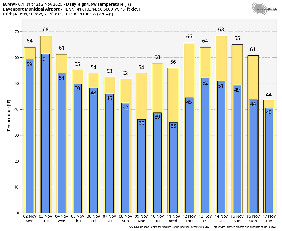
Here's what temperature trends look like the next 2 weeks on the EURO and GFS. There's little sign of winter as the El Nino continues to rage sending mild Pacific air back into the Midwest.
The EURO
The GFS

That's where we stand heading into election day 2026. If you care about your leaders and the direction of your country, by all means exercise your constitutional right and vote. Roll weather...TS.


Comments