


APRIL SHOWERS (AND STORMS)...
- Apr 19, 2023
- 5 min read
After a frosty start, Tuesday turned out to be a bright, pleasantly cool day. However, early on temperatures were cold enough to nip some of the flowering shrubs and trees, especially in my northern counties. The low in Waterloo hit 25 and here in Dubuque we went down to 26. That's enough of that!
The quiet weather was a nice change from the wind, rain, and snow of the weekend. Unfortunately the break will be short as the pattern gets revved up again with another storm that brings periods of showers and storms back to much of the Midwest through Thursday.
You can already see clouds gathering Tuesday night out west that will bring showers and storms to some of us by daybreak Wednesday.

As evidenced by the explosive development of clouds, moisture is already being injected into the next trough digging into the Rockies. By Thursday morning water vapor greater than 1.25" has advected as far north as HWY 20. That will be the juice necessary for a widespread Midwest rain event.

At 500mb, you can see the energy that drives the storm moving out of the Pacific NW developing another large cold core upper air low this weekend.

That means we get our rains Wednesday into Thursday followed by another shot of very chilly mid-April air Friday. Once that arrives to start the weekend, a cool active weather pattern looks to be in place much of the next 2 weeks. CPC shows it in their 6-10 day outlook April 24-28th.

It's still alive and well in the 8-14 day outlook April 26th-May 2nd.

The GFS is certainly not a sight for warm air lovers showing these10 day temperature departures April 24th through May 4th. That's just ugly.

And to prove it's ugly, here's the 16 day meteogram for Cedar Rapids. From April 21-May 4th it never has a high of more than 58 degrees. 8 of those days highs are in the 40s! 8 lows are in the 30s, 3 of them below freezing. Just when you thought spring had sprung you get this. That's disappointing!

ONE HOT DEAL... 3 NIGHTS FOR THE PRICE OF 2 MEMORIAL WEEKEND IN GALENA

THE LITTLE WHITE CHURCH AWAITS YOU
Get the gang together. Kick off summer with a free night at the church, one of the most unique stays in the Midwest. Call Carolyn at 563-676-3320 or email carolynswettstone@yahoo.com CLICK HERE
CHILLY BUT IS IT WET?
Often times when you see a pattern as cold as what's depicted, precipitation is often below normal with NW flow cutting off Gulf moisture. I could see that happening but the GFS is not of that mind set showing well above normal precipitation the next 2 weeks. It's heavily front loaded in my opinion and I'm not so sure totals will be this robust beyond the next 7 days, especially over so much real estate.

Should it verify, this run of the GFS is also very ominous for the main stem Mississippi which is rising rapidly and forecast to reach major stages throughout my region from Dubuque to Burlington and most likely well past Keokuk in later projections. Below you can see some of the anticipated crests and their timing. Additional precipitation (more or less) could alter the levels and timing.

One of the places that is vulnerable to flooding without a permanent flood wall is Davenport. I see now at lock and dam 12 in Rock Island a crest of 20.5' is anticipated. That's just 2.2" below the record set on May 2nd of 2019. After what happened that year ( a breach that flooded the riverfront) I'm sure the city is fortifying heavily.
That brings us to this next event which seems to be focusing its heaviest rain and highest impact weather just to the W/NW of my area. Scattered showers and storms will impact the area north of I-80 before fizzling by afternoon along a slow moving warm front. The rest of the region looks rather capped and rain free. The warm front barely reaches HWY 20 keeping my northern counties, especially those near HWY 20 struggling to reach 60. However, from I-80 south highs could explode into the range of 75-80. With dew points in the upper 50s to near 60. It will be a real spring like day in this part of my area. Here's what the EURO indicates for temperatures around 4:00pm.

With the warmth and moisture pooling along a wave of low pressure in SW Iowa and the warm front tied to it in central Iowa, that area is most likely to see strong storms flare up Wednesday evening. Instability is not lacking near and south of the warm front. Here's CAPE.

Once the cap breaks strong to severe storms should rapidly develop in SE Nebraska and western Iowa which then translate east. Here there will be a supercell/tornado threat with the initial cells which should grow linear fairly quickly. Then the concern is large hail and gusty winds. I think the most likely time and area for severe storms is in the early to late evening over western and central Iowa and SPC has them pegged in its risk assessment Wednesday. Level 2 out of 5 risk.

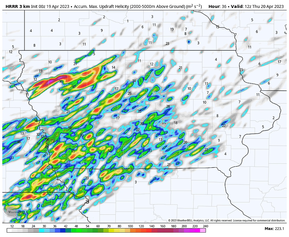
The HRRR does show numerous helicity tracks in western and central Iowa indicating some robust rotating supercells. Things could get rocking for a few hours in this part of Iowa.
Some of these storms could bleed into the southern half of my area well after dark but by then gusty winds and heavy downpours would be the biggest concern. North of the warm front and surface wave, some elevated storms may traverse my northern counties with some threat of a couple hailers from the stronger updrafts.
Scattered showers and storms look likely in my area Thursday morning before diminishing around mid-day. Around that time the cold front approaches my western counties becoming the focal point for additional thunderstorm development later in the afternoon. These storm are likely to fire near and east of the Mississippi late in the day but should quickly exit the region early evening as the front sweeps into central Illinois. This part of the forecast is low confidence as mesoscale details from morning convection and the speed of the front will dictate if any storms can fire and how strong they might be. The area from SE Iowa into WC Illinois has the best chances of seeing anything severe.
Getting back to the rain, here's what models are suggesting for rain totals through Thursday night.
The EURO

The GFS

The Weather Prediction Center outlook.

The 3K NAM

The Hi RES Canadian GEM HRDPS

Once the cold front clears Thursday evening very cold air for April 21st begins to dig into the Midwest for Saturday and Sunday. Saturday just looks miserable with 850 temps of -8 to -10C...that's about 5,000 feet up. That will produce big lapse rates and plenty of instability for clouds and wind. I would bet there will be some snow showers around too, especially in the north. Temperatures may be hard pressed to get out of the upper 30s to low 40s. Readings look to be 20-25 degrees below normal over much of Iowa. Ugh...

That's enough good news for one day, until next time roll weather....TS
A MESSAGE: Voluntary donations from people like you support the content, infrastructure, and operational cost of this site. Your contribution however small, makes a big difference. Please consider a donation, and thanks to the 416 of you who have answered the call. It is greatly appreciated. Just click the banner to make a voluntary donation. TS


Comments