


BIG RAINS FOR SOME - A CLOSE CALL
- Mar 1
- 3 min read
OPTIMISM FOR THE FUTURE

Friends, we are so close. I'm on the cusp of reaching the funding I need to get the site through another year. I'm at 96% of the necessary goal. Nothing would make me happier or more reIieved to get it behind me. I just need a little bump to get over the hump. If you use the site daily, find it informative, or make financial decisions based on it, please consider a donation. Any bit helps to keep the site going in its no-pay format. Nick and I will work hard to bring you the reliable value you have come to expect the last 13 years. The future is up to you. Thank you for your help!

All signs continue to point to a very active pattern taking shape across the central US. The latest Weather Prediction Center forecast has a large area of 3-4" of rain over the next seven days. This pattern is so close, yet potentially just far enough, from meaningful rains for the area. The upper air pattern is warm and loaded with moisture and we can be hopeful we at least get a taste of the action.

Moisture levels in the atmosphere Tuesday through most of the week will be well into the 90th percentile, so well above normal for this time of year, although likely not quite record breaking. This will be the moisture supply to allow some very heavy rainfall across the region, including a flash flood threat.
TUESDAY

WEDNESDAY

THURSDAY

Ahead of the storm system we already have multiple days of flash flooding risk across the central Mississippi River Valley. Too much of a good thing in too short of time, looks likely. Locally for the Quad Cities region into eastern Iowa, this looks like some rain opposed to a flash flooding threat.
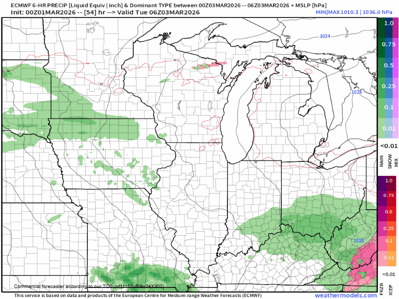
Tuesday and Wednesday appears to be a miss for our area with the heaviest rain in Missouri and central Illinois. This is supported well by the Euro (above), but some other guidance is farther north with the rain threat on Wednesday.

The GFS, above, shows the Wednesday system farther north brining more rain to our area. This would be ideal. Confidence in this solution is rather split as the Euro and its ensembles are south, while the GFS and its ensemble members are also farther north. There's clearly two camps at this point.
GEFS

EPS

The sharp cutoff on the European Ensemble in particular across Iowa and northern Illinois is impressive while the GFS clearly extends more precipitation farther north Wednesday.
For now we will keep the rain chances on Wednesday until we get a clearer picture as to how this week will develop. Lots of questions remain.
THURSDAY

The active week continues on Thursday with yet another round of widespread rain likely. This once again is favoring areas to the east and southeast but, again, is too close to call. We will watch for the rain threat to continue through much of the week with a very favorable upper air pattern remaining locked in place.

Looking long term the southwest flow allowing the continued storm threat looks to linger through the middle part of next week. Around Wednesday to Thursday next week we may finally see the upper air pattern break down and bring a break from the active, wet pattern.

Temperatures look to steadily warm up through this period as well. In fact 60s are quite likely by the upcoming weekend - very springlike as we head into March! Given the warmth and active pattern, what about any severe weather potential?

Analogs are pretty consistent with keeping the severe weather prospects to the south across the southern Mississippi River Valley. This makes a lot of sense given the likely positioning of the jet stream this upcoming week. I do believe we should be mostly clear of severe hazards but this can always change.

Machine learning forecasts going into the upcoming weekend likewise keep the severe threat down south. Ideally we get just the rain without the severe threat. Farther south I do believe there could be some severe weather potential, especially Wednesday onward. The 15% risk shows up Tuesday, Wednesday and Friday. across the southern US.
The calendar reads March, and the pattern is fitting for it! Have a great Sunday.
-Meteorologist Nick Stewart
On a closing note, I am just 600 dollars short of reaching my fund raising goal to keep the site going past this year. I'm making one last push to reach the top of the mountain. Anybody willing to donate 300 dollars will get two of my autographed books, my bobblehead, and a Terry Swails rain guage. Please, if you can help in any way, it would be greatly appreciated. Roll weather...TS


Comments