


BLIZZARD CONDITIONS TONIGHT
- Mar 15
- 3 min read
A BLIZZARD WARNING IS IN EFFECT
WHEN: SUNDAY EVENING UNTIL MIDDAY MONDAY
WHERE: ALL OF THE AREA
WHAT: 5-10" OF SNOW, 60 MPH WIND, WHITEOUTS

SUMMARY:
A deepening storm system is developing over SE Iowa that will track NE into southern Lake Michigan early Monday. Cold air surging into the circulation is causing thickness levels to collapse, allowing rain to turn to snow in much of Iowa. In some areas a brief mix of freezing rain precedes the transition. That trend spreads across the Mississippi later this afternoon and evening. The intense dynamic cooling vents and deepens the storm system tonight. The central pressure in the cyclone falls to 28.85 inches by Monday morning.
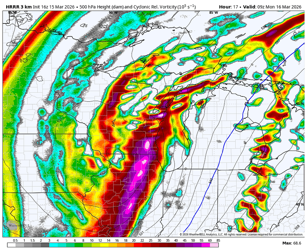
A deformation band yet to form, develops directly over the region tonight as the upper air energy enters the storm allowing it to get better organized and intensify. A 24mb pressure gradient across Iowa ramps winds up towards evening with the HRRR indicating gusts of 55-60 impacting the region by midnight.

A 500mb closed circulation with a negative tilt appears after midnight between Dubuque and Rockford, further proof that the storm is steadily deepening with pressure lowering.
A significant expansion of precipitation and its intensity occurs late evening and especially overnight, when snow really gets underway with vigor. Temperatures will be colder by then, allowing higher snow ratios. This coincides with the heaviest winds and significant blowing and drifting of falling snow is likely. Most of the snow accumulations locally do not occur until mid to late eveing and beyond when the system explosively deepens. Travel is expected to be severely restricted in open areas with blizzard or whiteout conditions expected for a lengthy period of time. Travel after the evening hours is highly discouraged overnight. Heed the warnings.
If I'm reading the trends correctly, I think snow totals have the potential to be higher than what has been previously indicated. The hi-resolution HRRR (which is run hourly) is aggressively seeing the deepening trend tightening the trowel and intensify deformation band snow. It's also the furthest west. By 5:00am. it indicates snow totals like this, with snow still ongoing.

The simulated radar shows the snow band wrapping around the storm center near Chicago at 1:00am.

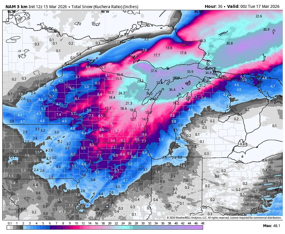
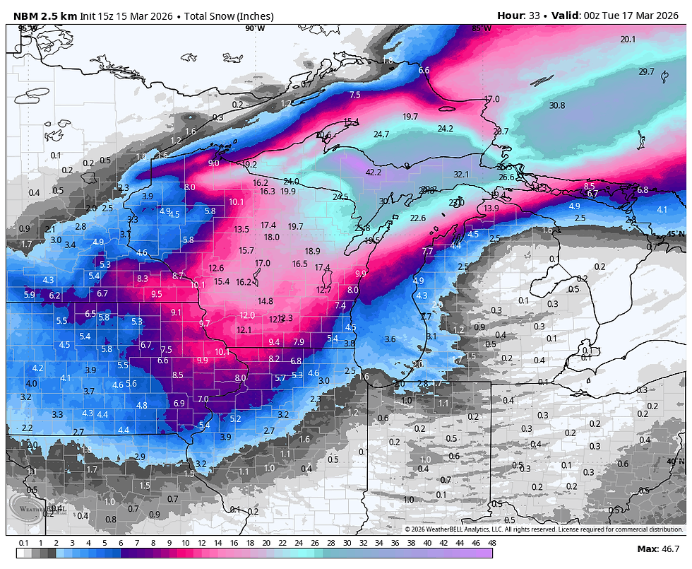
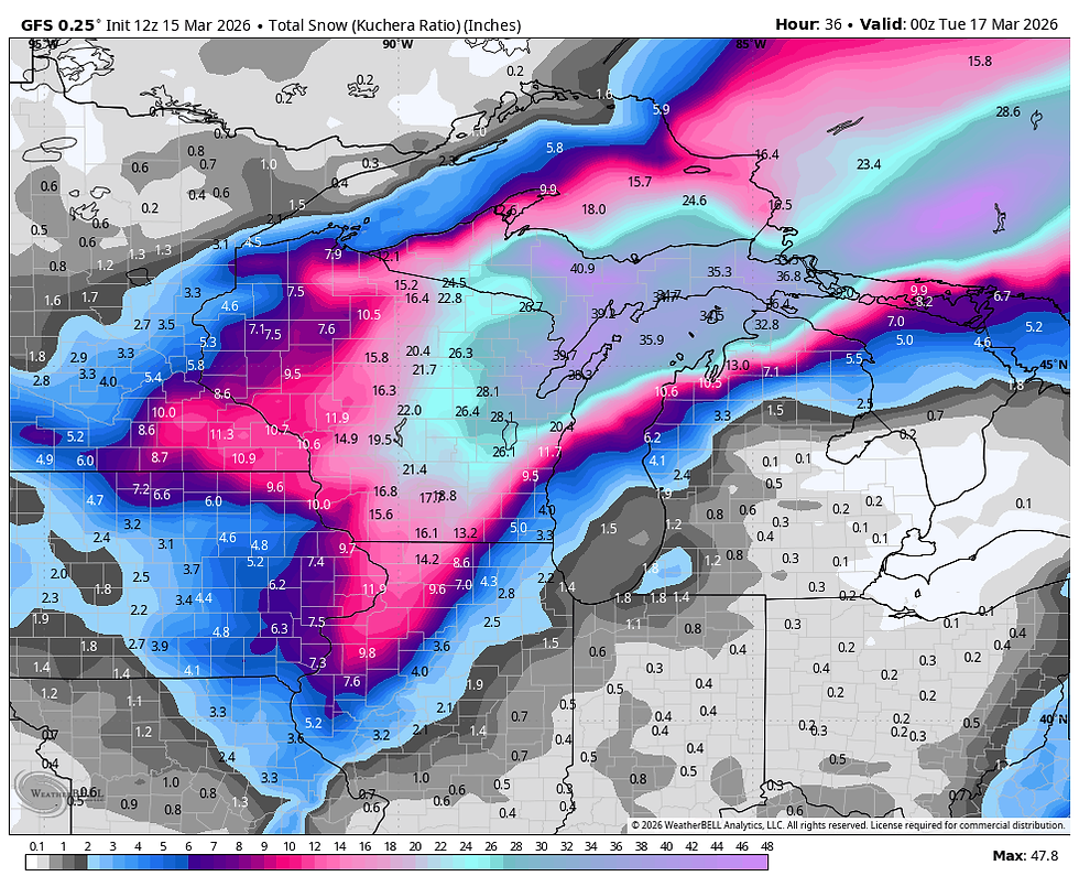
Here's some additional snowfall guidance. This is strictly raw model guidance, not actual forecasts. This is what we use to detect trends and make forecasts.
The 3k NAM
The 12K NAM

The RRFS

The NBMv5

The National Blend of Models
The GFS
The EURO

The general consensus is that the NW half of the area (roughly the Quad Cities NW) is in line for 6-8" totals (maybe a few 9" amounts). Further SE, closer to the track of the storm, amounts of 4-6" are on the table, lightest in the far southeast. I'm basing this heavily on the HRRR which through 6:00am Monday shows this.

Again, I don't expect the main thrust of the storm to get underway until mid to late evening when things should rapidly go downhill. Updated snow models for you this afternoon or evening as needed. Roll weather...TS

My sincere thank you to all of you who made contributions and have taken it upon yourself to support the site. TSwails is with you for another year. If you haven't contributed, and think the site has value, or you use it extensively, it is still possible to donate. Any contributions will go into a trust to be used to support the site going forward. Thanks again!


Comments