


BLIZZARD WARNING ISSUED
- Mar 14
- 3 min read
A BLIZZARD WARNING HAS BEEN ISSUED SUNDAY NIGHT MONDAY
TIMING 4:00pm. Sunday to 1:00pm. Monday
WHAT: Blizzard conditions and 4-8" of snow, Winds up to 60 mph
WHERE: Eastern Iowa and NW Illinois

A POWERFUL WINTER STORM TAKING SHAPE:
A rather complex winter storm is taking aim at the Midwest that will produce significant impacts over Minnesota, Wisconsin, Iowa, and NW Illinois. The system has minimal effects locally until it enters the region early Sunday. At that time, temperatures will be warm enough for showers and thunderstorms to develop and spread east. Come mid-afternoon Sunday, the surface low is depcited to be near Clinton, Iowa with a central pressure of 984mb. A narrow but active midday band of thunderstorms is possible along the cold front extending south of the low into WC Illinois. Further NW, cold air is being drawn into the storm changing rain to snow in my NW counties. A brief period of freezing rain or sleet may accompany the transition as it works its way SE Sunday evening.

Things start going downhill around 4:00pm. Sunday in the NW when the temperarture in Dubuque is shown at 35 while not far away the Quad Cities is hovering near 61.

The cold air to the NW marches steadily east as the low advances into NE Illinois. By 8:00pm. readings west of the Mississippi are in the 20s with low 30s elsewhere.
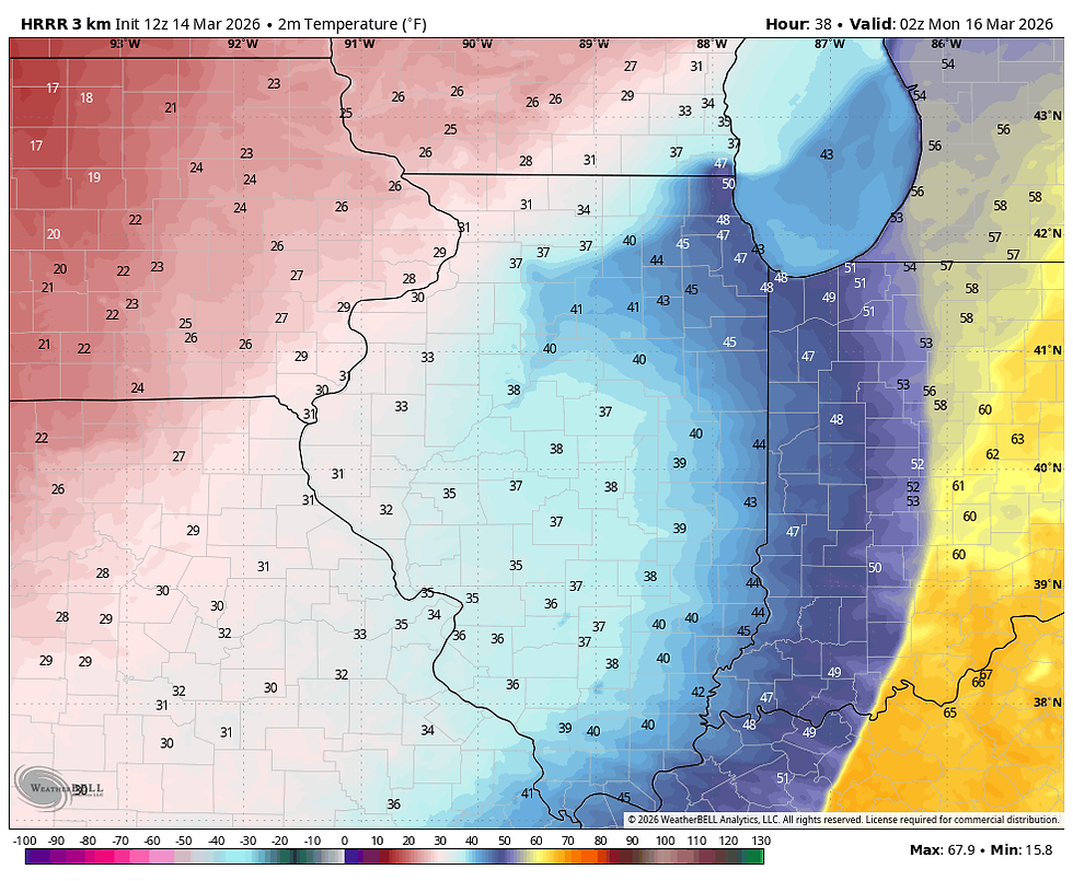
This is the point when things should go downhill fast as snow develops in the trowel west of the surface low. Aside from that, pressures across Iowa show a 24mb gradient implying explosive winds with gusts of 55, perhaps even 60 mph possible. With the flash freeze, significant blowing snow and falling snow will severely restrict visibility in the open country. In lieu of this, the NWS has issued the Blizzard Warning Sunday night into mid-day Monday. The HRRR shows a gust of 66 mph in Dubuque around midnight.

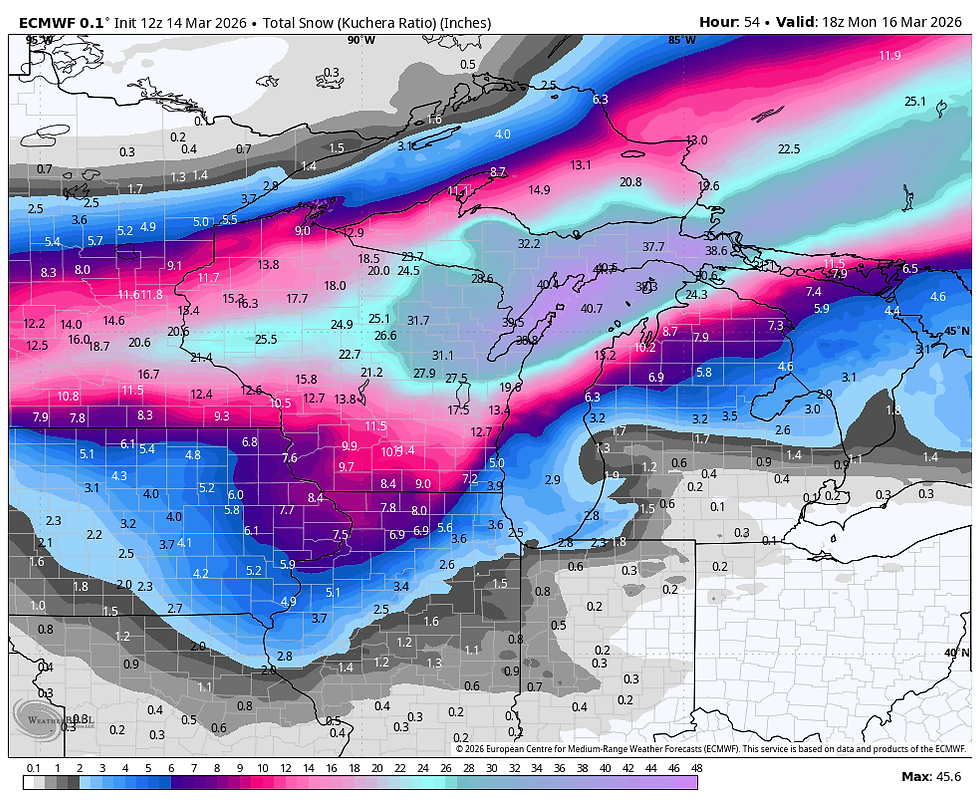
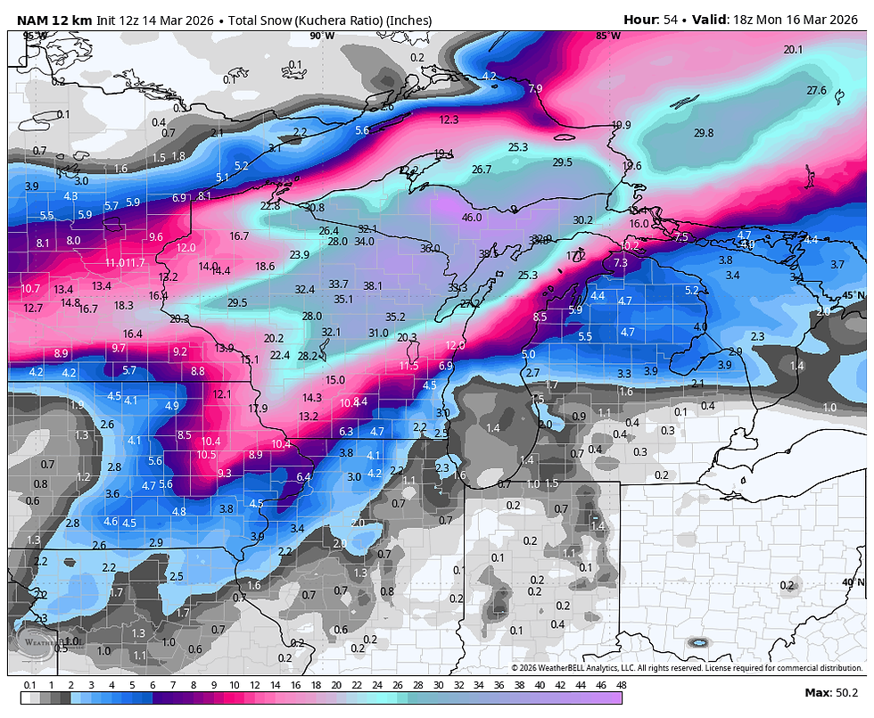
As far as snow is concerned, amounts will not be exceptional but a 3-7 inch fall is expected in the region where the blizzard warning is in effect. Some local spots in the far NW could see up to 8. The higher accumulations still appear to be close to a line that runs from Cedar Rapids to Dubuque. Here's the latest raw model ouput concerning snowfall potential. These are not forecasts, just guidance that is used to develop and produce a forecast.
The EURO
The GFS

The 3k NAM

The 12K NAM
The National Model Blend

The NWS model showing probabilistic ranges is still indicating quite a variance, indicating some uncertanty. It at least give you an idea of where it thinks the heavist amounts fall. I think it should be positioned further NW for what it's worth.

The heavier snow should taper off later Sunday night but light snow or snow showers are likely in the north though the morning. Additional accumulations would be under an inch but with strong winds continuing, visibility restrictions will remain in the open country.
We still have 24 hours before the show begins. We'll need to moitor the strom for any shift in track that could alter the outcome. Roll weather...TS

My sincere thank you to all of you who made contributions and have taken it upon yourself to support the site. TSwails is with you for another year. If you haven't contributed, and think the site has value, or you use it extensively, it is still possible to donate. Any contributions will go into a trust to be used to support the site going forward. Thanks again!


Did the storm track adjust slightly north from the earlier runs?