


BLOCKBUSTER WINTER STORM UPON US
- Mar 14
- 3 min read

Ready or not, here it comes. A major impact winter storm starts to move into the region Sunday with impacts likely continuing through Monday. The combination of heavy snow, blizzard conditions and tumbling temperatures with powerful wind gusts will lead to a very dangerous situation developing across the region.
However, I want to start with the pre-blizzard activities: severe weather.
As is common with March winter storms the warm side of the system will likely contain severe weather potential. In this case, the same areas that may see severe thunderstorm warnings early Sunday are also in a blizzard warning across Iowa.

A Level 1 of 5 Risk, a Marginal Risk, is in place across Iowa. This will be a hail threat overnight with any thunderstorms that develop. Yes, severe weather in a blizzard warnings. It's March baby! Overall hail should not be a major factor but don't be surprised for a storm to wake you up!
OK, onto the serious business.

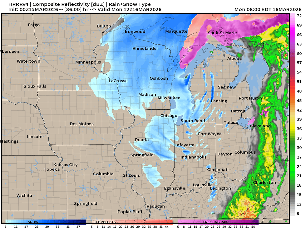
By daybreak Sunday heavy snow will be ongoing to the north including Green Bay to the Twin Cities and over to Sioux Falls. Meanwhile in Iowa you can see the isolated thunderstorms in the "warm" sector. If you have anywhere to be in our area Sunday you want to get there before noon. The bigger impacts will move in later Monday afternoon and when it hits, it will be a sudden impact.

The HRRR indicates the snow moving into eastern Iowa, southwest Wisconsin and northwest Illinois somewhere around 6-9 p.m. Again, when the snow hits it will immediately get into dangerous territory with whiteout conditions possible. Traveling, especially in rural open areas, will be extremely dangerous if not impossible.

Wind gusts around this time on the HRRR are in excess of 50mph, with some peaks near 70mph. This is an extremely dangerous situation for travelers as the snow falling, as well as the snow that is accumulating, becomes a blinding white blanket. Roads will drift over quickly potentially becoming impassable. Again, any travel is extremely dangerous.
Daybreak Monday the falling snow begins to wind down, however with powerful wind gusts still in place in excess of 40-50mph, major blowing and drifting of snow will continue. Travel will be dangerous if not impossible through rural areas through Monday.

It will be very hard to actually measure the snow that falls in our area with this system due to the significant blowing and drifting. It's likely 3-6" of snow will actually fall with the extreme totals to the north. There may be areas in Wisconsin and Minnesota picking up more than two feet! Insane totals up that way are likely. But again, do not look down on our event locally just because the totals are less - the wind alone with just 1" of snow will be extremely impactful.
IOWA

ILLINOIS

WISCONSIN/MICHIGAN

MINNESOTA

Above are images for the latest National Weather Service forecast mainly driven off the National Blend of Models. This is the "deterministic" snowfall forecast, so really the center of a range of possible totals. Either way you can see the major totals to the north with lesser-but-still-impactful totals locally. The NWS forecast is actually more than the HRRR forecast I first showed you. Either way it will be very difficult to get an accurate reading given the amount of blowing and drifting.

In addition to severe weather potential with March winter storms, we also typically see dramatic warm ups afterward. The latest forecasts are showing a cold Monday/Tuesday in the 20sa, however 50s by Thursday will be followed by 60s Friday. Any snow that falls will start that melting process rapidly - a concern with how much snow falls to the north. While we need to continue to focus on the major storm ahead of us, the longer-term flood impact of this snow cannot be ignored. That is a lot of water content that will melt and head south, it just depends how fast it melts and how much rain comes along with it.
We will be all over it when that time comes.

To wrap up, Blizzard Warnings cover the area as the combination of heavy snow and powerful wind gusts will lead to impossible travel conditions late-day Sunday through Monday. It's going to be a bumpy ride! Hang in there.
-Meteorologist Nick Stewart

My sincere thank you to all of you who made contributions and have taken it upon yourself to support the site. TSwails is with you for another year. If you haven't contributed, and think the site has value, or you use it extensively, it is still possible to donate. Any contributions will go into a trust to be used to support the site going forward. Thanks again!


I also pay attention to how information is layered across a page, since that often reflects how well an agency organizes its thinking internally. In this case, the navigation and content structure seem to follow a coherent logic that makes everything easier to explore. While browsing Rhillane Marketing Agency US, I appreciated how the details are introduced progressively, without overwhelming the reader from the start. That makes the overall experience more fluid.