


COULD HAVE BEEN WORSE...
A powerhouse late spring storm took its wrath out on the Midwest Wednesday and Thursday spitting out a multitude of severe thunderstorms. The Storm Prediction Center indicates that over a 48 hour period, the event produced 1,291 reports of tornadoes, hail, and damaging winds plotted below.

Storms sprang into action Wednesday the 10th with 452 severe storms battering the central Midwest. Damaging winds of up 80 mph were noted in some of my northern counties, especially northwest of I-80 near Dubuque.

The lions share of severe weather occurred Thursday when the primary energy ejected out of the Plains. 839 reports of severe weather were compiled. Iowa, and the northern half of Illinois and Indiana were hardest hit.

Several strong to violent tornadoes were observed Thursday in Illinois S/SW of Chicago. Damage surveys remain in progress with a preliminary survey pointing to a high end EF3 near Streator, Illinois with winds of 165 mph.

The timing of Thursdays system was fortuitous over my local area as morning storms limited the extreme instability for the strongest tornadoes in the afternoon to end up just east of my local area. 2-3 hours slower, and some of my counties would have been in play for the more intense storms. A well deserved break.
One more disturbance will eject out of the southwest Saturday bringing another round of showers and storms. SPC shows enough instability for a slight risk of severe weather in my southern counties. Clouds will increase ahead of the system Saturday but enough mixed sun is expected to allow seasonal temperatures in the upper 70s to low 80s.

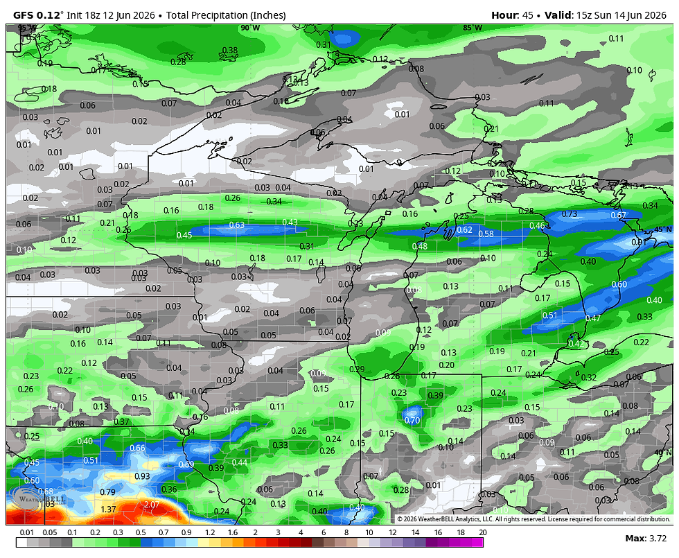
Late afternoon or evening scattered showers and storms are expected to develop ahead of a cold front dropping into Iowa from the northwest. While moisture does make a quick return and some CAPE is indicated, I don't expect much in the way of severe weather this far north. If anything with any kick develops it would most likely be in my far southern counties towards late afternoon or evening where some gusty winds are possible in the strongest updrafts. A few of the thunderstorms could produce spotty decent downpours but in general amounts should end up light to moderate due to the progressive nature of the front. Here's what models are suggesting for rain totals. The largest amounts are most likely in the south.
The EURO

The 3k NAM

The EURO

The GFS
Behind the system skies should gradually clear Sunday with temperatures noticeably cooler. Readings in the upper 60s to low 70s are expected to close out the weekend. Roll weather...TS


Had over 8 inches at my house this week T!!! That's enough!!!!😁 Good to see you back at it!!!!