

DIALING IN ON SIGNS OF WINTER...
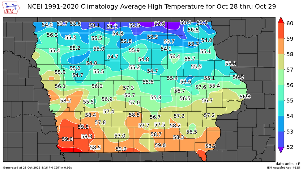
Before we get into the meat of some influential weather, especially next week, some thoughts on Wednesday's balmy conditions. For perspective, let's start with the normal Iowa highs for yesterday October 28th, which range from 55 in the north to 60 in the far south (and falling daily).
Compare that to the blow torch we saw Wednesday which shot highs into the range of 75 to 79 locally. While nobody established a record, most spots were within a few degrees. In Dubuque, the 75 degree high was just one degree short of the record max of 76 set back in 1945. Across the board, readings were 20-25 degrees above normal. To date in Moline, there have been 21 days of highs at 70 or above, producing a daily average October high of 73 degrees. On top of that, for most of my region it was the 12th consecutive "day" without measurable rain. Weather friends, this has truly been an October to remember in the very best of ways!

With 3 days left in the month, cooler temperatures will prevail. That said, nothing that will be too tough on the constitution. Highs the coming 3 days will generally be in the 60s, although Friday has the potential to be cooler in the mid to upper 50s north of I-80. Very respectable overall.
That brings us to the topic of rain, something we could all use a little of, especially with the harvest progressing nicely. As it stands now, showers and isolated storms from overnight will be dissipating Thursday morning with amounts generally around two 10ths of an inch or less, mainly west of the Mississippi. The remainder of the day Thursday looks dry. That's followed by another wing of warm advection showers (possible a few thundershowers) later Friday into Saturday morning. These could be heavier in nature with some spots near and north of I-80 picking up 1/2 to 1.00 inch of rain, heaviest where any thunderstorms can develop. The EURO shows this for potential totals from both events ending Saturday night.

Sunday see's a return to dry and warmer conditions with highs again poking into the range of 60 to 65 degrees. A nice way to roll into November!
A WET STORM STILL ON TRACK FOR MONDAY AND BEYOND...
While there is still some questions about the evolution of the storm there is good agreement on a slow moving cut-off low spinning out of the Plains into the mid-Mississippi River Valley. Water vapor reaches at least 1.50" inches which is quite substantial for November. With a closed system such as this, spokes of energy will rotate around the parent low fostering bands of rain that commence Monday and could last through Thursday. The bulk of the rain looks to fall Monday afternoon through Wednesday morning. After that, the precipitation turns lighter and more showery in nature.
Since there is still some doubt about the placement of energy and amounts, I'm using the ensembles of the EURO and GFS for potential rain totals. Instead of output from a single model run, as many as 51 solutions go into the final output of the EURO ensemble. Most members will be reasonably well clustered but some will be outliers due to more extreme tracks. At any rate, until guidance has a strong clustering, the ensembles are useful and generally more broadbrushed and lighter than a single deterministic run. Here's what the EURO ensemble shows for amounts Monday through Thursday followed by the GFS ensemble.
The EURO ensemble

The GFS ensemble

Below you can compare the deterministic GFS, a single run to the ensemble above. The numbers are quite a bit higher with no outliers to check it down. The value of the determistic output is that it shows the potential that exists once a single track is determined and it's too early for that.

Once the rain aspect of the storm departs, colder air will enter the picture, but its a bit slower than yesterday by a day or two. However, its eventually incorporated and the GFS and EURO show that in the 2 week temperature trends. Take a look.
The GFS

The EURO

I'm quite confident with the Arctic Oscillation (AO) going negative and the PNA (Pacific North America Oscillation) positive our temperatures will be trending sharply colder by mid-November.
The AO

The PNA

There's also a stratwarm unfolding around the Polar vortex. Overall, we expet a rapid and significant disruption and slowdown of the stratospheric Polar Vortex. The dashed red line is the historical minimum wind speed, and the latest forecasts all drop below that. This indicates we are dealing with a record Polar Vortex disruption for this time of year, with a stratospheric warming event.

The stratospheric warming anomaly is visible below on the ECMWF forecast for November 4th, where you can now see a split of the Polar Vortex into two cores, but still keeping the outer shell linked. This image also shows the temperature compared to normal, and as you can see, the stratospheric temperature wave will push temperatures almost 22°C (40°F) above normal at 10mb. When it's warm where it's usually bitter cold, the physical response is for the cold air to descend and move to the mid-latitudes. Since it's early and we have a very strong El Nino in play, the impacts are less certain than in mid winter. It certainly is another factor in favor of colder weather sometime in mid to late November.

As you can see, there is plenty going on that will have both short and long term impacts on our weather. After a beautiful October, November may not be so friendly. Time will tell. Roll weather...TS


Comments