

RAIN, WIND AND WARMTH
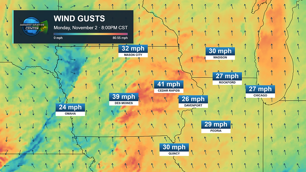
As showers cross through the region Monday afternoon, the air feels unlike the season. Blustery southerly winds will continue through the evening and overnight, gusting over 40mph at times, sending more moisture into the area with even more rain on Tuesday. Tuesday, Election Day, looks like a bit of a rough one for the area with wind and rain.

Showers and a few thunderstorms will continue through the evening and overnight, especially west of the Mississippi River. Rain chances will steadily increase west to east with time, with rain moving in Tuesday across northern Illinois.
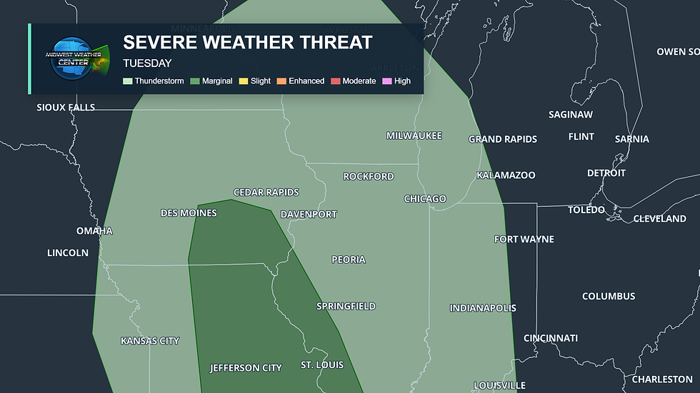
The official severe weather threat on Tuesday has been pushed farther north into Iowa. Right now it's a low risk, a Level 1 of 5 Risk (Marginal), but given some thunderstorm activity in the morning and the strong winds aloft, a strong storm capable of damaging wind is possible.
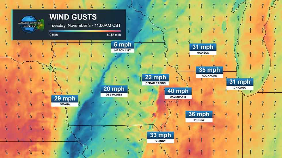
Tuesday morning will continue with strong wind gusts out of the south ahead of an approaching cold front. This will push temperatures into the upper 60s/low 70s before we see some changes heading into the middle part of the week.

Scattered showers and storms will continue Tuesday morning. Overall severe threat remains limited, but strong wind gusts will be possible with any organized convection. That would be the main hazard going into Election Day. The main severe threat likely wraps up by noon, with just lingering showers and a few rumbles of thunder through the rest of the day.

Overall rainfall is highly dependent on how organized thunderstorms are and where they exactly track. Some models, like the HRRR, are more than 1" of rain for the Quad Cities while other models like the RAP, RRFS and NAM are considerably less - below a quarter of an inch.
We discussed yesterday, the overall flooding threat is quite limited given the fast-moving nature of this system. Still, 0.5" to 1.0" will be possible for the region as this begins to exit early Wednesday morning.

Wednesday morning will have a chance of a few passing showers, but overall the rain threat appears to move well to the east by daybreak. The wind, however, will stick around behind our cold front.

Wind gusts will shift out of the west and northwest behind the storm system and still peak near 30-35mph at times. Not quite as strong as we had Tuesday, but still will make it a bit difficult for any high profile vehicles on the roadways. Despite the nature of this wind, this front is really not bringing in much in the way of significantly colder weather.

We have trended colder late this week, but still not terrible, with highs in the low/mid 50s instead of highs near 60. Overall more seasonal. Had this storm been later in the season it likely would have been quite a hit of colder air. Notice though, next week highs are likely to push right back into the 60s. This rather benign, warmer-than-normal pattern is continuing for some time.
Impressive warmth Tuesday!
We are seeing a hint at more action late November in the form of a disruption of the Polar Vortex (it's a thing, but let's not hype this up too much yet). A Sudden Stratospheric Warming Event (SSWE) is underway and will likely dislodge the air patterns WAY up in the stratosphere. This likely will have some implications on our weather patterns mid/late November. Historically, this would be much colder. However, given the state of our powerhouse El Nino, the exact implications of this SSWE are in doubt.

The official November outlook from the Climate Prediction Center is keeping our above-normal trend, and I do agree with this quite a bit looking at long term modeling. Snow lovers likely have some time to wait before we get into the action.

You may have seen some of the incredible flooding in Florida today. Thankfully, where I am at, we are high and dry in my neighborhood. I made sure when moving from Iowa I chose as close to the highest point in the area to pick our house. Stormy the Storm Chasing Corgi had a lot of fun on his morning walk in the rain, that's for sure.
Have a great week friends! Get out and vote!
-Meteorologist Nick Stewart


Comments