


FRESH SNOWFALL NUMBERS
- Nov 27, 2025
- 2 min read
LIVE WINTER STORM BRIEFING FRIDAY AT 8:00PM
Friday evening at 8:00, myself and meteorologist Nick Stewart will do a special Facebook live briefing on the holiday weekend storm which will be knocking on the door. We'll have the latest warnings, watches, and snowfall trends. Join us Friday night for an in depth perspective on the storm you won't find anywhere else. TS
For those with a need to know how our winter storm is progressing, here's the latest regarding fresh snowfall output from models, as well as current upgrades to warnings.
First, many of the winter storm watches that were issued last night have been converted to winter storm warnings today. Most of my counties in pink north of HWY 34 are in warning classification. Further south and east, winter storm watches remain in effect due to some minor uncertainties in track and thermal profiles. As you can see below, the NWS has left open the door to further warning expansion. The bulk of my area is looking at potential accumulations of 8–10 inches, with some banding potential for locally higher amounts.

Snow begins later Friday evening and could fall into late Saturday night. Moderate winds up to 30 Saturday night could produce some blowing and drifting snow, especially in outlying areas.
Here's the latest snowfall guidance from the intermediate 18Z model runs. Again, these are not forecasts, just raw model data that forecasts are derived from. That said, we are only 24 hours from the event, indicating high confidence that these numbers are close. The official NWS snowfall forecast looks like this as of Friday evening.
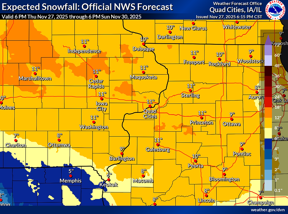
It also indicates odds of 8 or more inches are 95 to 99 percent near and north of I-80. Strong....

Heavy snow is expected to be widespread from Iowa into northern Illinois, southern Wisconsin, and Michigan. Travel in the yellow areas will be impacted and likely hazardous.

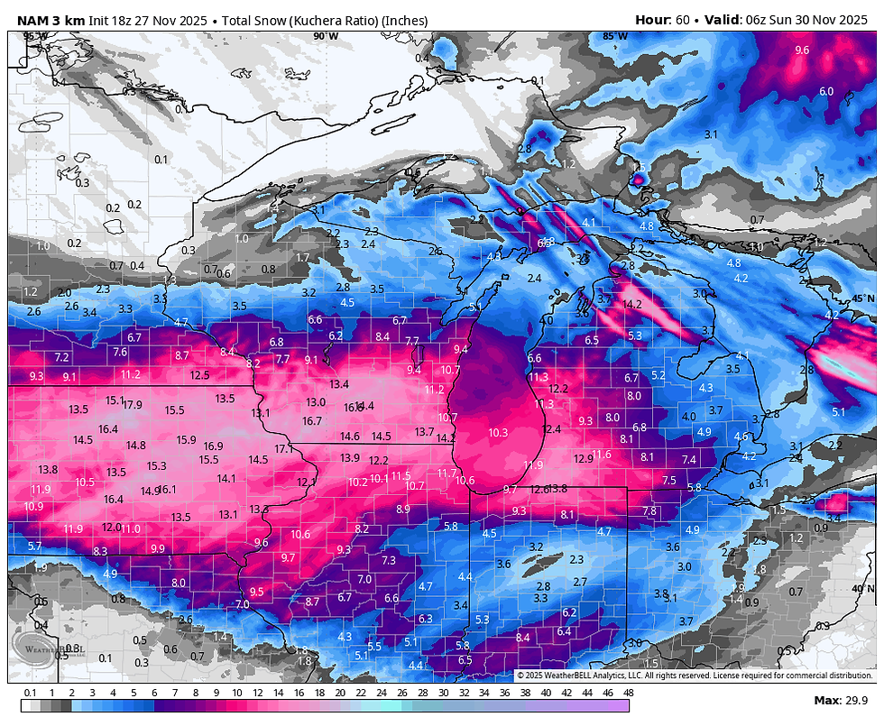
The new model output looks like this.
The EURO using the (Kuchera method) utilizing snow ratios higher than 10:1 which is likely, especially later in the storm.

This is the EURO ensembles at a straight 10:1 ratio. This is the average of 50 different ensemble members.

The GFS using Kuchera, higher than 10:1. Not as bullish as the EURO

The 3k NAM very aggressive and likely too high
The 12k NAM

The National blend v5 comprised of 30 different models and ensemble products.

That's the general idea, and it seems likely that even my southern counties under a watch will be converted to a warning at some point if these numbers hold up. I'll have something fresh out towards mid-morning Friday when the all important 12z models clear. Until then, I hope you all had an exceptional Thanksgiving. Roll weather...TS


I thoroughly enjoy your and Nick's daily detailed different model discussion and forecast. Winter and snow is nice but cannot wait for the 2026 tornado season.