


GETTING SET TO PULL THE PLUG...
- Mar 26
- 4 min read
Temperatures took off again Wednesday reaching the the mid to upper 70s (with Keokuk registering 81). Another mild day is on tap Thursday before a strong cold front drives substantially colder air into the region Friday. The persistent warmth has been in place since the official start of winter December 21st, impressive considering the snow and cold post Thanksgiving into the first two weeks of December.
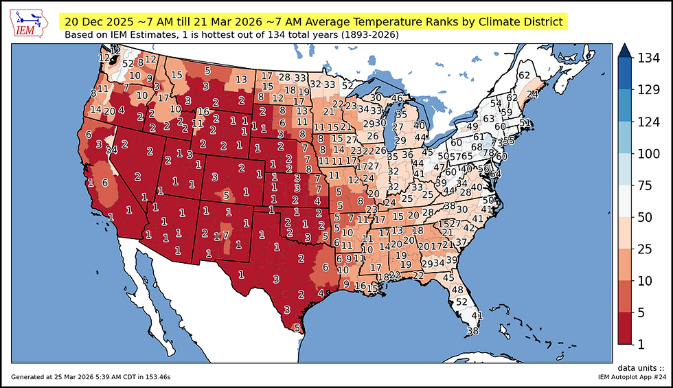
This graphic shows the average temperature departure for winter 2025-26.

In my immediate area, winter was ranked 17th to 23rd warmest out of 134 years. That puts it in the top 15 percent of warm winters. Western Iowa was in the top 5 percent coming in 8th wamest out of 134 years.

Here's what is really stunning. From California to Montana south into Texas, many locations had their warmest winter on record. The amount of real estate involved is vast and pretty much unprecidented.
Iowa high temperatures during March are running 8-10 inches above normal. You can't ask for much more than that. Two of the driving factors to date have been an abundance of dry air and an overall lack of snow cover.

As I mentioned earlier, we've got another warm one to enjoy today, but the mild air will be short circuited in the north by a stout cold front. It passes HWY 20 around noon and should be out of SE Iowa by 6:00pm. at the latest. The EURO shows temperatures at 3:00pm that look like this. An impressive 24-degree spread form 60 north to 84 south.

Even more challenging than the temperatures, will be how the front interacts with the afternoon moisture and instability that pools ahead of it. The integrated water vapor product shows a swath of pooled moisture around 4:00pm from the SE tip of Iowa extending into Illinois and Indiana.

That allows CAPE (instability) to reach 1,000 j/kg plus up to I-80.

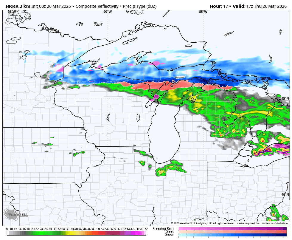
What CAP there is breaks around 4:00 near I-80 with storms quickly translating southeast with the front. This simulated radar off the HRRR shows the storms congealing into a line catching at least the southern third of my area. They should be out of the south by mid-evening.
The simulated infra-red satellite shows the coldest cloud tops and storm anvils at 7:00pm mainly from central Illinois into Indiana and Ohio.

There will be a short window for strong storms late afternoon and early evening, especially southeast of the Quad Cities. SPC does have a level 2 slight risk outlook that clips SE Iowa and western Illinois. An enhanced level 3 risk is out for EC Illinois into northern Illinois. I indicated yesterday, I thought that would end up being the case in central Illinois. That's where a wam front will enhance shear and surface based storms that could produce all modes of severe weather. I think my area avoids the worst of it. That said, the far SE will need to be watched as a slightly slower frontal passage could put that area into play for an hour or two. We won't know until we see mesoscale details unfold in the morning.

If nothing else, some spots in the south could end up with a shot at seeing some beneficial rains, in particular any location that can get under a thunderstorm. This is what models are indicating for rain potential. Little if anything looks likely north of I-80, and even in the south, meaningful amounts may end up being spotty.
The National Blend of Models

The 3K NAM

The HRRR

The GFS

The EURO

Once the front plows south of the region, much colder air will force any open windows to be abruptly shut across the area come Thursday evening. By Friday morning, readings will be back in the upper 20s north to the mid 30s south. Some passing cumulus, brisk NW winds, and temperatures in the 40s Friday will make for a pretty big shock compared to the 80s enjoyed in the south Thursday. Take a look.

Most locations will be 28 to 35 degrees colder Friday than just 24 hours earlier. See the departures below.

The coming weekend brings dry conditions and ample sunshine. Temperatures should bounce back too. Highs Saturday inch into the low 50s, and by Sunday, 63 to 68 is on the table from north to south. Next week 70s prevail Monday and we should be in the 75 to 80 range Tuesday. By then, showers and thunderstorms are back on the burner. Hopefully, we can all get in on a good rain at that time.
Enjoy the warmth of today, we pull the plug for a couple of days after that. Roll weather....TS

My sincere thank you to all of you who made contributions and have taken it upon yourself to support the site. TSwails is with you for another year. If you haven't contributed, and think the site has value, or you use it extensively, it is still possible to donate. Any contributions will go into a trust to be used to support the site going forward. Thanks again!


This is a reflective and thoughtfully written post that captures the emotional weight behind the idea of “pulling the plug,” presenting it in a way that feels both personal and meaningful. The article does a great job of conveying the complexity of such moments, where decisions are rarely simple and often involve a mix of emotion, responsibility, and acceptance. The phrase itself is commonly associated with withdrawing life support in critical situations, where difficult choices must be made with dignity and care . What stands out is how the post communicates this sensitive topic in a clear and relatable way, allowing readers to connect with the underlying message without feeling overwhelmed. The structured and balanced explanation makes it easier to…