


DANGEROUS, HIGH IMPACT WEATHER...
- Jan 21
- 5 min read
I'M ASKING FOR YOUR ASSISTANCE...

Hi everyone, as you know, TSwails.com is a no-pay site; existing on voluntary personal donations. Every year I ask those of you who find value in the site to make a financial donation you feel is worthy. Please reflect on the number of times you have visited us in the last year. If the information or knowledge you gained was valuable, it's my hope you will join the loyal group of contributors that's kept TSwails.com operational since 2013. I'm suggesting $20.00, which is roughly a nickel a day. Less than 4% of my readers donate, so your gift, no matter the size, is not only appreciated, it helps immensely.
PLEASE CLICK HERE TO ASSIST
THE MANITOBA MAULER
We all experienced a healthy shot of Arctic air Sunday night and Monday, but I'm afraid to say it was little more than a taste compared to what's to come by the end of the week. A double barreled Manitoba Mauler is on the move with its eyes set on the Midwest. The "mauler", is a type of weather system originating in Manitoba known for rapid movement, frigid Arctic air, and hazardous conditions, even if snow totals aren't much more than a dusting.
I'm going to show you an animation of the 500mb upper air pattern that's expected over the next 5 days. You can see the initial vortex drop south through Manitoba and then spin southeast towards Lake Superior. That draws true Arctic air into the region Thursday night. Not far behind, another closed circulation forms in Manitoba Friday night that ends up over NC Minnesota Sunday. Watch them dance.
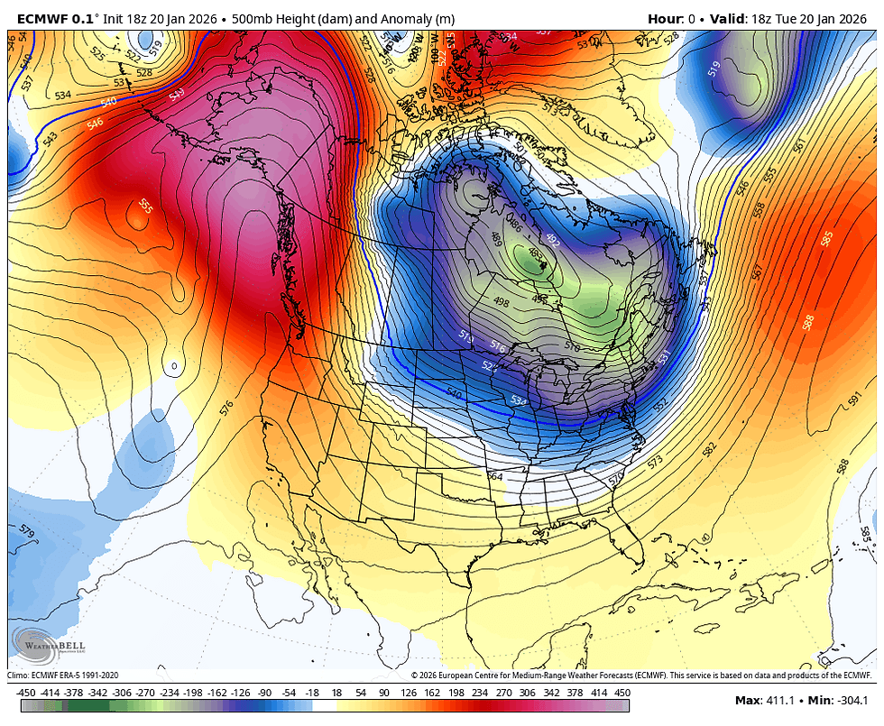
The first phase of this was very much on our radar the past 5–6 days and will be responsible for dangerous cold Thursday night and especially Friday. A new twist is the second disturbance, which is now shown digging further SW. That allows some phasing with a southern stream system ejecting out of Arizona. The process has the potential to bring snow into the region Saturday night into Sunday. This system will become a major weather event just east with heavy snow and ice expected there, we should be on the NW flank of it. Of more importance is the fact it will reinforce the Arctic air in place and keep the Midwest in the deep freeze into the first half of next week.
Getting back to the first mauler, it actually brings a surge of warmer air Wednesday, allowing a weak surface low to travel along I-80, allowing temperatures in that part of my area to warm into the mid to upper 30s. North of I-80, a colder air mass resides, where highs should largely remain in the mid to upper 20s.

Additionally, enough warm air advection and forcing exists for another swath of light snow, especially north of HWY 30 late in the day or evening Wednesday, where an inch or so is possible. In addition, wind gusts up to 40 mph are expected with the passage of an Arctic cold front. The combination of strong winds, falling snow, and fresh snow on the ground will lead to a period of blowing snow and reduced visibility. Therefore, while new snow will only be around an inch, impacts to road conditions and visibility are likely, especially in rural areas. A Winter Weather Advisory has been issued for the northern 2 tiers of my counties, generally north of HWY 30 from 5:00pm to midnight. The remainder of my area will be under a Wind Advisory for wind gusts up to 45 mph from 2:00pm until midnight. Beyond that, all of my area is now under an Extreme Cold Watch late Thursday night into Saturday for dangerous wind chills of 30 below or colder.

HOT DEALS INTO FEBRUARY....

SNARE A WEEKEND, (4 GUESTS FOR $499 total) My AIRBNB outside of Galena is ready and waiting. Enjoy our unique, fully renovated church. It's an AIRBNB guest favorite with 5-star reviews. Warm and cozy, even in the winter. Minutes from Galena. Call or text Carolyn at 563-676-3320 for details about this very special deal. https://www.littlewhitechurchgalena.com/
KATIE BAR THE DOOR...
Once Wednesday nights snow departs in the north, colder air arrives, but only moderately so Thursday itself, as the wicked cold is still surging south into the Dakotas. Highs again should see a decent range from the mid-teens north where snow cover will have an impact, to the lower 30s south without it. Thursday evening, the polar air mass hits, the winds explode, and temperatures free fall.
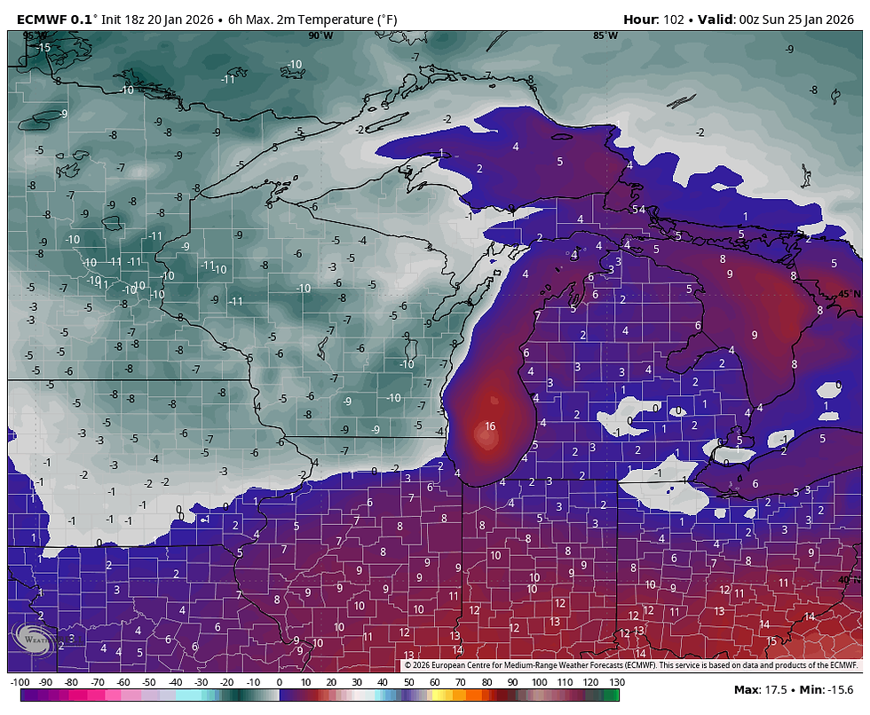
In the animation below you can see the relatively seasonal air of Wednesday and part of Thursday getting destroyed with temperatures crashing to levels nearly 40 degrees below normal in purple.

These are temperature departures the EURO shows at noon Friday. Relative to average, these readings are the coldest in all of North America.

Actual temperatures on the EURO Friday morning are as cold as 20 below in the north. More like 10-15 below south of I-80.

Where it gets really nasty is with the addition of NW winds, which will likely gust to 30 mph. That combination should generate wind chills of 30 to perhaps 40 below zero in the north. Dubuque is shown with a wind chill of minus 40.

The threshold for Extreme Cold Warnings at the NWS, ranges from 25 below in the far south to 30 below over the rest of my region. This more than meets the qualifications.

Below is a break down of the thresholds necessary for extreme cold warnings in the immediate region.

Here's something that I find really fascinating, it's the temperatures that the EURO depicts at noon Friday. Most of the area north of I-80 is 10 to 15 below zero. Considering those readings are occurring close to peak heating, that is off the charts cold for that time of the day. Clearly, the core of the Arctic air mass is overhead.

Fortunately, with the next round of energy set to arrive, we get a tiny dose of warm air advection that keeps temperatures fairly steady Friday night. That produces lows Saturday morning that are not much colder than highs Friday. A small blessing, but still ugly.

Saturday, between maulers, we can expect a quiet but very cold day. The EURO keeps highs in the range of 5 below north to 5 above south.
Sunday, a potent over-running situation develops that according to the EURO, has us situated on the NW fringes of the system. That's a place of low confidence at this juncture, since a shift in track north could bring more snow, a swing further southeast spares us that hardship. Being on the edge and still several days out, there's not much to say other than this bares close watching.
Currently, the operational EURO shows this for snow totals Sunday, which is a huge change from just 24 hours ago.

The operational GFS with less phasing, swipes it all well off to the southeast. Since phasing is involved (something models struggle with), and 2 dramatically different solutions exist, I have to defer to later model runs to get a secure handle on how this plays out. Due to the depth and strength of the cold, the EURO may be too far northwest with its snow reaching back into eastern Iowa. More to come.

Wherever it ends up, this is going to be a high-end snowfall event for much of the country from the Plains into the Ohio Valley and points east.

One thing we will not miss out on and is a high confidence impact is cold air, which will be around in some form of intensity much of next week. Don't you just love the Midwest? Roll weather...TS


Comments