I SPY WITH MY LITTLE EYE...
- May 22, 2021
- 2 min read
The outlooks for June and the summer as a whole have been issued by NOAA and the Climate Prediction Center. Here's what the experts in the U.S. are projecting for the next few months.
Starting with June, this is the outlook for both temperatures and precipitation. If the folks at CPC are right, odds are pretty good for above normal temperatures and near normal rainfall.

Expanding the outlook to the summer months of June, July, and August, we come up with an outlook like this for temperatures. The consensus is for near normal readings over most of the Midwest. The rest of the country is warm.

Precipitation for the 3 month period also falls into the the category of normal.

To sum it up, if CPC is reading the cards right, the summer ahead should be near to slightly above normal on temperatures and near to maybe a bit below normal on precipitation. My personal feelings for summer lead me to lean towards slightly below normal temperatures and near to below normal rainfall. Overall that's a deal worth taking.
Leaning way over the cliff, here's what the EURO indicates for the upper air pattern November through January. The west coast ridge would indicate cooler than average temperatures and near to above normal snowfall here in the Midwest (and much of the east). If you like winter that's not a bad look. It's too early to put eggs in a basket but this is a pattern that would be winter friendly. Food for thought!

As far as Sunday and Monday is concerned, I don't see much in the way of change meaning a mixture of clouds, sunshine, and a continuation of warm muggy conditions. Here and there an isolated shower or thunderstorm is possible but chances are slim and most areas will stay dry.
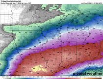
Tuesday a front enters the picture and with it will come better chances for showers and storms on a more organized basis. Depending on timing and overall dynamics the potential exists for some areas to see locally heavy rains, especially towards the middle of next week. Models are still struggling a bit to get a hold of the pattern and its rain potential. We should have a much better handle on the overall scenario later Sunday.
Meantime, it's pretty much steady as she goes Monday and perhaps even Tuesday so what you see is pretty much what you get. Roll weather...TS


Comments