NO REST FOR THE WICKED...
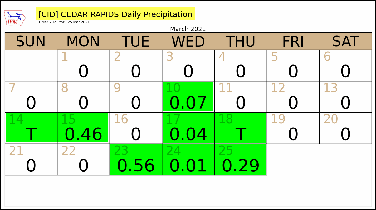
March is well known for its ability to change seasons on a dime. As the warmth of spring makes its first intrusions into the remnants of winter, the Midwest becomes a battleground for storms to thrive, often on a regular basis. We're in one of those patterns now where rain has fallen 8 of the past 16 days in much of my area. Here's the daily March precipitation totals for Cedar Rapids

Today, any rain will be confined to the early morning hours as the latest storm pulls away. That will leave us with a better weather to start the weekend but clouds will likely hang tough much of the day. Even so, temperatures should warm some into the upper 40s north to mid 50s south, perhaps as much as 8 degrees warmer than yesterday in spots.

The window for dry weather is short however with another disturbance bringing rain and possibly a few rumbles of thunder back into the area Friday night. The system is progressive ending the rain Saturday morning. By then, another 1/4 to 3/4 inch of precipitation is likely. The EURO is further southeast on the heavier totals than the U.S. models. I'm leaning that way at this time. Here's the rainfall forecasts of both models along with the NBM blend of solutions.
The EURO

The GFS

The NBM blend. I don't see much support for this solution.

Assuming the system moves along as expected, Saturday afternoon may actually turn out respectable with some breaks for sun and temperatures in the southern half of my area pushing 60. Here's hoping that works out.

By the way, if the EURO verifies its readings would be 5-10 above the norms.

As a cool front dips back into the area towards Saturday evening, a few showers could re-develop but they are light, short in duration, and gone by Sunday. The weekend closes dry but a bit cooler with high pressure parked overhead.
With the high moving east of the region Monday, a strong return flow of southerly winds will allow a big warm-up. With ample sunshine and dry air temperatures could really take off and it is not out of the question a few places could out perform model guidance. If so, that would elevate highs in some spots close to or even above 70. As it is, the EURO shows this for highs.

That would bring readings 15-25 degrees above normal across the upper Midwest. The drawback will be the winds which could easily gust as high as 40. The price you pay for highs near 70 in March!

Enjoy the Monday warmth, a fairly stiff shot of cool air will follow for a few days the middle of next week. It doesn't look prolonged but it will get your attention while it's around. No rest for the wicked. Roll weather...TS


