


RECORD COLD, NOT WHAT THE DOCTOR ORDERED...
It's a holiday weekend, the first in 5 months. Nothing like celebrating with frost and a round of record cold temperatures for everyone. To be honest, bouts of cold have been a regular feature of our weather since the start of 2021. Here's the yearly temperature departures since January 1st.

The cold we are currently experiencing was well teleconnected and comes as no surprise to me. For over a week the MJO (Madden Julien Oscillation) has been showing the transition to phase 7, one that's known for producing cool temperatures in both May and June. In the phase diagram below you can see by following the dotted green lines the MJO progression into 7.
Notice the temperature analog for phase 7 in May and especially June. The predominance of cold certainly fits the pattern we have entered.
By the way, you early risers are likely seeing frost Saturday morning. A frost advisory is out until 7:00 AM from roughly I-80 north. That's where temperatures are expected to be the coldest, even though scattered frost is possible all the way to the Missouri border.
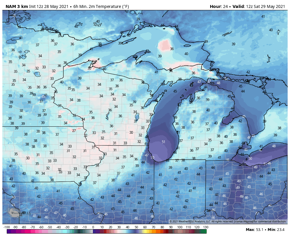
If the 3k NAM has its way, readings around 7:00 AM Saturday should look like this. Those would be good enough for record lows in most reporting stations. Here's what we have to reach to establish records for May 29th. How soon clouds depart will determine if we make it or not. It will be close!
31 degrees, Dubuque
34 degrees, Cedar Rapids and Quad Cities
36 in Burlington
By the way, this comes on the heels or record cold highs on Friday. The high of 46 in Dubuque and 49 in the Quad Cities broke or tied the previous marks which were 48 in Dubuque and 49 in the Quad Cities, both came in 1965.
With a dry high pressure in place conditions will be fine for outdoor activities the rest of the weekend, just plan on cooler than average temperatures by 10-15 degrees. That should keep us in the low to mid 60s through Sunday. Memorial Day we may make a run at 70 but the amount of sunshine will determine if we can get there or not. Some models are indicating more clouds than others. None the less, all models are keeping it dry through Monday. It won't be beach or pool weather but at least you can get outdoors.
After we get through some cool, unsettled weather next week, the MJO is expected to depart phase 7 and that should bring us warmer conditions for next weekend. Notice how the 500mb jet flattens and is beginning to veer southwest as a ridge builds over the SC United States.

That brings 5 day temperature departures that look like this June 4-9th. I'll be ready for that.

By the way, from the "things could always be worse vault", look what happened on this date in 1947. The article and graphics are complements of the NWS La Crosse, Wisconsin.

Through the years, this late season snow storm has been purged from memories of many people in northeast Iowa, southeast Minnesota, and western Wisconsin. Maybe it is that people do not want to think about snow in late May or that the snow quickly melted, but very few remember this storm. If it was not for this author stumbling upon a 9 inch snow amount in Viroqua, Wisconsin this reminder that snow storms can occur this late in the spring in the Upper Mississippi Valley may have never been written.
On the morning of May 27, 1947, a developing low pressure system was located over central Nevada. It was this low which would be responsible for the snow storm over the Central Plains, Upper Mississippi Valley, and Upper Michigan from May 27th through May 29th. A strong arctic high pressure system was located over the Mackenzie Basin in northwest Canada. This high would provide the cold air needed for a winter storm to develop. A mixture of rain and snow developed over Colorado and Wyoming during the day on May 27th and changed to all snow during the night as the low deepened and moved slowly east through southern Colorado. On the morning of the 28th, the high pressure center had moved rapidly south to southern Saskatchewan. This high pressure area brought unprecedented cold for late May to North Dakota. Temperatures fell to as low as 15 degrees at Eckman, which is located near the Canadian border. In addition, the mercury fell to 23 degrees at Bismarck which is the lowest ever recorded there after May 20th. Meanwhile, below freezing temperatures were found across Montana, Wyoming, northeastern Colorado, western Nebraska, northern Minnesota, and western South Dakota. The sub freezing temperatures caused a partial to total loss of fruits and tender plants. During the day, this cold air surged southward across eastern Nebraska, eastern South Dakota, Iowa, southern Minnesota, and Wisconsin. Many cold maximum temperatures were established across the region for the day. At the same time this was occurring, the area of low pressure was continuing to strengthen as it moved east through southern Kansas. From the evening of the 27th through the 28th, this low produced a 6-12" snow band from southeast Wyoming east across northern Nebraska into northwest Iowa. The heaviest snow in this band was found in Alliance and Harrison, Nebraska where 12" had fallen. The weight from the heavy wet snow caused considerable damage to power lines, telephone lines, telegraph lines, trees, and shrubs. During the late afternoon and evening of May 28th, the surface low began to move northeast across northern Missouri, northwest Illinois, and southeast Wisconsin. The reason for this change in direction was due to a strong upper level disturbance that had dropped into the base of the upper level trough over Nebraska during the day. This upper level disturbance caused an amplification of the upper level ridge over the Ohio Valley and much of New England. As a result, temperatures in this region climbed into the 80s instead of the 50s and 60s which were seen the day before. However on the cold side of the system, temperatures remained in the 30s and 40s in the Upper Mississippi Valley. In addition to the cold temperatures, rain changed to snow across southern Minnesota, northeast Iowa, and across much of Wisconsin. This was the latest snow ever reported in a season in this area, with some places experiencing their biggest May snow storm on record. From the late afternoon of the 28th into the early morning hours of the 29th, 7-10" of snow fell across Allamakee County in northeast Iowa, and Vernon, Crawford, southern Monroe, and Richland Counties in southwest Wisconsin. The heaviest snowfall amount was 10" in Gays Mills, WI. Meanwhile, a 7-9" band of snow fell across northern Adams, Waushara, Winnebago, Outagamie, and Waupaca Counties in central and east central Wisconsin. The weight of the heavy snow caused severe damage to power lines, telephone lines, bushes, and trees.
Well, I guess we can be thankful we don't have to deal with that. Ride low, stay warm, and enjoy the holiday! TS


