REVERSE SPRING...
- Apr 20, 2023
- 3 min read
We're into the time of year when normal highs have risen into the low to mid 60s. A little dab of sunshine and a south wind is about all you need to crack 70. We're marching towards summer and that pinnacle of warmth is in sight. But see it as we may, there's a big valley to navigate ahead in the form of a chilly pattern more reminiscent of March than late April.
Teleconnections certainly are leading the way with the upcoming chill with the MJO making a beeline for phase 1 where it resides for nearly a week. As you can see in April phase 1 strongly correlates to well below normal temperatures.

The AO (Arctic Oscillation) is significantly negative as well.

That's important in that it implies blocking, (or high pressure) at high latitudes. You can see it in the reddish orange colors below. That forces the cold air that resides there southward into the mid latitudes where we reside. Lucky us!

The EPO (eastern Pacific Oscillation) is also trending strongly negative in the long range when the MJO enters its tour of phase 1.

Note how the negative EPO builds a western ridge favoring cold over much of the nation east of the Rockies.

Adding insult to injury is the NAO (North Atlantic Oscillation). The blocking that results over Greenland promotes cold air intrusions over the central and eastern U.S.

When you look at the 5 day temperature departures for the period April 22-27 (when the MJO is in phase 1) you can see by way of temperature departures how all the teleconnections in harmony produce wide spread cold across the mid-latitudes. Blocking in Greenland and the northern latitudes is readily apparent too. That's a text book case displaying the value of teleconnections as long range pattern drivers.

This meteogram shows the high and low temperatures on the GFS through May 4th. That's spring in reverse if I've ever seen it. I suspect this run is too cold too start May with all those 40s. I certainly hope so as a 32 degree low May 4th and a 46 degree high the 5th is WRONG in every conceivable way!

ONE HOT DEAL... 3 NIGHTS FOR THE PRICE OF 2 MEMORIAL WEEKEND IN GALENA

THE LITTLE WHITE CHURCH AWAITS YOU
Get the gang together. Kick off summer with a free night at the church, one of the most unique stays in the Midwest. Call Carolyn at 563-676-3320 or email carolynswettstone@yahoo.com CLICK HERE
MORE STORMS BEFORE THE CHILL?
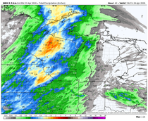
Before we get into the weekend chill, we await the cold front that will deliver it. It has produced scattered showers and storms overnight and some of those will linger into Thursday morning. There remains a chance that any that remain could produce some hail and heavy downpours.
What happens in the afternoon will be determined by the speed of the cold front and the ability for the atmosphere to recover from any morning clouds and convection. The window for anything severe would be short from about 3-7pm from west to east as the front swings through.
The 3K NAM does get highs back in the 60s and low 70s

That combined with dew points in the low to mid 60s would generate some decent CAPE according to the HRRR.

That signifies the potential exists for some strong storms but it will be a race against the front which could get through my western counties before anything could fire. The area from about the Mississippi east has the best chance of seeing anything strong, including all modes of severe weather such as wind, hail, and tornadoes. We really won't know until mesoscale details become clear Thursday morning. There's low confidence on the threat as of late Wednesday night.
After that, the door is wide open for a burst of cold air that initiates the cool period discussed earlier in this post. Saturday looks to be the coldest day in the short term with highs of 40-45 from north to south. Those readings are a solid 19-23 degrees below normal.

With 850 temperatures of -8 (at 5,000 ft.), strong lapse rates will exist between there and the surface creating plenty of wind and instability. Scattered but brief rain or snow showers are possible, especially in the north. Overall, it just looks to be an extremely sub-par day with highs of 40-45 degrees. Sunday doesn't look much better.
Well, that's the long and the short of it. Until next time, roll weather...TS
A MESSAGE: Voluntary donations from people like you support the content, infrastructure, and operational cost of this site. Your contribution however small, makes a big difference. Please consider a donation, and thanks to the 416 of you who have answered the call. It is greatly appreciated. Just click the banner to make a voluntary donation. TS


Comments