SHORT TERM RELIEF, LONG-TERM OUTLOOK
- Oct 5, 2025
- 3 min read

The heat is almost out of here. Sunday is the last hold out before we go from well-above-normal to just above normal by next weekend. We'll call it "seasonably warm" with one, brief break from the warmth in between. The good news? There are signs the pattern will get more amplified, active and therefore cooler mid-to-late October. Late this week you can see there are chances for near-normal to slightly-below-normal locally.

The model blend shows some cooling temperatures Tuesday behind a cold front before we slowly moderate back to the warmer side of things by next weekend. We, in-fact, actually see the potential for 80s returning. Let's focus on that refreshing upper 60 Tuesday high though, and Wednesday morning lows in the mid-40s.

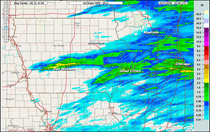
High-resolution models show scattered showers and thunderstorms from southeast Minnesota through central Iowa and southeast Nebraska Sunday evening and overnight, capable of locally heavy rainfall. A storm or two could be strong with damaging wind gusts being the main concern, however that should be rather limited.
The thunderstorm risk and heavier rain will likely be west of eastern Iowa and the Quad Cities region.

Monday, as the cold front slowly sweeps through the area, there will be scattered showers and locally heavy rain, but widespread beneficial rain is unfortunately going to be hard to come by. We have slipped into drought across much of the area and this rain is not expected to put a dent into that.

Sunday/Sunday evening the heaviest rain will be out west and northwest of the area. The high-resolution model ensemble has some areas peaking near 1", especially in central and southwest Iowa before it's all said and done.

The forecast from the model blend through Tuesday afternoon brings at least some rain locally, this would mainly be with showers on Monday. I think for eastern Iowa and northern Illinois this is a bit of a best-case scenario near 0.25" to 0.50". Hoping for the best!
The EURO

The GFS

The main global models show a similar outcome with the rain. Again, scattered showers are likely Monday locally but likely not capable of producing the heaviest rain.

Looking long term, I want to build on what Chief Terry discussed yesterday. He went the MJO route, I am going to go the NAO (North Atlantic Oscillation) route and both are indicating similar scenarios deeper into October. The NAO is projected to take a pretty big dip negative through mid-Month October which is a somewhat beneficial signal for cooler temperatures and a more amplified pattern. A value approaching -1.5 is a rather important value when considering the NAO.

Since 1950 there have been 10 years that the entire month averaged at least -1.7. I will use these Octobers as an analog for what is looking somewhat likely for mid-October, and they show a somewhat high-confidence forecast for below-normal temperatures for the Midwest and Great Lakes region. So, at least some eye candy while we deal with another day of highly-unusual warmth.

Prior to this next pattern shift there will likely be another warmup midweek next week (Oct. 13-15) before some signal to a cooler trend in temperatures following that. The 850mb temperature anomaly isn't particularly strong at this time, I would not be shocked if this trends cooler over the next several days given the teleconnections.

Long-range GEFS shows a subtle signal for above-normal precipitation in the long range with this change in pattern the teleconnections are trying to signal. Some additional precipitation prior to the first freeze would be ideal to lock some soil moisture in place.
While the Midwest is dry and hot, Florida has been wet and cooler than normal with a tropical disturbance setting up this weekend. Stormy the Storm Chasing Corgi and I took on some of the waves and torrential tropical downpours today! Hopeful I can share some of this with you all.
Have a great rest of the weekend!
-Meteorologist Nick Stewart


Comments