


"STEPPING" UP TO THE PLATE
- Mar 28
- 3 min read
To say Friday was a deceptive day weatherwise is a bit of an understatement. The sun was out and the sky was blue, a looker from the comfort of my house. However, a short trip out to the curb to pick up the recycling bins told a different story. A 35 mph NW wind and a temperature of 39 took much of the pleasure out of the overall aesthetics.
While Friday's temperatures were below normal, days like that have been in the minority this year. Since the start of 2026, the NWS office in the Quad Cities has had 58 of its 84 days registered as above normal (that's a 70 percent rate). 20 of those 58 days were at least 20 degrees above normal, which qulifies as high end departures.

STEPPING UP AGAIN...
While Saturday promises to be another cool day, temperatures will start stepping up with the return of SW winds in the afternoon. We will have a long way to go to reach highs of 50-55 after morning lows ranging from 19-24 degrees. The HRRR shows this. Hopefully, that's the last time we see lows this cold again until late next fall.

As Saturday unfolds, we will see some amplification in the 500mb jet stream flow ahead of our next weather maker Tuesday. With W/SW winds evolving, warm air advection will earnestly commence Sunday and continue through Monday and early Tuesday. That draws in our next surge of above normal temperatures.

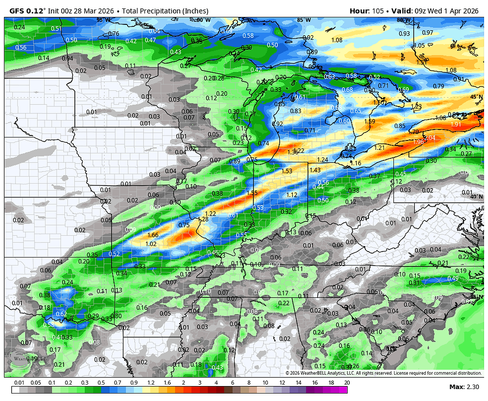
Highs will go from 65 to 70 Sunday, to 75 to 80 Monday. With time, moisture will eventually inch back into the pattern leading to the chance of scattered showers and thunderstorms Monday night into Tuesday morning. Timing a frontal passage will be crucial as to how much rain we get out of the set-up. The EURO has the front passing Tuesday morning into early afternoon which is not optimal for rain potential. Once again, this could be another narrow miss due to little more than bad timing. It will take a couple more days to get a strong handle on the situation. Meantime, here's what early solutions point to for rain potential.
The EURO

The GFS
The National Blend of Models

This will all be followed by another cool-down the middle of next week before readings again rebound. This is the typical push pull effect of the seasonal transition from the remnants of winter to the growing warmth of spring. We'll see plenty of these ups and downs in the next month. In fact, the EURO meteogram through April 11th, depicts 3 different spikes where temperatures peak in the 70s over the next 15 days.

Rainfall remains a concern and while others around us have seen their share over the past couple of weeks, we keep coming out with the short end of the stick. Even so, the ensembles of the EURO and GFS continue to point towards beneficial rain in the coming 2 weeks. Here's the EURO 51 member ensemble mean through April 11th.

The GFS ensemble mean looks quite comparable for the same period.

In summation, Saturday is a tweener as we ride the edge of chilly high pressure to the east and warmer low pressure developing out to the west. Seasonal highs of 50-55 are anticipated before warmth wins out again Sunday and Monday. Make it a great weekend and roll weather...TS

My sincere thank you to all of you who made contributions and have taken it upon yourself to support the site. TSwails is with you for another year. If you haven't contributed, and think the site has value, or you use it extensively, it is still possible to donate. Any contributions will go into a trust to be used to support the site going forward. Thanks again!


Comments