

STILL GREEN & GROWING...
Here we are November 6th and so far, no killing freeze. Flowers are blooming, the grass is green, and like it or not El Nino is largely to blame. El Niño by the way, is a natural climate oscillation characterized by the warming of ocean surface temperatures in the central and eastern tropical Pacific. It alters the path of the Pacific jet stream, often producing a split flow with minimal interaction from the northern branch here in the Midwest. That restricts cold air intrusions and keeps the southern stream dominate. That allows westerly flow to transport unseasonably mild air into the U.S. weather pattern. El Niño years frequently bring above average temperatures, especially across the northern tier of the nation during the winter.
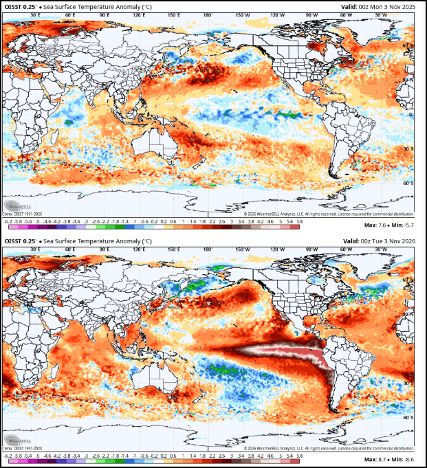
Below you can see the extent of the warm water anomalies extending from the central Pacific into the south American coast. Currently, this is the strongest El Nino since the onset of records in 1950.

Below you can see a comparison of last years sea surface temperatures at this time to where we are now in 2026. In 2025 in the same region of the Pacific sea surface temperatures were actually colder than normal resulting in a weak La Nina. Note the strong contrast between the two in just one years time.
This years El Nino developed early and has contributed substantially to our exceptionally mild and pleasant conditions. Below are the North American temperature departures over the past 90 days (3 months). Virtually all of the continent has experienced above average temperatures with some of the largest departures right here in the central U.S. Globally, 2026 will likely end up as the warmest year on record.

SOME THOUGHTS FROM THE IOWA STATE CLIMATOLOGIST
Iowa State Climatologist Justin Glisan had this to say about our warmth and lack of a hard freeze in a recent Radio Iowa interview. “With 154 years of records, preliminarily this is the third warmest October on record,”
Due to those warmer temperatures, the first frost in Iowa has been delayed.” "One of the latest first fall frost and freeze events that we’re seen in recorded history,” Glisan said. “Generally by the first or second week of October we have seen widespread frost or freezing temperatures, with a killing freeze occurring at 28 degrees. It wasn’t until about the 17th and 18th that parts of Iowa saw their first below freezing temperatures". While frost was observed, the coldest readings of 31-32 were mainly confined to the north and were not sustained long enough to end the growing season.
Glisan also noted that statewide average October precipitation in Iowa was three-tenths of an inch above normal. “Portions of central Iowa along with a swath of western into northeast Iowa saw above average precipitation, but overall, after a very wet September, still trended slightly above average,” Glisan said. “So if you look at meteorological fall to date, September and October, 2026 is coming in around the fifth wettest and the fifth warmest on record.”
Just a few pockets of “abnormal dryness” remain in north central Iowa according to the latest Iowa Drought Monitor. “The very wet conditions that we had in September and October were a ‘drought buster,’ so going into next growing season we’re not going in dry, definitely. We’re going in near normal and that’s been a shift from the last several years,” Glisan said. “The 2020s have been a particularly dry decade for the state and many other states in the upper Midwest, so seeing this rainfall in September and October really helped push back on those longer term deficits.”
FROST ON THE REMAINING PUMPKINS
Now that we've established the fact we've avoided a freeze so far this fall, Friday night may be the night parts of the area get the job done. As a rule, 28 degrees is the threshold to reach. As it stands now, clouds should begin to erode Friday as high pressure finally delivers drier air. That's important as it clears skies and diminishes winds Friday night. With highs not expected to get out of the low to mid 40s Friday, it won't take long for temperatures to reach the freezing mark later in the evening. The HRRR shows readings around daybreak eventually falling into the range of 26-30 areawide. I would not be surprised if a few of the typically colder low lying areas reach 24 or 25. Expect plenty of frost and certainly some ice on the bird baths. A freeze warning is likely to be issued for many.

After a cold start Saturday, dry weather locks in with a warming trend that last into early next week. Highs will go from 50-55 Saturday to 58-63 Sunday. Monday looks downright balmy with highs of 62 to 67. Tuesday should be similar. Considering typical highs range from 46 to 50 by then, we'll be living high on the hog once again. Why not! Roll weather...TS


Comments