


THE ONLY GAME IN TOWN (LIVE UPDATES ON MAJOR MAINE SNOWSTORM)
- Dec 5, 2020
- 3 min read
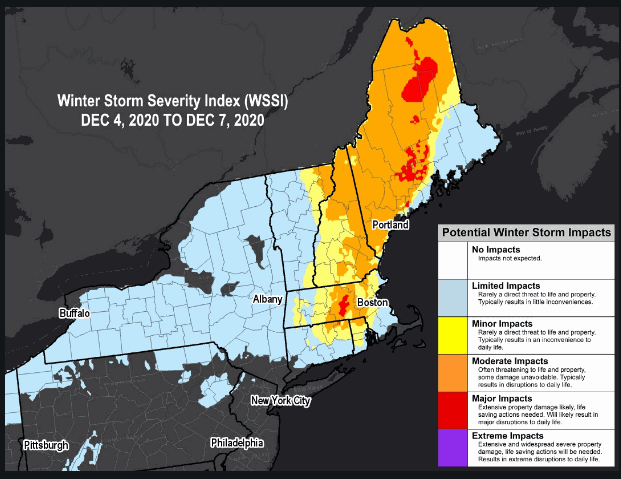
The only game in the weather world Saturday will be the one played in my backyard. That's the nor-easter that's expected to spin up off Cape Cod and roar up through the Gulf of Maine Saturday night. As I post this article, winter storm warnings are up for much of the state for snow that could be in the the range of 6-18". It will be a wet snow with winds that could gust to 45 or 50 , especially along the coast. Blowing snow won't be the issue it could have been due to the wet heavy nature of the snow, however combined with the wind it is likely to cause power outages and some low visibility during the heaviest snow bands. The Winter Storm Severity Index is in the moderate to even major category in spots. Major indicates significant disruptions to daily life.
Here are some of the higher end snowfall totals that are possible from the NWS in Portland, Maine. I've seen models with up to 24"

There is some concern that along the coast where I'm situated that there could be a mix with rain or even a change-over to rain before it flips back to snow. That makes the snow forecast here tricky but just inland it is going to be a beastly storm with the central pressure dropping to 975 MB, The 3k NAM just came in with a 10 meter wind gust of 62 in Portland and 71 on the north tip of Cape Cod.
LIVE FACEBOOK UPDATES...
I thought it would be fun to bring the storm back to you in the Midwest and I plan to do regular live Facebook updates once it kicks in Saturday afternoon and evening. I'm not sure if I will remain in Portland or head inland 30 or 40 miles. That will depend on the morning models, their thermal profiles, and how the snow bands lay out.
IMPORTANT, 21 DAYS UNTIL CHRISTMAS, WHAT ARE YOU WAITING FOR?

There's still time to get my new book Derecho 911, Iowa's Inland Hurricane. Order by December 16th and get yours by Christmas. It's a thoughtful gift from Santa that will be appreciated by that hard to buy for individual. The book is coffee table style and color with more than 100 pictures, images, and graphics that I guarantee is entertaining, well researched, and very informative. For more info or to obtain your autographed copy please click on derechobook.com
As for the weather in the Midwest this weekend, consider it trouble free. Temperatures while cool will be near 40, slightly above normal. Skies are expected to be mostly sunny so put up those Christmas lights, go get that tree, and do your shopping with a sweatshirt or light coat. Mother nature is in a good mood and so am I. Roll weather...TS
WHITE CHRISTMAS WATCH
With Christmas just over 3 weeks away I'm continuing a feature called white Christmas Watch. I will try to put the ensembles of the EURO, GFS, and CANADIAN GEM up on a regular basis to give you an idea of what the models are showing for snow potential approaching Christmas. I do want to stress these are absolutely NOT forecasts and are not intended to be taken as such. Ensembles are an average of numerous solutions, some with more snow and often others with none at all. However, the average gives forecasters an idea of where trends are heading. When all three models are showing 6 or more inches in a given area that is a strong trend and one that probably has merit. 1-2" is low end and nothing to bank on. Just wanted you to see what I see behind the scenes and thought you might find it fun to watch as arm chair quarterbacks. There's a multitude of other factors that must be considered. Alright then, here you go with output that extends through roughly Dec. 19th.
The EURO ensembles (51 member solutions)

The GFS ensembles

The Canadian GEM ensembles

Think snow and remember, I'll bring you some live shots of the winter storm which will impact Maine and my area later today on my Facebook page. Until then, be cool.


Comments