THE RAIN PUMP IS PRIMED...
- Aug 6, 2021
- 3 min read
For the northwest half of my area rain has been a difficult commodity to acquire much of this summer. Several promising scenarios presented themselves but in the end the results were disappointing. A new opportunity is on the table that looks to heavy potential, so much so that the Weather Prediction Center has included eastern Iowa, northern Illinois, and much of Wisconsin in its day 3-7 hazards outlook for heavy rain.

Deep moisture and a strong short wave trough aloft will provide the environment necessary for storms on the northern periphery of a very warm humid air mass that locks in for several days. This ring of fire type pattern is conducive to multiple storm clusters (MCS's) that can dump heavy rain and perhaps even produce strong to severe storms. Going forward, daily shower and thunderstorm chances will exist into the middle of next week. However, the shear and higher instability necessary for severe storms doesn't really materialize until Sunday, Monday and beyond.
Most models see the parameters coming together with available water vapor (PWATS) increasing to 2 inches come Sunday evening.

By Tuesday night PWATS are nearly 180 percent above normal in eastern Iowa.

At the surface that will manifest itself in the form of dew points around 70 Friday reaching the middle 70s as early as Sunday. That juicy air also generates instability when its heated and CAPE which measures that becomes significant. Here's what the 12K NAM shows for CAPE Sunday. That's a loaded gun for strong storms and heavy rain assuming capping is not an issue.

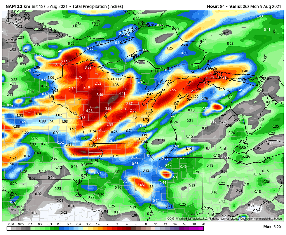
Back to the idea of heavy rain, models have latched onto the concept and between Friday and next Wednesday show widespread healthy amounts. None of these totals should be taken literally as convection is impossible to pinpoint at this distance but the coverage and amounts certainly indicate a significant trend and increased confidence for wet weather. I also want to stress there will be many dry hours but when storm clusters develop they will have the potential to produce heavy downpours with high rainfall rates. Here's a sample of what models are indicating for rain. The 3k and 12K NAM are short term models and only go out 60 and 84 hours respectively. The other models show totals through Wednesday.
The EURO

The GFS

The Canadian GEM

The Weather Prediction Center blend

The NBM blend

The 12K NAM (84 hours)

The 3K NAM (60 hours)

The other key aspect of the weather will be rising temperatures, especially early next week. Highs over the weekend should generally remain in the low to mid 80s with increasing humidity, nothing out of line for this time of year. Next week could be a different story as highs could reach or exceed 90. Debris clouds and convective blow off will have much to say about just how hot. Models have been vacillating back and forth on this issue so confidence is high that very warm muggy conditions will prevail but low on whether it's hot enough for heat index values to reach 100+.
Here's a news flash, Cedar Rapids had some rain Thursday morning. Way to go dudes! It wasn't much, .28" at the airport but it was significant as it was the first measurable rain there in 20 days. Hopefully that is a sign the dryness that has plagued that area the past 5 weeks is breaking and more rain will be in the bucket over the next few days. Any rains Friday (maybe even Saturday) should be scattered but by Sunday through Monday chances look much better for more organized convection.

By the way, the latest drought outlook is out and while most of my area is holding its own, things get nasty just to the northwest where severe to extreme drought covers much of the northern third of Iowa.

Here's a larger perspective showing much of Minnesota in a similar dilemma.

Without a doubt the weather will be more impactful the next 5-6 days has heat, humidity, and scattered thunderstorms return to the region. A much more interesting pattern for a guy like me. Happy Friday everyone and roll weather....TS


Comments