


THE SMORGASBOARD OF WEATHER...
- Oct 22, 2020
- 3 min read
Thursday will start soggy and mild around the region as strong warm advection brings heavy showers and storms. As the day wears on the warm front causing them slowly but steadily advances north and by late afternoon should be over northern Iowa and southern Wisconsin. That does two things. It temporarily shuts the rain down in most areas from north to south in the morning and it allows temperatures to warm significantly. Here's what readings are expected to look like on the EURO. You can clearly see where the warm front is located. My concern is that the front is slower than projected leaving readings cooler than what the operational models are showing, especially north of HWY 30.

The GFS is similar but a couple degrees cooler as the model is slightly slower in the push of the warm front.

One thing we should all notice is the higher levels of moisture with dew points surging into the mid 60s on the EURO. It's been some time since we saw them that high.

That contributes to instability and CAPE and while it's not extreme it's there for thunderstorms. If things time out there is a small window for a a few strong to severe storms in eastern Iowa as a wave advances along a developing cold front late in the day and into the evening. It's a rather conditional severe threat that won't be known until early afternoon but I felt it worth mentioning, especially if winds back ahead of the wave. Here's the late day CAPE, not bad for late October.

This is the severe weather threat from SPC which was upgraded to a slight risk Thursday for my western counties.

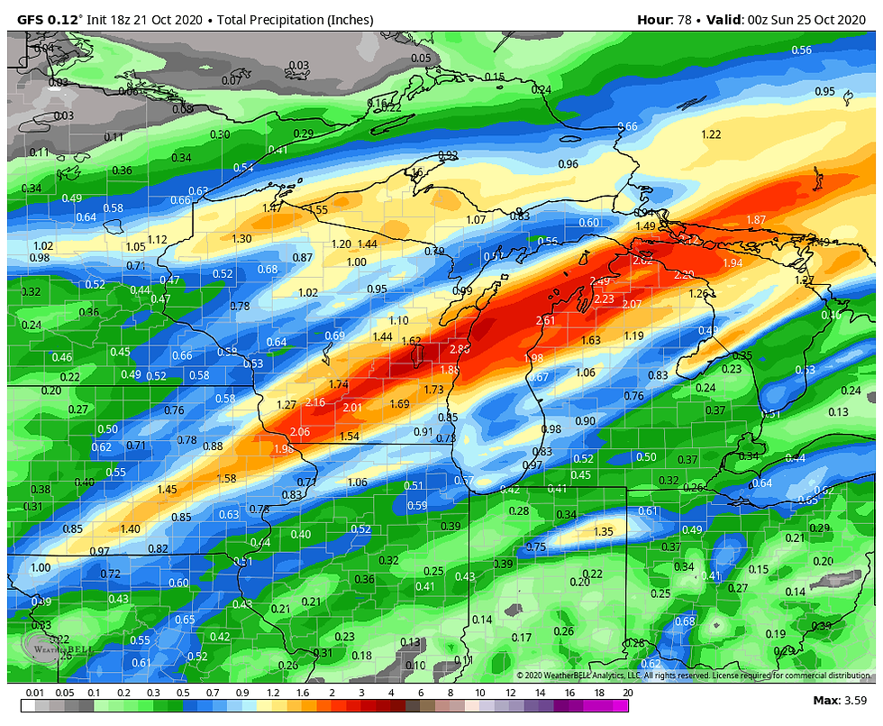
The biggest overall concern from the system will be the amount of precipitation it generates. Between the rain that has already fallen overnight and what comes Thursday night/Friday morning some 2" totals are very likely, perhaps as much as 3 or 4 where banding of convection occurs. The EURO points to this for total amounts.

The GFS looks like this.
The 3k NAM (a high res-model) is the most bullish showing some of those 3-4" amounts.

The 12k NAM has this.

Friday cold air advection is in full force behind the front and that initiates the return to sharply colder temperatures and gusty winds. At least that ends the rains in the morning. The depth of this new cold air surge will be critical to the next system Sunday night and Monday with regards to precipitation type.
As was the case yesterday the EURO and GFS are in different camps with the thermal profiles and strength of the over-running that takes place in the SW flow. To make matters worse, both models have not wavered in their overall solutions the past 4 runs. A similar thing happened last week and the GFS actually was better in defining the strength of the cold air and snow that fell Sunday and Monday so I certainly don't want to discount it. My feeling now is this ends up as some sort of compromise with the snow line cutting through the NW half of my area, especially near and NW of the Mississippi ( a very rough and preliminary guess). Here's what the EURO shows for snow totals Monday. A solid whiff in my region.

The GFS is much further south and brings more accumulating snow to my region northwest of a line from Milwaukee to Princeton, Illinois and back to Burlington, Iowa. Again it's too early to know but I do like that middle ground solution of the two solutions, at least for now.

As we wait for this situation to resolve itself I do see signs of a positive change in the pattern that should bring a warmer more typical brand of weather in about 10 days...patience everyone! This has to do with the forecast phases of the MJO, the Arctic and eastern Pacific Oscillations. I'll get more into that tomorrow. I do want to emphasize, once the chill returns this weekend it looks like next week will be well below normal. To give you an idea of the realignment that's expected, here are the day 0-5 temperature departures. Notice the extreme cold centered over Montana during the period at 5,000ft (850mb).

Now look at days 10-15. Montana has been flooded with mild Pacific air as the jet retreats to Canada. If that zonal flow develops as expected November should get off to a mild start.

Alright, that's it for a Thursday. Dodge those raindrops and enjoy the bump in temperatures this afternoon. Roll weather...TS


Comments